![](/images/other/stat-length.png)
![Trail Walking Jully-lès-Buxy - jully, la roche - Photo](https://media.geolcdn.com/t/1900/400/b7efa97d-02d5-4ab7-a816-c6a1a5d32be7.jpg&format=pjpeg&maxdim=2)
jully, la roche
margotjl
User
![Length](/images/other/stat-length.png)
Length
11.6 km
![Max alt](https://static1.geolcdn.com/siteimages/upload/files/1508320355ic_sort_altitude_max_24dp.png)
Max alt
407 m
![Uphill gradient](https://static1.geolcdn.com/siteimages/upload/files/1508320355ic_sort_den_pos_24dp.png)
Uphill gradient
274 m
![Km-Effort](/images/other/stat-length.png)
Km-Effort
15.3 km
![Min alt](https://static1.geolcdn.com/siteimages/upload/files/1508320355ic_sort_altitude_min_24dp.png)
Min alt
223 m
![Downhill gradient](https://static1.geolcdn.com/siteimages/upload/files/1508320355ic_sort_den_neg_24dp.png)
Downhill gradient
283 m
![Boucle](https://static1.geolcdn.com/siteimages/upload/files/16400158638029165_repeat_loop_refresh_sync_direction_icon.png)
Boucle
Yes
Creation date :
2020-11-28 09:03:30.687
Updated on :
2020-11-28 11:45:27.767
![Walking](https://static1.geolcdn.com/sitytour/trail-icons/101.png)
2h35
Difficulty : Easy
![Scan this QR Code to open this trail in the SityTrail application](https://capi.geolives.com/qq0zvz2zws4bq2lad0pu/sitytour/trails/2608384/qr.png?size=200)
FREE GPS app for hiking
About
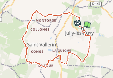
Trail Walking of 11.6 km to be discovered at Bourgogne-Franche-Comté, Saône-et-Loire, Jully-lès-Buxy. This trail is proposed by margotjl.
Description
rando agréable avec une petite pente un peu plus raide entre la tour et la Cassine.
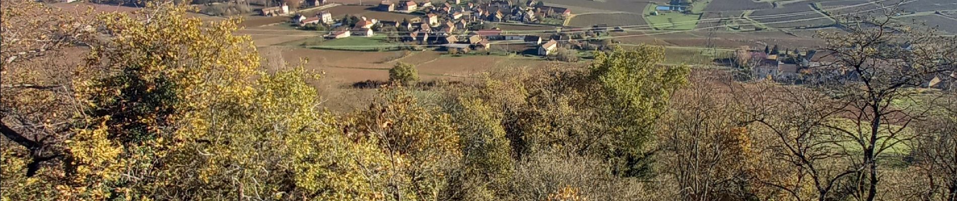
Belle depuis la vierge de Saint Vallerin
Positioning
Country:
France
Region :
Bourgogne-Franche-Comté
Department/Province :
Saône-et-Loire
Municipality :
Jully-lès-Buxy
Location:
Unknown
Start:(Dec)
Start:(UTM)
629681 ; 5172241 (31T) N.
Comments
Trails nearby
![Trail Walking Bissey-sous-Cruchaud - Bissey sous Cruchaud 09/2023 Grs - Photo](https://media.geolcdn.com/t/375/260/ext.jpg?maxdim=2&url=https%3A%2F%2Fstatic1.geolcdn.com%2Fsiteimages%2Fupload%2Ffiles%2F1553511878bg_sport_marche.png)
![Walking Walking](https://static1.geolcdn.com/sitytour/trail-icons/101.png)
Bissey sous Cruchaud 09/2023 Grs
Walking
Medium
(2)
Bissey-sous-Cruchaud,
Bourgogne-Franche-Comté,
Saône-et-Loire,
France
![](/images/other/stat-length.png)
7.6 km | 10.2 km-effort
2h 18min
![](https://static1.geolcdn.com/siteimages/upload/files/16400158638029165_repeat_loop_refresh_sync_direction_icon.png)
Yes
![Trail Walking Buxy - Chenevelles (Buxy) G2 - 2024 /DG - Photo](https://media.geolcdn.com/t/375/260/ext.jpg?maxdim=2&url=https%3A%2F%2Fstatic1.geolcdn.com%2Fsiteimages%2Fupload%2Ffiles%2F1553511878bg_sport_marche.png)
![Walking Walking](https://static1.geolcdn.com/sitytour/trail-icons/101.png)
Chenevelles (Buxy) G2 - 2024 /DG
Walking
Difficult
(1)
Buxy,
Bourgogne-Franche-Comté,
Saône-et-Loire,
France
![](/images/other/stat-length.png)
11.9 km | 15.9 km-effort
3h 37min
![](https://static1.geolcdn.com/siteimages/upload/files/16400158638029165_repeat_loop_refresh_sync_direction_icon.png)
Yes
![Trail Walking Montagny-lès-Buxy - Montagny -les-Buxy Croix de Saint-Morille - Photo](https://media.geolcdn.com/t/375/260/52bdc661-fbb1-4354-b693-d1ca2137f518.jpg&format=jpg&maxdim=2)
![Walking Walking](https://static1.geolcdn.com/sitytour/trail-icons/101.png)
Montagny -les-Buxy Croix de Saint-Morille
Walking
Medium
Montagny-lès-Buxy,
Bourgogne-Franche-Comté,
Saône-et-Loire,
France
![](/images/other/stat-length.png)
10.8 km | 14.4 km-effort
2h 50min
![](https://static1.geolcdn.com/siteimages/upload/files/16400158638029165_repeat_loop_refresh_sync_direction_icon.png)
Yes
![Trail Walking Fley - Sentier des Orchidées de Fley - Photo](https://media.geolcdn.com/t/375/260/2e12c207-193f-4737-9b4f-ee799d9d1b74.jpg&format=jpg&maxdim=2)
![Walking Walking](https://static1.geolcdn.com/sitytour/trail-icons/101.png)
Sentier des Orchidées de Fley
Walking
Easy
Fley,
Bourgogne-Franche-Comté,
Saône-et-Loire,
France
![](/images/other/stat-length.png)
16.8 km | 22 km-effort
4h 20min
![](https://static1.geolcdn.com/siteimages/upload/files/16400158638029165_repeat_loop_refresh_sync_direction_icon.png)
Yes
![Trail Walking Culles-les-Roches - Culles-les-Roches - Photo](https://media.geolcdn.com/t/375/260/5fb69117-8909-4ac8-90a4-0764d54f27b3.jpg&format=jpg&maxdim=2)
![Walking Walking](https://static1.geolcdn.com/sitytour/trail-icons/101.png)
Culles-les-Roches
Walking
Medium
Culles-les-Roches,
Bourgogne-Franche-Comté,
Saône-et-Loire,
France
![](/images/other/stat-length.png)
21 km | 27 km-effort
7h 52min
![](https://static1.geolcdn.com/siteimages/upload/files/16400158638029165_repeat_loop_refresh_sync_direction_icon.png)
Yes
![Trail Walking Montagny-lès-Buxy - noblesse, clergé et tiers etats - Photo](https://media.geolcdn.com/t/375/260/6109c572-1680-4f15-9fae-6f41c4e8a4f5.jpg&format=jpg&maxdim=2)
![Walking Walking](https://static1.geolcdn.com/sitytour/trail-icons/101.png)
noblesse, clergé et tiers etats
Walking
Medium
Montagny-lès-Buxy,
Bourgogne-Franche-Comté,
Saône-et-Loire,
France
![](/images/other/stat-length.png)
11.2 km | 15.2 km-effort
2h 22min
![](https://static1.geolcdn.com/siteimages/upload/files/16400158638029165_repeat_loop_refresh_sync_direction_icon.png)
Yes
![Trail Walking Culles-les-Roches - Culles les roches Le Château de l'Evêque page 56 - Photo](https://media.geolcdn.com/t/375/260/ext.jpg?maxdim=2&url=https%3A%2F%2Fstatic1.geolcdn.com%2Fsiteimages%2Fupload%2Ffiles%2F1553511878bg_sport_marche.png)
![Walking Walking](https://static1.geolcdn.com/sitytour/trail-icons/101.png)
Culles les roches Le Château de l'Evêque page 56
Walking
Medium
(6)
Culles-les-Roches,
Bourgogne-Franche-Comté,
Saône-et-Loire,
France
![](/images/other/stat-length.png)
12.8 km | 17.1 km-effort
3h 40min
![](https://static1.geolcdn.com/siteimages/upload/files/16400158638029165_repeat_loop_refresh_sync_direction_icon.png)
Yes
![Trail Walking Culles-les-Roches - Culles les roches Les Chaumes page 55 - Photo](https://media.geolcdn.com/t/375/260/ext.jpg?maxdim=2&url=https%3A%2F%2Fstatic1.geolcdn.com%2Fsiteimages%2Fupload%2Ffiles%2F1553511878bg_sport_marche.png)
![Walking Walking](https://static1.geolcdn.com/sitytour/trail-icons/101.png)
Culles les roches Les Chaumes page 55
Walking
Difficult
(5)
Culles-les-Roches,
Bourgogne-Franche-Comté,
Saône-et-Loire,
France
![](/images/other/stat-length.png)
12.1 km | 16.4 km-effort
3h 44min
![](https://static1.geolcdn.com/siteimages/upload/files/16400158638029165_repeat_loop_refresh_sync_direction_icon.png)
Yes
![Trail Walking Bissey-sous-Cruchaud - Bissey sous Cruchaud 3 octobre 19 - Photo](https://media.geolcdn.com/t/375/260/70434d27-d859-4783-804a-e0829e084ccb.jpg&format=jpg&maxdim=2)
![Walking Walking](https://static1.geolcdn.com/sitytour/trail-icons/101.png)
Bissey sous Cruchaud 3 octobre 19
Walking
Medium
(1)
Bissey-sous-Cruchaud,
Bourgogne-Franche-Comté,
Saône-et-Loire,
France
![](/images/other/stat-length.png)
12.5 km | 18 km-effort
3h 14min
![](https://static1.geolcdn.com/siteimages/upload/files/16400158638029165_repeat_loop_refresh_sync_direction_icon.png)
Yes