![](/images/other/stat-length.png)
![Trail On foot Volvic - chaine des puys volvic puy dome sancy volvic - Photo](https://media.geolcdn.com/t/1900/400/ext.pjpeg?maxdim=2&url=https%3A%2F%2Fstatic1.geolcdn.com%2Fsiteimages%2Fupload%2Ffiles%2F1545311037marcheuse_200dpi.jpg)
chaine des puys volvic puy dome sancy volvic
mimilolo
User
![Length](/images/other/stat-length.png)
Length
159 km
![Max alt](https://static1.geolcdn.com/siteimages/upload/files/1508320355ic_sort_altitude_max_24dp.png)
Max alt
1862 m
![Uphill gradient](https://static1.geolcdn.com/siteimages/upload/files/1508320355ic_sort_den_pos_24dp.png)
Uphill gradient
5139 m
![Km-Effort](/images/other/stat-length.png)
Km-Effort
227 km
![Min alt](https://static1.geolcdn.com/siteimages/upload/files/1508320355ic_sort_altitude_min_24dp.png)
Min alt
553 m
![Downhill gradient](https://static1.geolcdn.com/siteimages/upload/files/1508320355ic_sort_den_neg_24dp.png)
Downhill gradient
5152 m
![Boucle](https://static1.geolcdn.com/siteimages/upload/files/16400158638029165_repeat_loop_refresh_sync_direction_icon.png)
Boucle
Yes
Creation date :
2020-11-25 16:27:01.09
Updated on :
2020-11-25 16:35:52.725
![On foot](https://static1.geolcdn.com/sitytour/trail-icons/100.png)
43h20
Difficulty : Difficult
![Scan this QR Code to open this trail in the SityTrail application](https://capi.geolives.com/qq0zvz2zws4bq2lad0pu/sitytour/trails/2606837/qr.png?size=200)
FREE GPS app for hiking
About
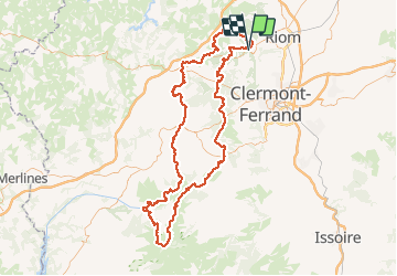
Trail On foot of 159 km to be discovered at Auvergne-Rhône-Alpes, Puy-de-Dôme, Volvic. This trail is proposed by mimilolo.
Description
depart parking ste des eaux chaine des puys GR441 puis GR4 pour rejoindre puy dome et sancy ensuite liaison par lr GR30 lac de guery reprise du GR441 jusqu'à volvic
Positioning
Country:
France
Region :
Auvergne-Rhône-Alpes
Department/Province :
Puy-de-Dôme
Municipality :
Volvic
Location:
Unknown
Start:(Dec)
Start:(UTM)
502156 ; 5079731 (31T) N.
Comments
Trails nearby
![Trail Walking Blanzat - Blanzat_Plateau_Bade - Photo](https://media.geolcdn.com/t/375/260/0f6960c3-6461-4500-bc08-d408282d7c8a.jpg&format=jpg&maxdim=2)
![Walking Walking](https://static1.geolcdn.com/sitytour/trail-icons/101.png)
Blanzat_Plateau_Bade
Walking
Easy
(1)
Blanzat,
Auvergne-Rhône-Alpes,
Puy-de-Dôme,
France
![](/images/other/stat-length.png)
5.5 km | 7.2 km-effort
1h 45min
![](https://static1.geolcdn.com/siteimages/upload/files/16400158638029165_repeat_loop_refresh_sync_direction_icon.png)
Yes
![Trail Walking Chanat-la-Mouteyre - Chanat_Trois_Villages - Photo](https://media.geolcdn.com/t/375/260/f6aed3b2-f876-470f-b6b5-0e9d2ed9b804.jpg&format=jpg&maxdim=2)
![Walking Walking](https://static1.geolcdn.com/sitytour/trail-icons/101.png)
Chanat_Trois_Villages
Walking
Medium
(1)
Chanat-la-Mouteyre,
Auvergne-Rhône-Alpes,
Puy-de-Dôme,
France
![](/images/other/stat-length.png)
10 km | 14 km-effort
3h 0min
![](https://static1.geolcdn.com/siteimages/upload/files/16400158638029165_repeat_loop_refresh_sync_direction_icon.png)
Yes
![Trail Walking Enval - Enval_Gorges - Photo](https://media.geolcdn.com/t/375/260/6439ff7d-6f0e-45b4-9186-1ec0cb9dacc2.jpg&format=jpg&maxdim=2)
![Walking Walking](https://static1.geolcdn.com/sitytour/trail-icons/101.png)
Enval_Gorges
Walking
Medium
(1)
Enval,
Auvergne-Rhône-Alpes,
Puy-de-Dôme,
France
![](/images/other/stat-length.png)
9.1 km | 13.2 km-effort
2h 45min
![](https://static1.geolcdn.com/siteimages/upload/files/16400158638029165_repeat_loop_refresh_sync_direction_icon.png)
Yes
![Trail Walking Sayat - Sayat_Repaire_Gaulois - Photo](https://media.geolcdn.com/t/375/260/d799b2b9-9f9f-418d-82a8-76cd808ed9e7.jpg&format=jpg&maxdim=2)
![Walking Walking](https://static1.geolcdn.com/sitytour/trail-icons/101.png)
Sayat_Repaire_Gaulois
Walking
Easy
(1)
Sayat,
Auvergne-Rhône-Alpes,
Puy-de-Dôme,
France
![](/images/other/stat-length.png)
6.1 km | 9.3 km-effort
1h 59min
![](https://static1.geolcdn.com/siteimages/upload/files/16400158638029165_repeat_loop_refresh_sync_direction_icon.png)
Yes
![Trail Walking Châtel-Guyon - Chazeron sans souci - Photo](https://media.geolcdn.com/t/375/260/ext.jpg?maxdim=2&url=https%3A%2F%2Fservices.sitytrail.com%2FGeolivesWS%2FDownloadMedia.ashx%3FTrailID%3D324974%26Media%3Dfix__20140716162721.jpg)
![Walking Walking](https://static1.geolcdn.com/sitytour/trail-icons/101.png)
Chazeron sans souci
Walking
Easy
(1)
Châtel-Guyon,
Auvergne-Rhône-Alpes,
Puy-de-Dôme,
France
![](/images/other/stat-length.png)
6.6 km | 9.7 km-effort
1h 45min
![](https://static1.geolcdn.com/siteimages/upload/files/16400158638029165_repeat_loop_refresh_sync_direction_icon.png)
Yes
![Trail Walking Châtel-Guyon - Boucle de Rochepradière en passant par Douhady - Photo](https://media.geolcdn.com/t/375/260/ext.jpg?maxdim=2&url=https%3A%2F%2Fservices.sitytrail.com%2FGeolivesWS%2FDownloadMedia.ashx%3FTrailID%3D320023%26Media%3Dfix__20140701160258.jpg)
![Walking Walking](https://static1.geolcdn.com/sitytour/trail-icons/101.png)
Boucle de Rochepradière en passant par Douhady
Walking
Easy
(1)
Châtel-Guyon,
Auvergne-Rhône-Alpes,
Puy-de-Dôme,
France
![](/images/other/stat-length.png)
6.7 km | 9.7 km-effort
2h 6min
![](https://static1.geolcdn.com/siteimages/upload/files/16400158638029165_repeat_loop_refresh_sync_direction_icon.png)
Yes
![Trail Walking Châtel-Guyon - Le tour de Montaclier - Saint Hippolyte - Photo](https://media.geolcdn.com/t/375/260/ext.jpg?maxdim=2&url=https%3A%2F%2Fservices.sitytrail.com%2FGeolivesWS%2FDownloadMedia.ashx%3FTrailID%3D317669%26Media%3D16954_5.jpg)
![Walking Walking](https://static1.geolcdn.com/sitytour/trail-icons/101.png)
Le tour de Montaclier - Saint Hippolyte
Walking
Difficult
(1)
Châtel-Guyon,
Auvergne-Rhône-Alpes,
Puy-de-Dôme,
France
![](/images/other/stat-length.png)
14 km | 19.6 km-effort
3h 30min
![](https://static1.geolcdn.com/siteimages/upload/files/16400158638029165_repeat_loop_refresh_sync_direction_icon.png)
Yes
![Trail Mountain bike Volvic - Tour du Puy de Dôme en VTT - Photo](https://media.geolcdn.com/t/375/260/ext.jpg?maxdim=2&url=https%3A%2F%2Fservices.sitytrail.com%2FGeolivesWS%2FDownloadMedia.ashx%3FTrailID%3D191407%26Media%3D14983_4.jpg)
![Mountain bike Mountain bike](https://static1.geolcdn.com/sitytour/trail-icons/202.png)
Tour du Puy de Dôme en VTT
Mountain bike
Very difficult
(1)
Volvic,
Auvergne-Rhône-Alpes,
Puy-de-Dôme,
France
![](/images/other/stat-length.png)
62 km | 85 km-effort
5h 30min
![](https://static1.geolcdn.com/siteimages/upload/files/16400158638029165_repeat_loop_refresh_sync_direction_icon.png)
Yes
![Trail Walking Volvic - Les sources de Volvic - Photo](https://media.geolcdn.com/t/375/260/ext.jpg?maxdim=2&url=https%3A%2F%2Fservices.sitytrail.com%2FGeolivesWS%2FDownloadMedia.ashx%3FTrailID%3D102879%26Media%3D4090_1.jpg)
![Walking Walking](https://static1.geolcdn.com/sitytour/trail-icons/101.png)
Les sources de Volvic
Walking
Medium
(2)
Volvic,
Auvergne-Rhône-Alpes,
Puy-de-Dôme,
France
![](/images/other/stat-length.png)
10.9 km | 14.3 km-effort
3h 0min
![](https://static1.geolcdn.com/siteimages/upload/files/16400158638029165_repeat_loop_refresh_sync_direction_icon.png)
Yes