![](/images/other/stat-length.png)
![Trail Nordic walking Châteaudun - Marche_Chateaudun_20140326 - Photo](https://media.geolcdn.com/t/1900/400/ext.pjpeg?maxdim=2&url=https%3A%2F%2Fstatic1.geolcdn.com%2Fsiteimages%2Fupload%2Ffiles%2F1545311037marcheuse_200dpi.jpg)
Marche_Chateaudun_20140326
chlafaille
User
![Length](/images/other/stat-length.png)
Length
21 km
![Max alt](https://static1.geolcdn.com/siteimages/upload/files/1508320355ic_sort_altitude_max_24dp.png)
Max alt
154 m
![Uphill gradient](https://static1.geolcdn.com/siteimages/upload/files/1508320355ic_sort_den_pos_24dp.png)
Uphill gradient
254 m
![Km-Effort](/images/other/stat-length.png)
Km-Effort
24 km
![Min alt](https://static1.geolcdn.com/siteimages/upload/files/1508320355ic_sort_altitude_min_24dp.png)
Min alt
105 m
![Downhill gradient](https://static1.geolcdn.com/siteimages/upload/files/1508320355ic_sort_den_neg_24dp.png)
Downhill gradient
256 m
![Boucle](https://static1.geolcdn.com/siteimages/upload/files/16400158638029165_repeat_loop_refresh_sync_direction_icon.png)
Boucle
Yes
Creation date :
2014-12-10 00:00:00.0
Updated on :
2014-12-10 00:00:00.0
![Nordic walking](https://static1.geolcdn.com/sitytour/trail-icons/102.png)
3h42
Difficulty : Difficult
![Scan this QR Code to open this trail in the SityTrail application](https://capi.geolives.com/qq0zvz2zws4bq2lad0pu/sitytour/trails/260670/qr.png?size=200)
FREE GPS app for hiking
About
Trail Nordic walking of 21 km to be discovered at Centre-Loire Valley, Eure-et-Loir, Châteaudun. This trail is proposed by chlafaille.
Description
INFORMATION: mon GPS s'est "désaligné" sur la portion Est de mon parcours (entre "le Moulin à Tan" et "Le Croc Marbot")... il faut bien suivre le GR35 sur cette partie.
Positioning
Country:
France
Region :
Centre-Loire Valley
Department/Province :
Eure-et-Loir
Municipality :
Châteaudun
Location:
Unknown
Start:(Dec)
Start:(UTM)
375707 ; 5325067 (31U) N.
Comments
Trails nearby
![Trail Walking Châteaudun - Châteaudun - Marboué - Photo](https://media.geolcdn.com/t/375/260/6fc7324d-3026-46fa-8ba5-43d23d854789.jpg&format=jpg&maxdim=2)
![Walking Walking](https://static1.geolcdn.com/sitytour/trail-icons/101.png)
Châteaudun - Marboué
Walking
Medium
Châteaudun,
Centre-Loire Valley,
Eure-et-Loir,
France
![](/images/other/stat-length.png)
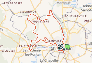
19.2 km | 22 km-effort
6h 25min
![](https://static1.geolcdn.com/siteimages/upload/files/16400158638029165_repeat_loop_refresh_sync_direction_icon.png)
Yes
![Trail Mountain bike Châteaudun - Le moulin de Courgain - Châteaudin - Photo](https://media.geolcdn.com/t/375/260/ext.jpg?maxdim=2&url=https%3A%2F%2Fservices.sitytrail.com%2FGeolivesWS%2FDownloadMedia.ashx%3FTrailID%3D215150%26Media%3D15745_2.jpg)
![Mountain bike Mountain bike](https://static1.geolcdn.com/sitytour/trail-icons/202.png)
Le moulin de Courgain - Châteaudin
Mountain bike
Difficult
Châteaudun,
Centre-Loire Valley,
Eure-et-Loir,
France
![](/images/other/stat-length.png)
33 km | 39 km-effort
1h 49min
![](https://static1.geolcdn.com/siteimages/upload/files/16400158638029165_repeat_loop_refresh_sync_direction_icon.png)
Yes
![Trail Walking Châteaudun - Châteaudun 1 - Photo](https://media.geolcdn.com/t/375/260/ext.jpg?maxdim=2&url=https%3A%2F%2Fstatic1.geolcdn.com%2Fsiteimages%2Fupload%2Ffiles%2F1553511878bg_sport_marche.png)
![Walking Walking](https://static1.geolcdn.com/sitytour/trail-icons/101.png)
Châteaudun 1
Walking
Medium
Châteaudun,
Centre-Loire Valley,
Eure-et-Loir,
France
![](/images/other/stat-length.png)
9 km | 10.2 km-effort
2h 46min
![](https://static1.geolcdn.com/siteimages/upload/files/16400158638029165_repeat_loop_refresh_sync_direction_icon.png)
Yes
![Trail On foot Cloyes-les-Trois-Rivières - Douy PC27sept2020 - Photo](https://media.geolcdn.com/t/375/260/ext.jpg?maxdim=2&url=https%3A%2F%2Fstatic1.geolcdn.com%2Fsiteimages%2Fupload%2Ffiles%2F1545311037marcheuse_200dpi.jpg)
![On foot On foot](https://static1.geolcdn.com/sitytour/trail-icons/100.png)
Douy PC27sept2020
On foot
Medium
Cloyes-les-Trois-Rivières,
Centre-Loire Valley,
Eure-et-Loir,
France
![](/images/other/stat-length.png)
11.3 km | 13 km-effort
Unknown
![](https://static1.geolcdn.com/siteimages/upload/files/16400158638029165_repeat_loop_refresh_sync_direction_icon.png)
Yes
![Trail On foot Châteaudun - Châteaudun PC25sept2020 - Photo](https://media.geolcdn.com/t/375/260/ext.jpg?maxdim=2&url=https%3A%2F%2Fstatic1.geolcdn.com%2Fsiteimages%2Fupload%2Ffiles%2F1545311037marcheuse_200dpi.jpg)
![On foot On foot](https://static1.geolcdn.com/sitytour/trail-icons/100.png)
Châteaudun PC25sept2020
On foot
Medium
Châteaudun,
Centre-Loire Valley,
Eure-et-Loir,
France
![](/images/other/stat-length.png)
9.6 km | 11.1 km-effort
Unknown
![](https://static1.geolcdn.com/siteimages/upload/files/16400158638029165_repeat_loop_refresh_sync_direction_icon.png)
Yes
![Trail Mountain bike Châteaudun - Le moulin de Courgain - Chateaudin - Photo](https://media.geolcdn.com/t/375/260/ext.jpg?maxdim=2&url=https%3A%2F%2Fstatic1.geolcdn.com%2Fsiteimages%2Fupload%2Ffiles%2F1524743154velo.jpg)
![Mountain bike Mountain bike](https://static1.geolcdn.com/sitytour/trail-icons/202.png)
Le moulin de Courgain - Chateaudin
Mountain bike
Difficult
Châteaudun,
Centre-Loire Valley,
Eure-et-Loir,
France
![](/images/other/stat-length.png)
34 km | 39 km-effort
1h 49min
![](https://static1.geolcdn.com/siteimages/upload/files/16400158638029165_repeat_loop_refresh_sync_direction_icon.png)
Yes
![Trail Walking Châteaudun - Chateaudun (Boucle Plaines et Vallées du Dunois) - Photo](https://media.geolcdn.com/t/375/260/ext.jpg?maxdim=2&url=https%3A%2F%2Fstatic1.geolcdn.com%2Fsiteimages%2Fupload%2Ffiles%2F1553511878bg_sport_marche.png)
![Walking Walking](https://static1.geolcdn.com/sitytour/trail-icons/101.png)
Chateaudun (Boucle Plaines et Vallées du Dunois)
Walking
Easy
Châteaudun,
Centre-Loire Valley,
Eure-et-Loir,
France
![](/images/other/stat-length.png)
18.9 km | 22 km-effort
4h 47min
![](https://static1.geolcdn.com/siteimages/upload/files/16400158638029165_repeat_loop_refresh_sync_direction_icon.png)
Yes
![Trail Walking Châteaudun - 009 Chateaudun Cloyes - Photo](https://media.geolcdn.com/t/375/260/ext.jpg?maxdim=2&url=https%3A%2F%2Fstatic1.geolcdn.com%2Fsiteimages%2Fupload%2Ffiles%2F1553511878bg_sport_marche.png)
![Walking Walking](https://static1.geolcdn.com/sitytour/trail-icons/101.png)
009 Chateaudun Cloyes
Walking
Very easy
Châteaudun,
Centre-Loire Valley,
Eure-et-Loir,
France
![](/images/other/stat-length.png)
13.6 km | 15 km-effort
3h 19min
![](https://static1.geolcdn.com/siteimages/upload/files/16400158638029165_repeat_loop_refresh_sync_direction_icon.png)
No
![Trail Mountain bike Cloyes-les-Trois-Rivières - Haute vallée du Loir en VTT - Photo](https://media.geolcdn.com/t/375/260/ext.jpg?maxdim=2&url=https%3A%2F%2Fstatic1.geolcdn.com%2Fsiteimages%2Fupload%2Ffiles%2F1524743154velo.jpg)
![Mountain bike Mountain bike](https://static1.geolcdn.com/sitytour/trail-icons/202.png)
Haute vallée du Loir en VTT
Mountain bike
Difficult
Cloyes-les-Trois-Rivières,
Centre-Loire Valley,
Eure-et-Loir,
France
![](/images/other/stat-length.png)
82 km | 94 km-effort
4h 10min
![](https://static1.geolcdn.com/siteimages/upload/files/16400158638029165_repeat_loop_refresh_sync_direction_icon.png)
Yes