![](/images/other/stat-length.png)
![Trail Walking Holsbeek - Horst - Photo](https://media.geolcdn.com/t/1900/400/ext.pjpeg?maxdim=2&url=https%3A%2F%2Fstatic1.geolcdn.com%2Fsiteimages%2Fupload%2Ffiles%2F1553511878bg_sport_marche.png)
Horst
pitteke1
User
![Length](/images/other/stat-length.png)
Length
11.1 km
![Max alt](https://static1.geolcdn.com/siteimages/upload/files/1508320355ic_sort_altitude_max_24dp.png)
Max alt
94 m
![Uphill gradient](https://static1.geolcdn.com/siteimages/upload/files/1508320355ic_sort_den_pos_24dp.png)
Uphill gradient
137 m
![Km-Effort](/images/other/stat-length.png)
Km-Effort
13 km
![Min alt](https://static1.geolcdn.com/siteimages/upload/files/1508320355ic_sort_altitude_min_24dp.png)
Min alt
23 m
![Downhill gradient](https://static1.geolcdn.com/siteimages/upload/files/1508320355ic_sort_den_neg_24dp.png)
Downhill gradient
138 m
![Boucle](https://static1.geolcdn.com/siteimages/upload/files/16400158638029165_repeat_loop_refresh_sync_direction_icon.png)
Boucle
Yes
Creation date :
2020-11-18 10:24:28.502
Updated on :
2020-11-27 10:50:49.041
![Walking](https://static1.geolcdn.com/sitytour/trail-icons/101.png)
3h19
Difficulty : Easy
![Scan this QR Code to open this trail in the SityTrail application](https://capi.geolives.com/qq0zvz2zws4bq2lad0pu/sitytour/trails/2602991/qr.png?size=200)
FREE GPS app for hiking
About
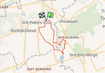
Trail Walking of 11.1 km to be discovered at Flanders, Flemish Brabant, Holsbeek. This trail is proposed by pitteke1.
Description
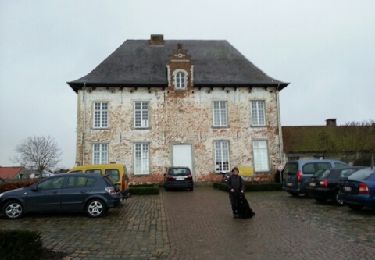
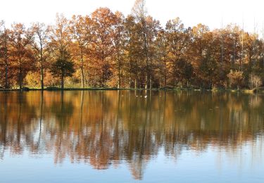
Très belle rando variée, du château de Horst (Sint-Pieters-Rode - Vlaams Brabant) au moulin de Gempe et retour. Vastes paysages, ruisseau, forêt.
Rando proposée par l'office du tourisme du Brabant flamand.
Positioning
Country:
Belgium
Region :
Flanders
Department/Province :
Flemish Brabant
Municipality :
Holsbeek
Location:
Sint-Pieters-Rode
Start:(Dec)
Start:(UTM)
628801 ; 5643934 (31U) N.
Comments
Trails nearby
![Trail Walking Holsbeek - Korttijk Dutsel - Photo](https://media.geolcdn.com/t/375/260/ext.jpg?maxdim=2&url=https%3A%2F%2Fservices.sitytrail.com%2FGeolivesWS%2FDownloadMedia.ashx%3FTrailID%3D167947%26Media%3D20121230101424.jpeg)
![Walking Walking](https://static1.geolcdn.com/sitytour/trail-icons/101.png)
Korttijk Dutsel
Walking
Easy
(1)
Holsbeek,
Flanders,
Flemish Brabant,
Belgium
![](/images/other/stat-length.png)
7.7 km | 8.8 km-effort
1h 45min
![](https://static1.geolcdn.com/siteimages/upload/files/16400158638029165_repeat_loop_refresh_sync_direction_icon.png)
Yes
![Trail On foot Holsbeek - Hagelandse Vallei Rode driehoek - Photo](https://media.geolcdn.com/t/375/260/97bc77ac-1b06-4197-96ed-16097cd5c611.jpeg&format=jpg&maxdim=2)
![On foot On foot](https://static1.geolcdn.com/sitytour/trail-icons/100.png)
Hagelandse Vallei Rode driehoek
On foot
Easy
Holsbeek,
Flanders,
Flemish Brabant,
Belgium
![](/images/other/stat-length.png)
9.9 km | 11.5 km-effort
2h 36min
![](https://static1.geolcdn.com/siteimages/upload/files/16400158638029165_repeat_loop_refresh_sync_direction_icon.png)
Yes
![Trail On foot Holsbeek - Hagelandse Vallei Oranje bol - Photo](https://media.geolcdn.com/t/375/260/584f6b47-ae61-4a88-a68d-8ff488d96db6.jpeg&format=jpg&maxdim=2)
![On foot On foot](https://static1.geolcdn.com/sitytour/trail-icons/100.png)
Hagelandse Vallei Oranje bol
On foot
Easy
Holsbeek,
Flanders,
Flemish Brabant,
Belgium
![](/images/other/stat-length.png)
5.5 km | 6 km-effort
1h 21min
![](https://static1.geolcdn.com/siteimages/upload/files/16400158638029165_repeat_loop_refresh_sync_direction_icon.png)
Yes
![Trail On foot Holsbeek - Wingewandeling - Photo](https://media.geolcdn.com/t/375/260/ef81006a-abe0-42fd-889a-48565cc240bc.jpeg&format=jpg&maxdim=2)
![On foot On foot](https://static1.geolcdn.com/sitytour/trail-icons/100.png)
Wingewandeling
On foot
Easy
Holsbeek,
Flanders,
Flemish Brabant,
Belgium
![](/images/other/stat-length.png)
3.3 km | 3.6 km-effort
48min
![](https://static1.geolcdn.com/siteimages/upload/files/16400158638029165_repeat_loop_refresh_sync_direction_icon.png)
Yes
![Trail On foot Holsbeek - Peersewandeling - Photo](https://media.geolcdn.com/t/375/260/ef81006a-abe0-42fd-889a-48565cc240bc.jpeg&format=jpg&maxdim=2)
![On foot On foot](https://static1.geolcdn.com/sitytour/trail-icons/100.png)
Peersewandeling
On foot
Easy
Holsbeek,
Flanders,
Flemish Brabant,
Belgium
![](/images/other/stat-length.png)
3.4 km | 3.9 km-effort
52min
![](https://static1.geolcdn.com/siteimages/upload/files/16400158638029165_repeat_loop_refresh_sync_direction_icon.png)
Yes
![Trail On foot Holsbeek - Domeinwandeling - Photo](https://media.geolcdn.com/t/375/260/ef81006a-abe0-42fd-889a-48565cc240bc.jpeg&format=jpg&maxdim=2)
![On foot On foot](https://static1.geolcdn.com/sitytour/trail-icons/100.png)
Domeinwandeling
On foot
Easy
Holsbeek,
Flanders,
Flemish Brabant,
Belgium
![](/images/other/stat-length.png)
3.2 km | 3.5 km-effort
47min
![](https://static1.geolcdn.com/siteimages/upload/files/16400158638029165_repeat_loop_refresh_sync_direction_icon.png)
Yes
![Trail On foot Aarschot - Kloesebos Rode driehoek - Photo](https://media.geolcdn.com/t/375/260/f4a0c03f-0ec6-441f-abfb-a6b5b510b476.jpeg&format=jpg&maxdim=2)
![On foot On foot](https://static1.geolcdn.com/sitytour/trail-icons/100.png)
Kloesebos Rode driehoek
On foot
Easy
Aarschot,
Flanders,
Flemish Brabant,
Belgium
![](/images/other/stat-length.png)
9.8 km | 11.7 km-effort
2h 39min
![](https://static1.geolcdn.com/siteimages/upload/files/16400158638029165_repeat_loop_refresh_sync_direction_icon.png)
Yes
![Trail On foot Aarschot - Kloesebos Blauwe ruit - Photo](https://media.geolcdn.com/t/375/260/66cc2f8c-dfb7-4bf1-9239-18bc78c78aaf.jpeg&format=jpg&maxdim=2)
![On foot On foot](https://static1.geolcdn.com/sitytour/trail-icons/100.png)
Kloesebos Blauwe ruit
On foot
Easy
Aarschot,
Flanders,
Flemish Brabant,
Belgium
![](/images/other/stat-length.png)
3 km | 3.6 km-effort
49min
![](https://static1.geolcdn.com/siteimages/upload/files/16400158638029165_repeat_loop_refresh_sync_direction_icon.png)
Yes
![Trail On foot Aarschot - Rillaarse Heuvelswandeling - Photo](https://media.geolcdn.com/t/375/260/2883ed0c-1972-44a3-9264-788ac17d3bac.jpeg&format=jpg&maxdim=2)
![On foot On foot](https://static1.geolcdn.com/sitytour/trail-icons/100.png)
Rillaarse Heuvelswandeling
On foot
Easy
Aarschot,
Flanders,
Flemish Brabant,
Belgium
![](/images/other/stat-length.png)
12.2 km | 14.6 km-effort
3h 18min
![](https://static1.geolcdn.com/siteimages/upload/files/16400158638029165_repeat_loop_refresh_sync_direction_icon.png)
Yes