Trail Cycle Copeland - C2C - Photo
 toby101
toby101

User

© OpenStreetMap contributors
Length
Length
231 km
Max alt
Max alt
608 m
Uphill gradient
Uphill gradient
3910 m
Km-Effort
Km-Effort  
283 km
Min alt
Min alt
-1 m
Downhill gradient
Downhill gradient
3913 m
Boucle
Boucle
No
Creation date :
2014-12-10 00:00:00.0
Updated on :
2014-12-10 00:00:00.0

(0 Reviews)

Cycle
Cycle
--
Difficulty : Medium

Scan this QR Code to open this trail in the SityTrail application

FREE GPS app for hiking

Logo SityTrail SityTrail

IGN / Geographical institutes

Download SityTrail from the App Store Download SityTrail from Google Play

Logo SityTrail SityTrail World

The world is yours!

Download SityTrail from the App Store Download SityTrail from Google Play Download SityTrail on Huawei AppGallery

About

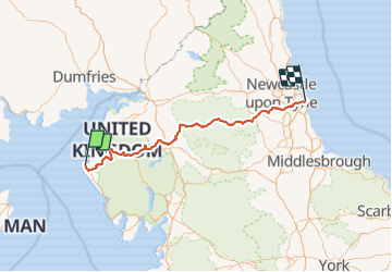
Trail Cycle of 231 km to be discovered at England, Cumbria, Copeland. This trail is proposed by toby101.

Description

UK C2C

Elevation profile

Positioning

Country:
United Kingdom
Region :
England
Department/Province :
Cumbria
Municipality :
Copeland
Location:
Unknown
Start:(UTM)
461720 ; 6044727 (30U) N.

Trails nearby

Trail Walking Copeland - w-engeland-coast-to-coast - Photo
Walking
gpstracks

Walking

Very easy
Copeland, England, Cumbria, United Kingdom
321 km | 429 km-effort
Unknown
No


Close
My subscriptions