Trail On foot Templeuve-en-Pévèle - TDC circuit de la Cloqueterrie 6.8 Km - Photo

TDC circuit de la Cloqueterrie 6.8 Km

© OpenStreetMap contributors
Length
Length
6.8 km
Max alt
Max alt
35 m
Uphill gradient
Uphill gradient
26 m
Km-Effort
Km-Effort  
7.1 km
Min alt
Min alt
26 m
Downhill gradient
Downhill gradient
26 m
Boucle
Boucle
Yes
Creation date :
2020-11-04 16:51:12.028
Updated on :
2020-11-04 16:54:30.919

(0 Reviews)

On foot
On foot
--
Difficulty : Very easy

Scan this QR Code to open this trail in the SityTrail application

FREE GPS app for hiking

Logo SityTrail SityTrail

IGN / Geographical institutes

Download SityTrail from the App Store Download SityTrail from Google Play

Logo SityTrail SityTrail World

The world is yours!

Download SityTrail from the App Store Download SityTrail from Google Play Download SityTrail on Huawei AppGallery

About

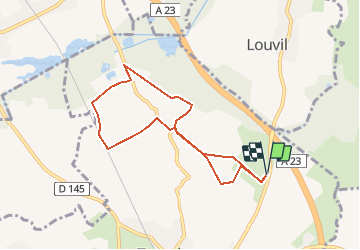
Trail On foot of 6.8 km to be discovered at Hauts-de-France, Nord, Templeuve-en-Pévèle. This trail is proposed by Marcheur2020.

Description

Depart sortie de Louvil direction Templeuve aprrès le pont l'autoroute.

Elevation profile

Positioning

Country:
France
Region :
Hauts-de-France
Department/Province :
Nord
Municipality :
Templeuve-en-Pévèle
Location:
Unknown
Start:(UTM)
513434 ; 5598954 (31U) N.

Trails nearby

Trail Mountain bike Bachy - De Bachy à Gruson   - Photo
Mountain bike
tracegps

Mountain bike

Medium
(1)
Bachy, Hauts-de-France, Nord, France
21 km | 23 km-effort
1h 30min
Yes
Trail Equestrian Cappelle-en-Pévèle - Boucle des Pavés - Capelle en Pévèle  - Photo
Equestrian
tracegps

Equestrian

Medium
(1)
Cappelle-en-Pévèle, Hauts-de-France, Nord, France
17.7 km | 18.7 km-effort
2h 45min
Yes
Trail Walking Ennevelin - Circuit d'Aigremont - Photo
Walking
tracegps

Walking

Medium
(1)
Ennevelin, Hauts-de-France, Nord, France
11.1 km | 11.8 km-effort
2h 45min
Yes
Trail Walking Cobrieux - Circuit de la Commanderie à Cobrieux - Photo
Walking
tracegps

Walking

Medium
(1)
Cobrieux, Hauts-de-France, Nord, France
11.8 km | 12.9 km-effort
3h 0min
Yes
Trail Walking Péronne-en-Mélantois - Péronne en Mélantois et ses marais - Photo
Walking
tracegps

Walking

Medium
(1)
Péronne-en-Mélantois, Hauts-de-France, Nord, France
13.1 km | 14 km-effort
3h 15min
Yes
Trail Walking Fretin - Mélantois - La Marque - Photo
Walking
Greg813

Walking

Easy
(1)
Fretin, Hauts-de-France, Nord, France
13.9 km | 14.9 km-effort
3h 10min
Yes
Trail Walking Fretin - Sur les traces de Philippe II Auguste - Photo
Walking

Walking

Easy
(1)
Fretin, Hauts-de-France, Nord, France
26 km | 28 km-effort
5h 12min
Yes
Trail Walking Cobrieux - cobrieux - Photo
Walking
Templeuveenmarche

Walking

Very easy
(1)
Cobrieux, Hauts-de-France, Nord, France
9.5 km | 10.4 km-effort
56min
Yes
Trail Walking Fretin - fretin et ses marais - Photo
Walking
dehemjacques

Walking

Easy
(2)
Fretin, Hauts-de-France, Nord, France
12 km | 12.7 km-effort
2h 31min
Yes


Close
My subscriptions