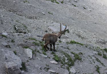
Trail Walking Grandvillard - Le Vanil Noir par Bounavaux - Photo

Le Vanil Noir par Bounavaux

 otrement
otrement

User

© OpenStreetMap contributors
Length
Length
8.6 km
Max alt
Max alt
2366 m
Uphill gradient
Uphill gradient
1084 m
Km-Effort
Km-Effort  
23 km
Min alt
Min alt
1279 m
Downhill gradient
Downhill gradient
1084 m
Boucle
Boucle
Yes
Creation date :
2014-12-11 00:00:00.0
Updated on :
2014-12-11 00:00:00.0

(0 Reviews)

Walking
Walking
4h40
Difficulty : Unknown

Scan this QR Code to open this trail in the SityTrail application

FREE GPS app for hiking

Logo SityTrail SityTrail

IGN / Geographical institutes

Download SityTrail from the App Store Download SityTrail from Google Play

Logo SityTrail SityTrail World

The world is yours!

Download SityTrail from the App Store Download SityTrail from Google Play Download SityTrail on Huawei AppGallery

About

Trail Walking of 8.6 km to be discovered at Fribourg, Gruyère District, Grandvillard. This trail is proposed by otrement.

Description

Depuis le parking, la montée sur Bounavaux permet d''admirer la flore abondante de cette région. Plus haut, le sentier se descine dans une pente raide direction Plan des Eaux. Ne manquez pas de saluer les bouquetins toujours très nombreux sur ce col. L''arrête menant au sommet et vertigineuse (prendre garde par temps de pluie). Le panorama du sommet et simplement sompteux. La descente par le nord peut également se faire par l''arrête jusqu''à la Tête de l''Herbette avant de rejoindre le Col de Bounavalette puis à nouveau Bounavaux et le parking.

Elevation profile

Positioning

Country:
Switzerland
Region :
Fribourg
Department/Province :
Gruyère District
Municipality :
Grandvillard
Location:
Unknown
Start:(UTM)
355486 ; 5155335 (32T) N.

Trails nearby

Trail On foot Val-de-Charmey - Les Marindes-Motélon - Photo
On foot
GUIDE+

On foot

Easy
Val-de-Charmey, Fribourg, Gruyère District, Switzerland
4.5 km | 9.7 km-effort
2h 12min
No
Trail On foot Bas-Intyamon - Motélon-La Gueyre - Photo
On foot
GUIDE+

On foot

Easy
Bas-Intyamon, Fribourg, Gruyère District, Switzerland
6.4 km | 14.3 km-effort
3h 14min
No
Trail Other activity Bas-Intyamon - y10_poyas - Photo
Other activity
GUIDE+

Other activity

Very easy
Bas-Intyamon, Fribourg, Gruyère District, Switzerland
16.1 km | 25 km-effort
5h 43min
No
Trail Walking Haut-Intyamon - Comba d’Avau – Montbovon - Photo
Walking
gpiller

Walking

Medium
Haut-Intyamon, Fribourg, Gruyère District, Switzerland
8.1 km | 12 km-effort
2h 30min
Yes
Trail Other activity Val-de-Charmey - Marindes Charmey - Photo
Other activity
lush

Other activity

Very easy
Val-de-Charmey, Fribourg, Gruyère District, Switzerland
14.7 km | 20 km-effort
Unknown
No
Trail Other activity Grandvillard - Bounavaux Montbovon - Photo
Other activity
lush

Other activity

Very easy
Grandvillard, Fribourg, Gruyère District, Switzerland
12.8 km | 19.2 km-effort
Unknown
No
Trail Other activity Grandvillard - Curtillet - Photo
Other activity
haerri-arnold

Other activity

Very easy
Grandvillard, Fribourg, Gruyère District, Switzerland
10.3 km | 24 km-effort
Unknown
Yes
Trail Other activity  - Lessoc - Chaudzerya - Pertet - La Brâ - Lessoc - Photo
Other activity
fblessoc

Other activity

Very easy
, Fribourg, Gruyère District, Switzerland
10.2 km | 19.9 km-effort
Unknown
Yes
Trail Other activity  - Lessoc - La Brâ - Sonlomont - Montbovon - Photo
Other activity
fblessoc

Other activity

Very easy
, Fribourg, Gruyère District, Switzerland
6.6 km | 15.6 km-effort
Unknown
No


Close
My subscriptions