![](/images/other/stat-length.png)
![Trail Walking Villard-de-Lans - crête de Ferrière et pas de Rages - Photo](https://media.geolcdn.com/t/1900/400/366bd126-b053-4e11-9a71-f5b68c70d969.jpg&format=pjpeg&maxdim=2)
crête de Ferrière et pas de Rages
nadd73
User GUIDE
![Length](/images/other/stat-length.png)
![Max alt](https://static1.geolcdn.com/siteimages/upload/files/1508320355ic_sort_altitude_max_24dp.png)
![Uphill gradient](https://static1.geolcdn.com/siteimages/upload/files/1508320355ic_sort_den_pos_24dp.png)
![Km-Effort](/images/other/stat-length.png)
![Min alt](https://static1.geolcdn.com/siteimages/upload/files/1508320355ic_sort_altitude_min_24dp.png)
![Downhill gradient](https://static1.geolcdn.com/siteimages/upload/files/1508320355ic_sort_den_neg_24dp.png)
![Boucle](https://static1.geolcdn.com/siteimages/upload/files/16400158638029165_repeat_loop_refresh_sync_direction_icon.png)
![Walking](https://static1.geolcdn.com/sitytour/trail-icons/101.png)
6h00
Difficulty : Medium
![Scan this QR Code to open this trail in the SityTrail application](https://capi.geolives.com/qq0zvz2zws4bq2lad0pu/sitytour/trails/2584153/qr.png?size=200)
FREE GPS app for hiking
About
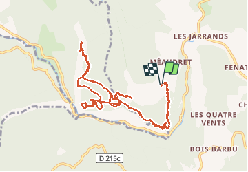
Trail Walking of 13.5 km to be discovered at Auvergne-Rhône-Alpes, Isère, Villard-de-Lans. This trail is proposed by nadd73.
Description
Se garer au Méaudret .en venant de Pont en Royans prendre les gorges de Bournes
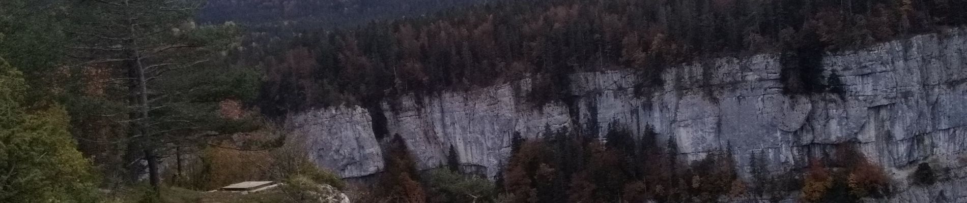
Très belle sente au dessus des falaises, avec des marques bleues, pour les crêtes de Ferrière.
Et jolie grotte: balme noire
Ne pas avoir peur du vide et avoir le pied sûr.
La partie au sud ouest est à éviter ou voir le Topos de Sombardier car nous n'avons pas trouvé le passage.
Positioning
Comments
Trails nearby
![Trail Snowshoes Autrans-Méaudre en Vercors - Le Gros Martel - Méaudre - Photo](https://media.geolcdn.com/t/375/260/ext.jpg?maxdim=2&url=https%3A%2F%2Fservices.sitytrail.com%2FGeolivesWS%2FDownloadMedia.ashx%3FTrailID%3D191341%26Media%3D14899_5.jpg)
![Snowshoes Snowshoes](https://static1.geolcdn.com/sitytour/trail-icons/504.png)
Snowshoes
![](/images/other/stat-length.png)
![](https://static1.geolcdn.com/siteimages/upload/files/16400158638029165_repeat_loop_refresh_sync_direction_icon.png)
![Trail Walking Villard-de-Lans - cabane de robon - Photo](https://media.geolcdn.com/t/375/260/f81b29b4-5a6d-4db9-85aa-f42275b30a70.jpg&format=jpg&maxdim=2)
![Walking Walking](https://static1.geolcdn.com/sitytour/trail-icons/101.png)
Walking
![](/images/other/stat-length.png)
![](https://static1.geolcdn.com/siteimages/upload/files/16400158638029165_repeat_loop_refresh_sync_direction_icon.png)
![Trail Walking Villard-de-Lans - Le sentier Peronnard et le Pas de l'OEille - Photo](https://media.geolcdn.com/t/375/260/ext.jpg?maxdim=2&url=https%3A%2F%2Fservices.sitytrail.com%2FGeolivesWS%2FDownloadMedia.ashx%3FTrailID%3D101509%26Media%3D1614_1.jpg)
![Walking Walking](https://static1.geolcdn.com/sitytour/trail-icons/101.png)
Walking
![](/images/other/stat-length.png)
![](https://static1.geolcdn.com/siteimages/upload/files/16400158638029165_repeat_loop_refresh_sync_direction_icon.png)
![Trail Walking Villard-de-Lans - Le Plateau du Cornafion 1906m - Photo](https://media.geolcdn.com/t/375/260/ext.jpg?maxdim=2&url=https%3A%2F%2Fservices.sitytrail.com%2FGeolivesWS%2FDownloadMedia.ashx%3FTrailID%3D101491%26Media%3D1596_1.jpg)
![Walking Walking](https://static1.geolcdn.com/sitytour/trail-icons/101.png)
Walking
![](/images/other/stat-length.png)
![](https://static1.geolcdn.com/siteimages/upload/files/16400158638029165_repeat_loop_refresh_sync_direction_icon.png)
![Trail Walking Rencurel - 38 vire bourne goule noire - Photo](https://media.geolcdn.com/t/375/260/62b6a30b-af4a-4e09-9d99-ed85f47fb4ae.jpg&format=jpg&maxdim=2)
![Walking Walking](https://static1.geolcdn.com/sitytour/trail-icons/101.png)
Walking
![](/images/other/stat-length.png)
![](https://static1.geolcdn.com/siteimages/upload/files/16400158638029165_repeat_loop_refresh_sync_direction_icon.png)
![Trail Walking Villard-de-Lans - 38 malaterre côté 2000 - Photo](https://media.geolcdn.com/t/375/260/f42b23e8-7328-4a7c-a1fa-911aa126df56.jpg&format=jpg&maxdim=2)
![Walking Walking](https://static1.geolcdn.com/sitytour/trail-icons/101.png)
Walking
![](/images/other/stat-length.png)
![](https://static1.geolcdn.com/siteimages/upload/files/16400158638029165_repeat_loop_refresh_sync_direction_icon.png)
![Trail On foot Rencurel - La Balme Noire par la vire de Haute Valette - Photo](https://media.geolcdn.com/t/375/260/ext.jpg?maxdim=2&url=https%3A%2F%2Fstatic1.geolcdn.com%2Fsiteimages%2Fupload%2Ffiles%2F1545311037marcheuse_200dpi.jpg)
![On foot On foot](https://static1.geolcdn.com/sitytour/trail-icons/100.png)
On foot
![](/images/other/stat-length.png)
![](https://static1.geolcdn.com/siteimages/upload/files/16400158638029165_repeat_loop_refresh_sync_direction_icon.png)
![Trail Walking Rencurel - 26 pas ferrière valchevriere - Photo](https://media.geolcdn.com/t/375/260/9dd39c24-ec71-4826-ac00-83cd7af45ed7.jpg&format=jpg&maxdim=2)
![Walking Walking](https://static1.geolcdn.com/sitytour/trail-icons/101.png)
Walking
![](/images/other/stat-length.png)
![](https://static1.geolcdn.com/siteimages/upload/files/16400158638029165_repeat_loop_refresh_sync_direction_icon.png)
![Trail Mountain bike Villard-de-Lans - Villars de Lans Vières Les Cochettes Balcon de Villard Clot de la Balme Correncon - Photo](https://media.geolcdn.com/t/375/260/ext.jpg?maxdim=2&url=https%3A%2F%2Fstatic1.geolcdn.com%2Fsiteimages%2Fupload%2Ffiles%2F1524743154velo.jpg)
![Mountain bike Mountain bike](https://static1.geolcdn.com/sitytour/trail-icons/202.png)
Mountain bike
![](/images/other/stat-length.png)
![](https://static1.geolcdn.com/siteimages/upload/files/16400158638029165_repeat_loop_refresh_sync_direction_icon.png)