Trail Walking Le Valtin - BELVEDERE DES 3 LACS (BOUCLE) - Photo

BELVEDERE DES 3 LACS (BOUCLE)

© OpenStreetMap contributors
Length
Length
8.5 km
Max alt
Max alt
1302 m
Uphill gradient
Uphill gradient
229 m
Km-Effort
Km-Effort  
11.5 km
Min alt
Min alt
1214 m
Downhill gradient
Downhill gradient
232 m
Boucle
Boucle
Yes
Creation date :
2020-10-20 13:18:34.062
Updated on :
2020-10-20 20:39:12.945

(0 Reviews)

Walking
Walking
2h17
Difficulty : Easy

Scan this QR Code to open this trail in the SityTrail application

FREE GPS app for hiking

Logo SityTrail SityTrail

IGN / Geographical institutes

Download SityTrail from the App Store Download SityTrail from Google Play

Logo SityTrail SityTrail World

The world is yours!

Download SityTrail from the App Store Download SityTrail from Google Play Download SityTrail on Huawei AppGallery

About

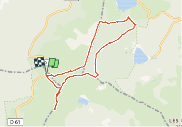
Trail Walking of 8.5 km to be discovered at Grand Est, Vosges, Le Valtin. This trail is proposed by surceneux.

Description

GAZON DU FAING AUBERGE SOULTZERER ECK TAUBENKLANGFELSEN LAC DES TRUITES LAC NOIR BELMONT LAC BLANC HTES CHAUMES GAZON DU FAING

Elevation profile

Positioning

Country:
France
Region :
Grand Est
Department/Province :
Vosges
Municipality :
Le Valtin
Location:
Unknown
Start:(UTM)
355952 ; 5330208 (32U) N.

Trails nearby

Trail Walking Le Valtin - Les Rochers des Hirschsteine - Lac Vert - Photo
Walking
GUIDE
Michel1963

Walking

Difficult
(2)
Le Valtin, Grand Est, Vosges, France
14.4 km | 22 km-effort
5h 2min
Yes
Trail Horseback riding Orbey - 2020-06-28 WE Orbey Petit Hohnack Glasborn - Photo
Horseback riding
GUIDE
holtzv

Horseback riding

Difficult
(1)
Orbey, Grand Est, Haut-Rhin, France
22 km | 31 km-effort
4h 5min
Yes
Trail Horseback riding Orbey - 2020-06-27 WE Orbey Noir Gazon Vert Forlet - Photo
Horseback riding
GUIDE
holtzv

Horseback riding

Medium
(1)
Orbey, Grand Est, Haut-Rhin, France
21 km | 30 km-effort
3h 59min
Yes
Trail Walking Le Valtin - Le Sentier des Roches - Photo
Walking
GUIDE
Michel1963

Walking

Difficult
(2)
Le Valtin, Grand Est, Vosges, France
20 km | 34 km-effort
7h 43min
Yes
Trail Walking Stosswihr - Tour du belvedere avec le passage sur les crêtes  - Photo
Walking
ocepee

Walking

Very easy
(2)
Stosswihr, Grand Est, Haut-Rhin, France
8.5 km | 0 m-effort
2h 28min
Yes
Trail Other activity Soultzeren - Totom 4 lacs - Photo
Other activity
dinozore

Other activity

Medium
(1)
Soultzeren, Grand Est, Haut-Rhin, France
15.6 km | 26 km-effort
4h 37min
Yes
Trail Walking Hohrod - Circuit historique 1914-18 Hohrodberg - Linge - Photo
Walking
VacheKiri67

Walking

Medium
(1)
Hohrod, Grand Est, Haut-Rhin, France
14 km | 19.8 km-effort
5h 50min
Yes
Trail Walking Le Valtin - Les Hirschsteine - Photo
Walking
VacheKiri67

Walking

Difficult
(1)
Le Valtin, Grand Est, Vosges, France
16.1 km | 25 km-effort
6h 28min
Yes
Trail Walking Orbey - Le Tour du Lac Blanc par le Rocher Hans et le sentier de crête - Photo
Walking
tracegps

Walking

Difficult
(3)
Orbey, Grand Est, Haut-Rhin, France
4.4 km | 7.7 km-effort
2h 30min
Yes


Close
My subscriptions