Trail On foot Saint-Nizier-du-Moucherotte - Vercors jour 2: Bivouac 1 à Bivouac 2 - Photo

Vercors jour 2: Bivouac 1 à Bivouac 2

© OpenStreetMap contributors
Length
Length
27 km
Max alt
Max alt
1567 m
Uphill gradient
Uphill gradient
904 m
Km-Effort
Km-Effort  
39 km
Min alt
Min alt
1088 m
Downhill gradient
Downhill gradient
1041 m
Boucle
Boucle
No
Creation date :
2020-10-20 09:51:44.371
Updated on :
2020-10-20 10:06:53.875

(0 Reviews)

On foot
On foot
--
Difficulty : Difficult

Scan this QR Code to open this trail in the SityTrail application

FREE GPS app for hiking

Logo SityTrail SityTrail

IGN / Geographical institutes

Download SityTrail from the App Store Download SityTrail from Google Play

Logo SityTrail SityTrail World

The world is yours!

Download SityTrail from the App Store Download SityTrail from Google Play Download SityTrail on Huawei AppGallery

About

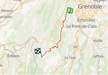
Trail On foot of 27 km to be discovered at Auvergne-Rhône-Alpes, Isère, Saint-Nizier-du-Moucherotte. This trail is proposed by MathieuBourgois.

Description

Allières 9km et 460 D
Les Clots 18km et 660D
Les Bouchards 23km et 800 D
Corrençon en Vercors 25km et 800D
Bivouac  27km et 900D

Elevation profile

Positioning

Country:
France
Region :
Auvergne-Rhône-Alpes
Department/Province :
Isère
Municipality :
Saint-Nizier-du-Moucherotte
Location:
Unknown
Start:(UTM)
706431 ; 5003258 (31T) N.

Trails nearby

Trail Nordic walking Seyssins - Seyssins le haut - Les Arcelles dans la neige - Photo
Nordic walking
patjobou

Nordic walking

Medium
(1)
Seyssins, Auvergne-Rhône-Alpes, Isère, France
9.1 km | 13.8 km-effort
2h 45min
Yes
Trail Walking Engins - Circuit pas de la Lose, du Tracollet, de l'Ours avec un retour par le passage  de la Grande Combe - Photo
Walking
Emelle

Walking

Medium
(3)
Engins, Auvergne-Rhône-Alpes, Isère, France
10.9 km | 21 km-effort
5h 12min
Yes
Trail Walking Seyssins - MOUCHEROTTE - Photo
Walking
Ninie38MD

Walking

Difficult
(1)
Seyssins, Auvergne-Rhône-Alpes, Isère, France
20 km | 40 km-effort
8h 9min
Yes
Trail Snowshoes Lans-en-Vercors - La Crête des Ramées de nuit en raquettes - Photo
Snowshoes
patjobou

Snowshoes

Medium
(1)
Lans-en-Vercors, Auvergne-Rhône-Alpes, Isère, France
8 km | 13.4 km-effort
4h 9min
Yes
Trail Walking Lans-en-Vercors - Le Pic saint michel - Photo
Walking
patjobou

Walking

Easy
(1)
Lans-en-Vercors, Auvergne-Rhône-Alpes, Isère, France
6.5 km | 13.2 km-effort
2h 38min
No
Trail Walking Lans-en-Vercors - le vertige des cimes - Photo
Walking
jeanfcd

Walking

Medium
(1)
Lans-en-Vercors, Auvergne-Rhône-Alpes, Isère, France
6.3 km | 11 km-effort
2h 9min
Yes
Trail Mountain bike Seyssins - Petite escapade électrique au-dessus de 38 Seyssins - Photo
Mountain bike
patjobou

Mountain bike

Easy
(1)
Seyssins, Auvergne-Rhône-Alpes, Isère, France
12.3 km | 19.7 km-effort
1h 29min
Yes
Trail Walking Fontaine - M le 20 cabane de Laura - Photo
Walking
Ninie38MD

Walking

Difficult
(1)
Fontaine, Auvergne-Rhône-Alpes, Isère, France
16.8 km | 30 km-effort
6h 59min
Yes
Trail Walking Lans-en-Vercors - Lans - Belvédère Vertige des Cimes depuis Le Furon - Photo
Walking
patjobou

Walking

Medium
(1)
Lans-en-Vercors, Auvergne-Rhône-Alpes, Isère, France
8 km | 15.9 km-effort
3h 9min
Yes


Close
My subscriptions