Trail On foot Tende - Alpes jour 21 : Refuge de Merveilles à Cabane vieille bivouac - Photo

Alpes jour 21 : Refuge de Merveilles à Cabane vieille bivouac

© OpenStreetMap contributors
Length
Length
17.9 km
Max alt
Max alt
2436 m
Uphill gradient
Uphill gradient
771 m
Km-Effort
Km-Effort  
29 km
Min alt
Min alt
1695 m
Downhill gradient
Downhill gradient
1087 m
Boucle
Boucle
No
Creation date :
2020-10-20 07:17:35.031
Updated on :
2020-10-20 07:30:50.936

(0 Reviews)

On foot
On foot
--
Difficulty : Difficult

Scan this QR Code to open this trail in the SityTrail application

FREE GPS app for hiking

Logo SityTrail SityTrail

IGN / Geographical institutes

Download SityTrail from the App Store Download SityTrail from Google Play

Logo SityTrail SityTrail World

The world is yours!

Download SityTrail from the App Store Download SityTrail from Google Play Download SityTrail on Huawei AppGallery

About

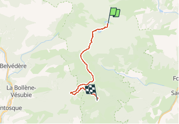
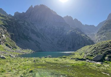
Trail On foot of 17.9 km to be discovered at Provence-Alpes-Côte d'Azur, Maritime Alps, Tende. This trail is proposed by MathieuBourgois.

Description

Pas du Diable 3.6km et 310D
Col de Raus 6.4km et 340D
Pointe des trois communes 10km et 560D
Baisse du camp d'Argent 13km et 580D
Cabane vieille 18km et 730D
Bivouac 18km et 770D

Elevation profile

Positioning

Country:
France
Region :
Provence-Alpes-Côte d'Azur
Department/Province :
Maritime Alps
Municipality :
Tende
Location:
Unknown
Start:(UTM)
375995 ; 4879412 (32T) N.

Trails nearby

Trail Walking Tende - 83 fontanalba lac des mesches - Photo
Walking
GUIDE
randodyssée

Walking

Medium
Tende, Provence-Alpes-Côte d'Azur, Maritime Alps, France
11.6 km | 19.6 km-effort
5h 19min
No
Trail On foot Tende - Vallée des Merveilles - Photo
On foot
GUIDE+

On foot

Difficult
(1)
Tende, Provence-Alpes-Côte d'Azur, Maritime Alps, France
22 km | 36 km-effort
8h 6min
Yes
Trail On foot Tende - Circuit de Fontanalbe - Photo
On foot
GUIDE+

On foot

Medium
Tende, Provence-Alpes-Côte d'Azur, Maritime Alps, France
14.6 km | 24 km-effort
5h 28min
Yes
Trail On foot Tende - Tour du Grand Capelet - Etape 3 - Photo
On foot
GUIDE+

On foot

Easy
Tende, Provence-Alpes-Côte d'Azur, Maritime Alps, France
6.4 km | 12.9 km-effort
2h 56min
No
Trail On foot Belvédère - Les Merveilles par la Gordolasque - Photo
On foot
GUIDE+

On foot

Medium
Belvédère, Provence-Alpes-Côte d'Azur, Maritime Alps, France
13 km | 29 km-effort
6h 35min
Yes
Trail Walking Tende - Casterino - Fontanalba - 2016 06 20 - Photo
Walking
GUIDE
Orcal37

Walking

Difficult
Tende, Provence-Alpes-Côte d'Azur, Maritime Alps, France
16.8 km | 27 km-effort
6h 35min
Yes
Trail Walking Belvédère - Tête Nord du Basto  - Photo
Walking
bozo1970

Walking

Very difficult
Belvédère, Provence-Alpes-Côte d'Azur, Maritime Alps, France
10.4 km | 25 km-effort
5h 42min
Yes
Trail Walking Belvédère - Cime Niré - Photo
Walking
bozo1970

Walking

Very difficult
Belvédère, Provence-Alpes-Côte d'Azur, Maritime Alps, France
9.3 km | 22 km-effort
4h 55min
Yes
Trail Walking Tende - caterino - Photo
Walking
RoMo

Walking

Difficult
Tende, Provence-Alpes-Côte d'Azur, Maritime Alps, France
15.7 km | 26 km-effort
4h 47min
Yes


Close
My subscriptions