![](/images/other/stat-length.png)
![Trail On foot Roure - Alpes jour 17: Refuge de Longon à - Photo](https://media.geolcdn.com/t/1900/400/ext.pjpeg?maxdim=2&url=https%3A%2F%2Fstatic1.geolcdn.com%2Fsiteimages%2Fupload%2Ffiles%2F1545311037marcheuse_200dpi.jpg)
Alpes jour 17: Refuge de Longon à
MathieuBourgois
User
![Length](/images/other/stat-length.png)
Length
24 km
![Max alt](https://static1.geolcdn.com/siteimages/upload/files/1508320355ic_sort_altitude_max_24dp.png)
Max alt
1890 m
![Uphill gradient](https://static1.geolcdn.com/siteimages/upload/files/1508320355ic_sort_den_pos_24dp.png)
Uphill gradient
1119 m
![Km-Effort](/images/other/stat-length.png)
Km-Effort
41 km
![Min alt](https://static1.geolcdn.com/siteimages/upload/files/1508320355ic_sort_altitude_min_24dp.png)
Min alt
488 m
![Downhill gradient](https://static1.geolcdn.com/siteimages/upload/files/1508320355ic_sort_den_neg_24dp.png)
Downhill gradient
1725 m
![Boucle](https://static1.geolcdn.com/siteimages/upload/files/16400158638029165_repeat_loop_refresh_sync_direction_icon.png)
Boucle
No
Creation date :
2020-10-19 12:20:59.353
Updated on :
2020-10-19 12:31:14.084
![On foot](https://static1.geolcdn.com/sitytour/trail-icons/100.png)
--
Difficulty : Medium
![Scan this QR Code to open this trail in the SityTrail application](https://capi.geolives.com/qq0zvz2zws4bq2lad0pu/sitytour/trails/2581857/qr.png?size=200)
FREE GPS app for hiking
About
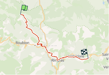
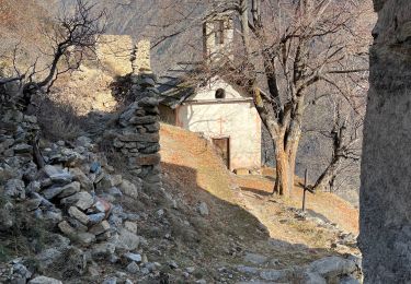
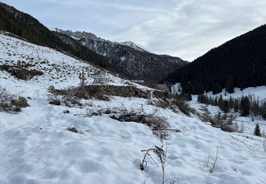
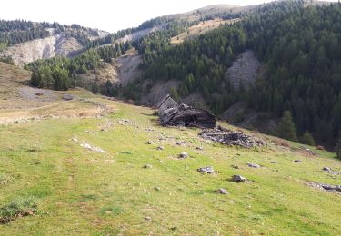
Trail On foot of 24 km to be discovered at Provence-Alpes-Côte d'Azur, Maritime Alps, Roure. This trail is proposed by MathieuBourgois.
Description
Rogios 3.5km et 0D
Roure 9km et 90D
St Sauver le Tinée 13km et 100D
Rimplas 18km et 650D
Saint Delmas Valdeblore 24km et 1100D
Positioning
Country:
France
Region :
Provence-Alpes-Côte d'Azur
Department/Province :
Maritime Alps
Municipality :
Roure
Location:
Unknown
Start:(Dec)
Start:(UTM)
343788 ; 4889187 (32T) N.
Comments
Trails nearby
![Trail On foot Beuil - Tête du Garnier - Photo](https://media.geolcdn.com/t/375/260/8afc2979-1909-4f36-ba82-f331af4dab5f.jpeg&format=jpg&maxdim=2)
![On foot On foot](https://static1.geolcdn.com/sitytour/trail-icons/100.png)
Tête du Garnier
On foot
Easy
Beuil,
Provence-Alpes-Côte d'Azur,
Maritime Alps,
France
![](/images/other/stat-length.png)
11.2 km | 17.8 km-effort
4h 3min
![](https://static1.geolcdn.com/siteimages/upload/files/16400158638029165_repeat_loop_refresh_sync_direction_icon.png)
Yes
![Trail Walking Roure - Mont Autcellier - Photo](https://media.geolcdn.com/t/375/260/ext.jpg?maxdim=2&url=https%3A%2F%2Fstatic1.geolcdn.com%2Fsiteimages%2Fupload%2Ffiles%2F1553511878bg_sport_marche.png)
![Walking Walking](https://static1.geolcdn.com/sitytour/trail-icons/101.png)
Mont Autcellier
Walking
Easy
(1)
Roure,
Provence-Alpes-Côte d'Azur,
Maritime Alps,
France
![](/images/other/stat-length.png)
18 km | 31 km-effort
5h 48min
![](https://static1.geolcdn.com/siteimages/upload/files/16400158638029165_repeat_loop_refresh_sync_direction_icon.png)
Yes
![Trail Snowshoes Roubion - Couillole Mt Brussière - Photo](https://media.geolcdn.com/t/375/260/ext.jpg?maxdim=2&url=https%3A%2F%2Fstatic1.geolcdn.com%2Fsiteimages%2Fupload%2Ffiles%2F1524743153raquette.jpg)
![Snowshoes Snowshoes](https://static1.geolcdn.com/sitytour/trail-icons/504.png)
Couillole Mt Brussière
Snowshoes
Easy
(2)
Roubion,
Provence-Alpes-Côte d'Azur,
Maritime Alps,
France
![](/images/other/stat-length.png)
5 km | 8.6 km-effort
2h 0min
![](https://static1.geolcdn.com/siteimages/upload/files/16400158638029165_repeat_loop_refresh_sync_direction_icon.png)
Yes
![Trail Walking Roure - Refuge et Porte de Longon, circuit de Vignols, Roure J2 - Photo](https://media.geolcdn.com/t/375/260/540a5490-f7bf-467f-96eb-f85eb4f7a9b2.jpg&format=jpg&maxdim=2)
![Walking Walking](https://static1.geolcdn.com/sitytour/trail-icons/101.png)
Refuge et Porte de Longon, circuit de Vignols, Roure J2
Walking
Medium
Roure,
Provence-Alpes-Côte d'Azur,
Maritime Alps,
France
![](/images/other/stat-length.png)
19.6 km | 28 km-effort
5h 8min
![](https://static1.geolcdn.com/siteimages/upload/files/16400158638029165_repeat_loop_refresh_sync_direction_icon.png)
No
![Trail Walking Roure - Mont Autcellier de Roure au Refuge Longon J1 - Photo](https://media.geolcdn.com/t/375/260/3e2b7523-9380-4de0-91b2-f4360a9e4c37.jpg&format=jpg&maxdim=2)
![Walking Walking](https://static1.geolcdn.com/sitytour/trail-icons/101.png)
Mont Autcellier de Roure au Refuge Longon J1
Walking
Medium
Roure,
Provence-Alpes-Côte d'Azur,
Maritime Alps,
France
![](/images/other/stat-length.png)
10 km | 19.2 km-effort
4h 21min
![](https://static1.geolcdn.com/siteimages/upload/files/16400158638029165_repeat_loop_refresh_sync_direction_icon.png)
No
![Trail Walking Roure - Mont Gravières - Photo](https://media.geolcdn.com/t/375/260/7bdeb2b5-b8d8-4157-9e7e-877f3bedfb93.jpg&format=jpg&maxdim=2)
![Walking Walking](https://static1.geolcdn.com/sitytour/trail-icons/101.png)
Mont Gravières
Walking
Very difficult
Roure,
Provence-Alpes-Côte d'Azur,
Maritime Alps,
France
![](/images/other/stat-length.png)
13.4 km | 26 km-effort
4h 22min
![](https://static1.geolcdn.com/siteimages/upload/files/16400158638029165_repeat_loop_refresh_sync_direction_icon.png)
Yes
![Trail Walking Roure - Hameau de Valabres - Photo](https://media.geolcdn.com/t/375/260/56a3b635-c267-4747-9bb0-6892756b86fd.jpg&format=jpg&maxdim=2)
![Walking Walking](https://static1.geolcdn.com/sitytour/trail-icons/101.png)
Hameau de Valabres
Walking
Medium
Roure,
Provence-Alpes-Côte d'Azur,
Maritime Alps,
France
![](/images/other/stat-length.png)
12.5 km | 27 km-effort
4h 16min
![](https://static1.geolcdn.com/siteimages/upload/files/16400158638029165_repeat_loop_refresh_sync_direction_icon.png)
Yes
![Trail Walking Saint-Sauveur-sur-Tinée - Mollières Hiver - Photo](https://media.geolcdn.com/t/375/260/fd916d3a-a875-4f9a-8619-c33e52e39e88.jpg&format=jpg&maxdim=2)
![Walking Walking](https://static1.geolcdn.com/sitytour/trail-icons/101.png)
Mollières Hiver
Walking
Very difficult
Saint-Sauveur-sur-Tinée,
Provence-Alpes-Côte d'Azur,
Maritime Alps,
France
![](/images/other/stat-length.png)
18 km | 31 km-effort
5h 1min
![](https://static1.geolcdn.com/siteimages/upload/files/16400158638029165_repeat_loop_refresh_sync_direction_icon.png)
Yes
![Trail Walking Roubion - Col Couillole Ars Buissieres - Photo](https://media.geolcdn.com/t/375/260/d9dfd427-66e0-4f76-9cbe-45690c064ed5.jpg&format=jpg&maxdim=2)
![Walking Walking](https://static1.geolcdn.com/sitytour/trail-icons/101.png)
Col Couillole Ars Buissieres
Walking
Easy
Roubion,
Provence-Alpes-Côte d'Azur,
Maritime Alps,
France
![](/images/other/stat-length.png)
10.5 km | 17.3 km-effort
3h 30min
![](https://static1.geolcdn.com/siteimages/upload/files/16400158638029165_repeat_loop_refresh_sync_direction_icon.png)
Yes