![](/images/other/stat-length.png)
![Trail Walking Recloses - GLM-140312 - Recloses-Jauberton - Photo](https://media.geolcdn.com/t/1900/400/ext.pjpeg?maxdim=2&url=https%3A%2F%2Fservices.sitytrail.com%2FGeolivesWS%2FDownloadMedia.ashx%3FTrailID%3D258014%26Media%3D25585dee-39bf-4091-a428-9f4ce3643be5.jpg)
GLM-140312 - Recloses-Jauberton
randodan
User
![Length](/images/other/stat-length.png)
![Max alt](https://static1.geolcdn.com/siteimages/upload/files/1508320355ic_sort_altitude_max_24dp.png)
![Uphill gradient](https://static1.geolcdn.com/siteimages/upload/files/1508320355ic_sort_den_pos_24dp.png)
![Km-Effort](/images/other/stat-length.png)
![Min alt](https://static1.geolcdn.com/siteimages/upload/files/1508320355ic_sort_altitude_min_24dp.png)
![Downhill gradient](https://static1.geolcdn.com/siteimages/upload/files/1508320355ic_sort_den_neg_24dp.png)
![Boucle](https://static1.geolcdn.com/siteimages/upload/files/16400158638029165_repeat_loop_refresh_sync_direction_icon.png)
![Walking](https://static1.geolcdn.com/sitytour/trail-icons/101.png)
5h00
Difficulty : Easy
![Scan this QR Code to open this trail in the SityTrail application](https://capi.geolives.com/qq0zvz2zws4bq2lad0pu/sitytour/trails/258014/qr.png?size=200)
FREE GPS app for hiking
About
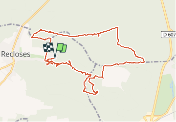
Trail Walking of 13.1 km to be discovered at Ile-de-France, Seine-et-Marne, Recloses. This trail is proposed by randodan.
Description
Cavités et Jonquilles à Recloses et Jauberton avec les Gais Lurons du Mercredi<br>- 12 mars 2014 -<br>
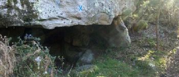
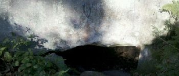
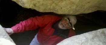
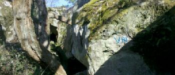
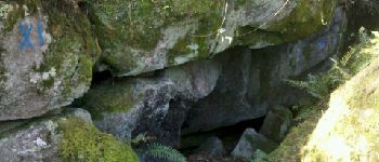
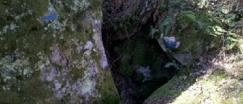
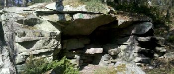
Départ 9h . Explorons un bon nombre de cavités dont la Faille du Petit Puits (XI) et l´Abri des Francs (XVI) . Obélix et la Roche Pointue (XVII), c´est pour les grimpeurs.<br>
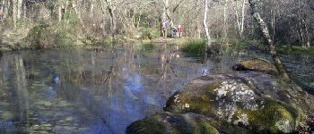
Pause chamallows à la Mare Marcou ; puis la recherche d'un raccourci nous amène à crapahuter sur une bute bien raide avant de contourner la Sablière de Bourron, bien ensoleillée.<br>
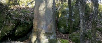
La Vallée Jauberton, en RBI, une forêt laissée à la nature.<br>
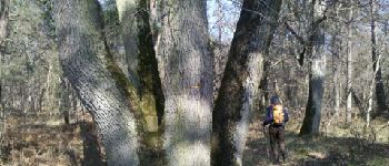
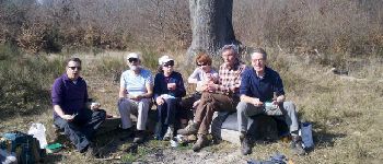
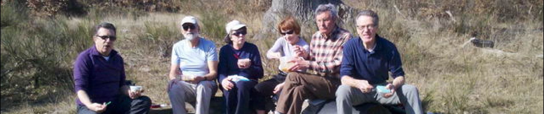
13h, nous sortons le pique-nique au pied d´un impressionnant chêne sessile à 4 (5-1) tiges . Le "Pop !" du Coulanges-la-Vineuse 2011 salue Jean-Claude de retour avec Geneviève.<br>
L´après-midi, c'est direct la Route de la Génisse, où chacun se confectionne son bouquet de jonquilles.<br>
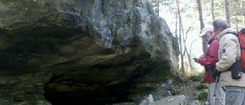
La balade dans les rochers du matin ayant fatigué bien des jambes, la majorité préfère rentrer plutôt que rallonger par l’Abri des Francs.<br>
15h20 au parking . Très belle journée de printemps avant la date.<br>
7 participants.
Points of interest
Positioning
Comments
Trails nearby
![Trail Walking Recloses - Boucle recloses Nemours Grez/loing - Photo](https://media.geolcdn.com/t/375/260/191d15c7-1e16-40f7-89b9-dd7f9d0cddba.jpg&format=jpg&maxdim=2)
![Walking Walking](https://static1.geolcdn.com/sitytour/trail-icons/101.png)
Walking
![](/images/other/stat-length.png)
![](https://static1.geolcdn.com/siteimages/upload/files/16400158638029165_repeat_loop_refresh_sync_direction_icon.png)
![Trail Walking Bourron-Marlotte - Boucle Bourron Marlotte ( reco Didier) - Photo](https://media.geolcdn.com/t/375/260/ext.jpg?maxdim=2&url=https%3A%2F%2Fstatic1.geolcdn.com%2Fsiteimages%2Fupload%2Ffiles%2F1553511878bg_sport_marche.png)
![Walking Walking](https://static1.geolcdn.com/sitytour/trail-icons/101.png)
Walking
![](/images/other/stat-length.png)
![](https://static1.geolcdn.com/siteimages/upload/files/16400158638029165_repeat_loop_refresh_sync_direction_icon.png)
![Trail Walking Fontainebleau - Rocher Fourceau-Petit Mont Chauvet SR210523Ve?? fmg - Photo](https://media.geolcdn.com/t/375/260/cabc9437-0e04-4fa0-9f5b-0c9f73ac9000.jpg&format=jpg&maxdim=2)
![Walking Walking](https://static1.geolcdn.com/sitytour/trail-icons/101.png)
Walking
![](/images/other/stat-length.png)
![](https://static1.geolcdn.com/siteimages/upload/files/16400158638029165_repeat_loop_refresh_sync_direction_icon.png)
![Trail Walking Fontainebleau - Sentier Denecourt N°9 Rocher des Demoiselles - Photo](https://media.geolcdn.com/t/375/260/ext.jpg?maxdim=2&url=https%3A%2F%2Fstatic1.geolcdn.com%2Fsiteimages%2Fupload%2Ffiles%2F1553511878bg_sport_marche.png)
![Walking Walking](https://static1.geolcdn.com/sitytour/trail-icons/101.png)
Walking
![](/images/other/stat-length.png)
![](https://static1.geolcdn.com/siteimages/upload/files/16400158638029165_repeat_loop_refresh_sync_direction_icon.png)
![Trail On foot Bourron-Marlotte - Boucle 30 km Bourron Marlotte - Montigny/ Loing / Grez - Photo](https://media.geolcdn.com/t/375/260/04503fe2-d147-4df8-acdc-18641722dd77.jpg&format=jpg&maxdim=2)
![On foot On foot](https://static1.geolcdn.com/sitytour/trail-icons/100.png)
On foot
![](/images/other/stat-length.png)
![](https://static1.geolcdn.com/siteimages/upload/files/16400158638029165_repeat_loop_refresh_sync_direction_icon.png)
![Trail Walking Fontainebleau - Boucle 20 km Fontainebleau vert galant - Photo](https://media.geolcdn.com/t/375/260/81db76b1-13eb-40e0-aee9-8545465c0b96.jpg&format=jpg&maxdim=2)
![Walking Walking](https://static1.geolcdn.com/sitytour/trail-icons/101.png)
Walking
![](/images/other/stat-length.png)
![](https://static1.geolcdn.com/siteimages/upload/files/16400158638029165_repeat_loop_refresh_sync_direction_icon.png)
![Trail On foot Fontainebleau - Promenade de la Gorge aux Archers - Photo](https://media.geolcdn.com/t/375/260/206595bb-a11d-45f9-a4c6-c076bd451921.jpeg&format=jpg&maxdim=2)
![On foot On foot](https://static1.geolcdn.com/sitytour/trail-icons/100.png)
On foot
![](/images/other/stat-length.png)
![](https://static1.geolcdn.com/siteimages/upload/files/16400158638029165_repeat_loop_refresh_sync_direction_icon.png)
![Trail Walking Bourron-Marlotte - Les rochers de Recloses par Bourron Marlotte - Photo](https://media.geolcdn.com/t/375/260/ext.jpg?maxdim=2&url=https%3A%2F%2Fstatic1.geolcdn.com%2Fsiteimages%2Fupload%2Ffiles%2F1553511878bg_sport_marche.png)
![Walking Walking](https://static1.geolcdn.com/sitytour/trail-icons/101.png)
Walking
![](/images/other/stat-length.png)
![](https://static1.geolcdn.com/siteimages/upload/files/16400158638029165_repeat_loop_refresh_sync_direction_icon.png)
![Trail Walking Fontainebleau - Forêt de Fontainebleau (Achères) 240414 - Photo](https://media.geolcdn.com/t/375/260/977f0351-b4cc-4726-9426-524435e32e7d.jpg&format=jpg&maxdim=2)
![Walking Walking](https://static1.geolcdn.com/sitytour/trail-icons/101.png)
Walking
![](/images/other/stat-length.png)
![](https://static1.geolcdn.com/siteimages/upload/files/16400158638029165_repeat_loop_refresh_sync_direction_icon.png)