


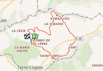

7.6 km | 9.9 km-effort


User


FREE GPS app for hiking
 SityTrail
IGN / Geographical institutes
SityTrail World
The world is yours!
Trail On foot of 9.4 km to be discovered at Occitania, Tarn, Terre-de-Bancalié. This trail is proposed by tercla.
Walking


sport

On foot

Walking
Walking
Walking
belle randonnée