![](/images/other/stat-length.png)
![Trail On foot Aiguilles - Alpes jour 11: Aiguilles à Ceillac - Photo](https://media.geolcdn.com/t/1900/400/ext.pjpeg?maxdim=2&url=https%3A%2F%2Fstatic1.geolcdn.com%2Fsiteimages%2Fupload%2Ffiles%2F1545311037marcheuse_200dpi.jpg)
Alpes jour 11: Aiguilles à Ceillac
MathieuBourgois
User
![Length](/images/other/stat-length.png)
Length
23 km
![Max alt](https://static1.geolcdn.com/siteimages/upload/files/1508320355ic_sort_altitude_max_24dp.png)
Max alt
2315 m
![Uphill gradient](https://static1.geolcdn.com/siteimages/upload/files/1508320355ic_sort_den_pos_24dp.png)
Uphill gradient
1349 m
![Km-Effort](/images/other/stat-length.png)
Km-Effort
40 km
![Min alt](https://static1.geolcdn.com/siteimages/upload/files/1508320355ic_sort_altitude_min_24dp.png)
Min alt
1346 m
![Downhill gradient](https://static1.geolcdn.com/siteimages/upload/files/1508320355ic_sort_den_neg_24dp.png)
Downhill gradient
1173 m
![Boucle](https://static1.geolcdn.com/siteimages/upload/files/16400158638029165_repeat_loop_refresh_sync_direction_icon.png)
Boucle
No
Creation date :
2020-10-16 12:01:29.601
Updated on :
2021-06-01 12:41:52.327
![On foot](https://static1.geolcdn.com/sitytour/trail-icons/100.png)
--
Difficulty : Medium
![Scan this QR Code to open this trail in the SityTrail application](https://capi.geolives.com/qq0zvz2zws4bq2lad0pu/sitytour/trails/2578778/qr.png?size=200)
FREE GPS app for hiking
About
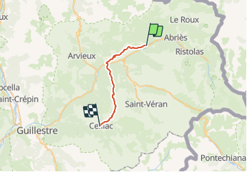
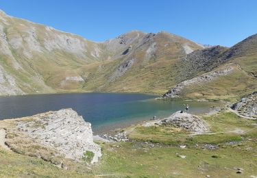
Trail On foot of 23 km to be discovered at Provence-Alpes-Côte d'Azur, Hautes-Alpes, Aiguilles. This trail is proposed by MathieuBourgois.
Description
Passage du GR(! au GR5
Château Queyras 9.5km et 350D
Col du fromage 18km et 1350D
Le Villard 21km et 1350D
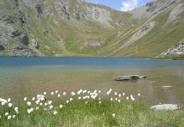
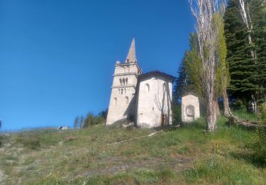
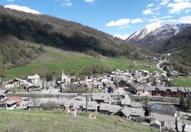
Ceillac 23km et 1350D
Positioning
Country:
France
Region :
Provence-Alpes-Côte d'Azur
Department/Province :
Hautes-Alpes
Municipality :
Aiguilles
Location:
Unknown
Start:(Dec)
Start:(UTM)
331473 ; 4960852 (32T) N.
Comments
Trails nearby
![Trail Walking Château-Ville-Vieille - Queyras j1 - Photo](https://media.geolcdn.com/t/375/260/78b4351d-2aa3-4d9e-84af-a2a8af3e275c.jpg&format=jpg&maxdim=2)
![Walking Walking](https://static1.geolcdn.com/sitytour/trail-icons/101.png)
Queyras j1
Walking
Medium
(1)
Château-Ville-Vieille,
Provence-Alpes-Côte d'Azur,
Hautes-Alpes,
France
![](/images/other/stat-length.png)
19.1 km | 36 km-effort
8h 6min
![](https://static1.geolcdn.com/siteimages/upload/files/16400158638029165_repeat_loop_refresh_sync_direction_icon.png)
No
![Trail Walking Château-Ville-Vieille - Ville-vieille - Ceillac - Photo](https://media.geolcdn.com/t/375/260/ext.jpg?maxdim=2&url=https%3A%2F%2Fservices.sitytrail.com%2FGeolivesWS%2FDownloadMedia.ashx%3FTrailID%3D629864%26Media%3Dfix__20160909131710.jpg)
![Walking Walking](https://static1.geolcdn.com/sitytour/trail-icons/101.png)
Ville-vieille - Ceillac
Walking
Medium
Château-Ville-Vieille,
Provence-Alpes-Côte d'Azur,
Hautes-Alpes,
France
![](/images/other/stat-length.png)
17.4 km | 31 km-effort
6h 51min
![](https://static1.geolcdn.com/siteimages/upload/files/16400158638029165_repeat_loop_refresh_sync_direction_icon.png)
No
![Trail Walking Abriès-Ristolas - Abriès - Aiguilles - Photo](https://media.geolcdn.com/t/375/260/ext.jpg?maxdim=2&url=https%3A%2F%2Fservices.sitytrail.com%2FGeolivesWS%2FDownloadMedia.ashx%3FTrailID%3D629859%26Media%3Dfix__20160907131116.jpg)
![Walking Walking](https://static1.geolcdn.com/sitytour/trail-icons/101.png)
Abriès - Aiguilles
Walking
Difficult
Abriès-Ristolas,
Provence-Alpes-Côte d'Azur,
Hautes-Alpes,
France
![](/images/other/stat-length.png)
16.9 km | 32 km-effort
7h 19min
![](https://static1.geolcdn.com/siteimages/upload/files/16400158638029165_repeat_loop_refresh_sync_direction_icon.png)
No
![Trail Walking Abriès-Ristolas - Abriès - Aiguilles - Photo](https://media.geolcdn.com/t/375/260/ext.jpg?maxdim=2&url=https%3A%2F%2Fservices.sitytrail.com%2FGeolivesWS%2FDownloadMedia.ashx%3FTrailID%3D629858%26Media%3Dfix__20160907131116.jpg)
![Walking Walking](https://static1.geolcdn.com/sitytour/trail-icons/101.png)
Abriès - Aiguilles
Walking
Difficult
Abriès-Ristolas,
Provence-Alpes-Côte d'Azur,
Hautes-Alpes,
France
![](/images/other/stat-length.png)
16.9 km | 32 km-effort
7h 19min
![](https://static1.geolcdn.com/siteimages/upload/files/16400158638029165_repeat_loop_refresh_sync_direction_icon.png)
No
![Trail Walking Aiguilles - les lacs du Malrifs - Photo](https://media.geolcdn.com/t/375/260/ext.jpg?maxdim=2&url=https%3A%2F%2Fservices.sitytrail.com%2FGeolivesWS%2FDownloadMedia.ashx%3FTrailID%3D445852%26Media%3Dfix__20150715135638.jpg)
![Walking Walking](https://static1.geolcdn.com/sitytour/trail-icons/101.png)
les lacs du Malrifs
Walking
Very easy
Aiguilles,
Provence-Alpes-Côte d'Azur,
Hautes-Alpes,
France
![](/images/other/stat-length.png)
11 km | 21 km-effort
4h 44min
![](https://static1.geolcdn.com/siteimages/upload/files/16400158638029165_repeat_loop_refresh_sync_direction_icon.png)
Yes
![Trail Walking Abriès-Ristolas - ABRIES - Photo](https://media.geolcdn.com/t/375/260/95105ed2-aa76-467e-a649-7d2ce80aa1e2.jpg&format=jpg&maxdim=2)
![Walking Walking](https://static1.geolcdn.com/sitytour/trail-icons/101.png)
ABRIES
Walking
Medium
Abriès-Ristolas,
Provence-Alpes-Côte d'Azur,
Hautes-Alpes,
France
![](/images/other/stat-length.png)
9 km | 14.7 km-effort
3h 5min
![](https://static1.geolcdn.com/siteimages/upload/files/16400158638029165_repeat_loop_refresh_sync_direction_icon.png)
Yes
![Trail Walking Abriès-Ristolas - Malrif à partir de Abries - Photo](https://media.geolcdn.com/t/375/260/2962a407-1b8d-4c1a-aa47-69b94a8a67a9.jpg&format=jpg&maxdim=2)
![Walking Walking](https://static1.geolcdn.com/sitytour/trail-icons/101.png)
Malrif à partir de Abries
Walking
Medium
Abriès-Ristolas,
Provence-Alpes-Côte d'Azur,
Hautes-Alpes,
France
![](/images/other/stat-length.png)
9.8 km | 17.1 km-effort
3h 36min
![](https://static1.geolcdn.com/siteimages/upload/files/16400158638029165_repeat_loop_refresh_sync_direction_icon.png)
Yes
![Trail Walking Aiguilles - lacs malrif à partir du lombard - Photo](https://media.geolcdn.com/t/375/260/d26d85f3-06e6-47dd-a3a6-5aa27f5ad3eb.jpg&format=jpg&maxdim=2)
![Walking Walking](https://static1.geolcdn.com/sitytour/trail-icons/101.png)
lacs malrif à partir du lombard
Walking
Medium
Aiguilles,
Provence-Alpes-Côte d'Azur,
Hautes-Alpes,
France
![](/images/other/stat-length.png)
9.8 km | 19.4 km-effort
3h 45min
![](https://static1.geolcdn.com/siteimages/upload/files/16400158638029165_repeat_loop_refresh_sync_direction_icon.png)
Yes
![Trail Walking Abriès-Ristolas - Pic Malrif - Photo](https://media.geolcdn.com/t/375/260/88bf835c-af61-4428-952c-4a690f3cde2d.jpg&format=jpg&maxdim=2)
![Walking Walking](https://static1.geolcdn.com/sitytour/trail-icons/101.png)
Pic Malrif
Walking
Very difficult
Abriès-Ristolas,
Provence-Alpes-Côte d'Azur,
Hautes-Alpes,
France
![](/images/other/stat-length.png)
19.4 km | 38 km-effort
5h 29min
![](https://static1.geolcdn.com/siteimages/upload/files/16400158638029165_repeat_loop_refresh_sync_direction_icon.png)
Yes