Trail On foot Briançon - Alpes jour 5: Camping 5 vallées à  Brunissart - Photo

Alpes jour 5: Camping 5 vallées à Brunissart

© OpenStreetMap contributors
Length
Length
17.9 km
Max alt
Max alt
2477 m
Uphill gradient
Uphill gradient
1332 m
Km-Effort
Km-Effort  
34 km
Min alt
Min alt
1181 m
Downhill gradient
Downhill gradient
773 m
Boucle
Boucle
No
Creation date :
2020-10-16 10:14:26.837
Updated on :
2021-06-07 12:51:20.601

(0 Reviews)

On foot
On foot
--
Difficulty : Medium

Scan this QR Code to open this trail in the SityTrail application

FREE GPS app for hiking

Logo SityTrail SityTrail

IGN / Geographical institutes

Download SityTrail from the App Store Download SityTrail from Google Play

Logo SityTrail SityTrail World

The world is yours!

Download SityTrail from the App Store Download SityTrail from Google Play Download SityTrail on Huawei AppGallery

About

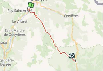
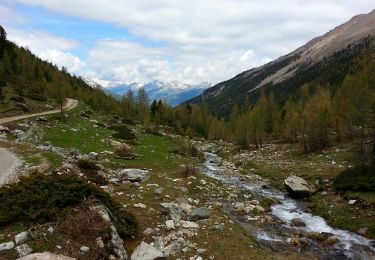
Trail On foot of 17.9 km to be discovered at Provence-Alpes-Côte d'Azur, Hautes-Alpes, Briançon. This trail is proposed by MathieuBourgois.

Description

Retour sur le GR 2.5km et 80D
Chalet des Ayes 7.8km et 560D
Jonctionb avec route 14km et 1300D
Brunissart 18km et 1300D  Camping, bar, resto

Elevation profile

Positioning

Country:
France
Region :
Provence-Alpes-Côte d'Azur
Department/Province :
Hautes-Alpes
Municipality :
Briançon
Location:
Unknown
Start:(UTM)
311625 ; 4972072 (32T) N.

Trails nearby

Trail Walking Briançon - Briançon Schappe-3 têtes - Photo
Walking
GUIDE
Orcal37

Walking

Easy
(2)
Briançon, Provence-Alpes-Côte d'Azur, Hautes-Alpes, France
6.5 km | 11 km-effort
2h 5min
Yes
Trail Mountain bike Val-des-Prés - Montgenèvre et col de la Lauze - Photo
Mountain bike
tracegps

Mountain bike

Very difficult
(1)
Val-des-Prés, Provence-Alpes-Côte d'Azur, Hautes-Alpes, France
38 km | 57 km-effort
3h 30min
Yes
Trail Trail Puy-Saint-André - Clos du Vas - Puy Chalvin - Photo
Trail
GUIDE
toutankhcarton

Trail

Medium
Puy-Saint-André, Provence-Alpes-Côte d'Azur, Hautes-Alpes, France
7.4 km | 13.4 km-effort
1h 30min
Yes
Trail Running Puy-Saint-André - Clos du Vas - St Blaise - Briançon - Villar St Pancrace (Hautes-Alpes) - Photo
Running
GUIDE
toutankhcarton

Running

Medium
Puy-Saint-André, Provence-Alpes-Côte d'Azur, Hautes-Alpes, France
8 km | 10 km-effort
1h 7min
Yes
Trail Walking Puy-Saint-André - cime de la condamine - Photo
Walking
GUIDE
amiral13

Walking

Difficult
Puy-Saint-André, Provence-Alpes-Côte d'Azur, Hautes-Alpes, France
13.7 km | 28 km-effort
5h 59min
Yes
Trail Walking Villar-Saint-Pancrace - Briançonnais Chalets des Ayes - Photo
Walking
GUIDE
Orcal37

Walking

Medium
Villar-Saint-Pancrace, Provence-Alpes-Côte d'Azur, Hautes-Alpes, France
7.1 km | 12 km-effort
2h 15min
Yes
Trail Walking Briançon - Circuit: Fort des 3 Têtes et Fort Dauphin - Photo
Walking
GUIDE
lhomme.ph

Walking

Easy
(2)
Briançon, Provence-Alpes-Côte d'Azur, Hautes-Alpes, France
7.4 km | 11.9 km-effort
2h 40min
Yes
Trail Walking Briançon - Briancon: Fort des Trois tètes - Photo
Walking
GUIDE
lhomme.ph

Walking

Very easy
Briançon, Provence-Alpes-Côte d'Azur, Hautes-Alpes, France
5 km | 8.5 km-effort
2h 8min
Yes
Trail Walking Briançon - Briancon: Le tour du Fort des 3 Têtes   - Photo
Walking
GUIDE
lhomme.ph

Walking

Medium
(1)
Briançon, Provence-Alpes-Côte d'Azur, Hautes-Alpes, France
7.7 km | 12.7 km-effort
1h 50min
Yes


Close
My subscriptions