![](/images/other/stat-length.png)
![Trail On foot Névache - Alpes jour 3: Vallée Etroite à - Photo](https://media.geolcdn.com/t/1900/400/ext.pjpeg?maxdim=2&url=https%3A%2F%2Fstatic1.geolcdn.com%2Fsiteimages%2Fupload%2Ffiles%2F1545311037marcheuse_200dpi.jpg)
Alpes jour 3: Vallée Etroite à
MathieuBourgois
User
![Length](/images/other/stat-length.png)
Length
17.1 km
![Max alt](https://static1.geolcdn.com/siteimages/upload/files/1508320355ic_sort_altitude_max_24dp.png)
Max alt
2187 m
![Uphill gradient](https://static1.geolcdn.com/siteimages/upload/files/1508320355ic_sort_den_pos_24dp.png)
Uphill gradient
1044 m
![Km-Effort](/images/other/stat-length.png)
Km-Effort
30 km
![Min alt](https://static1.geolcdn.com/siteimages/upload/files/1508320355ic_sort_altitude_min_24dp.png)
Min alt
1480 m
![Downhill gradient](https://static1.geolcdn.com/siteimages/upload/files/1508320355ic_sort_den_neg_24dp.png)
Downhill gradient
625 m
![Boucle](https://static1.geolcdn.com/siteimages/upload/files/16400158638029165_repeat_loop_refresh_sync_direction_icon.png)
Boucle
No
Creation date :
2020-10-16 08:11:23.093
Updated on :
2021-06-01 12:13:05.896
![On foot](https://static1.geolcdn.com/sitytour/trail-icons/100.png)
--
Difficulty : Medium
![Scan this QR Code to open this trail in the SityTrail application](https://capi.geolives.com/qq0zvz2zws4bq2lad0pu/sitytour/trails/2578528/qr.png?size=200)
FREE GPS app for hiking
About
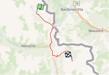
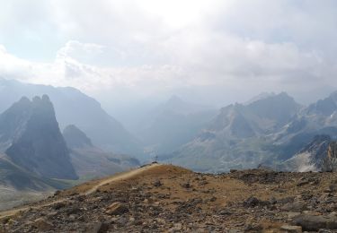
Trail On foot of 17.1 km to be discovered at Provence-Alpes-Côte d'Azur, Hautes-Alpes, Névache. This trail is proposed by MathieuBourgois.
Description
Col des Thures 3.3km et 420D
Roubion 8.4km et 430D
Pamplinet 12km et 460D
Chalet des Acles 16km et 880D
Lieux de Bivouac 18km et 1200D
Positioning
Country:
France
Region :
Provence-Alpes-Côte d'Azur
Department/Province :
Hautes-Alpes
Municipality :
Névache
Location:
Unknown
Start:(Dec)
Start:(UTM)
312855 ; 4993563 (32T) N.
Comments
Trails nearby
![Trail Walking Névache - Lac Vert.Vallée Etroite.(27-09-17) - Photo](https://media.geolcdn.com/t/375/260/ext.jpg?maxdim=2&url=https%3A%2F%2Fservices.sitytrail.com%2FGeolivesWS%2FDownloadMedia.ashx%3FTrailID%3D836355%26Media%3Dfix__20170927160031.jpg)
![Walking Walking](https://static1.geolcdn.com/sitytour/trail-icons/101.png)
Lac Vert.Vallée Etroite.(27-09-17)
Walking
Very easy
(1)
Névache,
Provence-Alpes-Côte d'Azur,
Hautes-Alpes,
France
![](/images/other/stat-length.png)
4.2 km | 5.9 km-effort
1h 19min
![](https://static1.geolcdn.com/siteimages/upload/files/16400158638029165_repeat_loop_refresh_sync_direction_icon.png)
Yes
![Trail Walking Névache - les granges de la vallée étroite au refuge du Mont Thabor - Photo](https://media.geolcdn.com/t/375/260/ext.jpg?maxdim=2&url=https%3A%2F%2Fservices.sitytrail.com%2FGeolivesWS%2FDownloadMedia.ashx%3FTrailID%3D654587%26Media%3Dfix__20161029145821.jpg)
![Walking Walking](https://static1.geolcdn.com/sitytour/trail-icons/101.png)
les granges de la vallée étroite au refuge du Mont Thabor
Walking
Easy
(1)
Névache,
Provence-Alpes-Côte d'Azur,
Hautes-Alpes,
France
![](/images/other/stat-length.png)
8.6 km | 16.2 km-effort
3h 44min
![](https://static1.geolcdn.com/siteimages/upload/files/16400158638029165_repeat_loop_refresh_sync_direction_icon.png)
No
![Trail Mountain bike Névache - Tour des Rois Mages en VTT - Névache - Photo](https://media.geolcdn.com/t/375/260/ext.jpg?maxdim=2&url=https%3A%2F%2Fservices.sitytrail.com%2FGeolivesWS%2FDownloadMedia.ashx%3FTrailID%3D105140%26Media%3D8755_6.jpg)
![Mountain bike Mountain bike](https://static1.geolcdn.com/sitytour/trail-icons/202.png)
Tour des Rois Mages en VTT - Névache
Mountain bike
Difficult
(2)
Névache,
Provence-Alpes-Côte d'Azur,
Hautes-Alpes,
France
![](/images/other/stat-length.png)
35 km | 55 km-effort
5h 0min
![](https://static1.geolcdn.com/siteimages/upload/files/16400158638029165_repeat_loop_refresh_sync_direction_icon.png)
Yes
![Trail Walking Névache - le Mont Thabor - Photo](https://media.geolcdn.com/t/375/260/ext.jpg?maxdim=2&url=https%3A%2F%2Fservices.sitytrail.com%2FGeolivesWS%2FDownloadMedia.ashx%3FTrailID%3D1010217%26Media%3Dfix__20180724163126.jpg)
![Walking Walking](https://static1.geolcdn.com/sitytour/trail-icons/101.png)
le Mont Thabor
Walking
Difficult
Névache,
Provence-Alpes-Côte d'Azur,
Hautes-Alpes,
France
![](/images/other/stat-length.png)
19.9 km | 40 km-effort
8h 44min
![](https://static1.geolcdn.com/siteimages/upload/files/16400158638029165_repeat_loop_refresh_sync_direction_icon.png)
Yes
![Trail Walking Névache - Vallée étroite refuge du Thabor - Photo](https://media.geolcdn.com/t/375/260/caa80d0d-fb96-4075-98b9-465015f706c8.jpg&format=jpg&maxdim=2)
![Walking Walking](https://static1.geolcdn.com/sitytour/trail-icons/101.png)
Vallée étroite refuge du Thabor
Walking
Difficult
Névache,
Provence-Alpes-Côte d'Azur,
Hautes-Alpes,
France
![](/images/other/stat-length.png)
10.2 km | 18.4 km-effort
3h 6min
![](https://static1.geolcdn.com/siteimages/upload/files/16400158638029165_repeat_loop_refresh_sync_direction_icon.png)
No
![Trail sport Névache - Vallée étroite thabor - Photo](https://media.geolcdn.com/t/375/260/97f1c275-6e3e-47a5-b5da-c9a6fca0b09d.jpg&format=jpg&maxdim=2)
Vallée étroite thabor
sport
Very easy
Névache,
Provence-Alpes-Côte d'Azur,
Hautes-Alpes,
France
![](/images/other/stat-length.png)
23 km | 43 km-effort
Unknown
![](https://static1.geolcdn.com/siteimages/upload/files/16400158638029165_repeat_loop_refresh_sync_direction_icon.png)
Yes
![Trail Walking Névache - J4 2023 - Le Thabor épisode 2 - Photo](https://media.geolcdn.com/t/375/260/6eb284de-df6c-41f9-bcd4-8d0010541a10.jpg&format=jpg&maxdim=2)
![Walking Walking](https://static1.geolcdn.com/sitytour/trail-icons/101.png)
J4 2023 - Le Thabor épisode 2
Walking
Very difficult
Névache,
Provence-Alpes-Côte d'Azur,
Hautes-Alpes,
France
![](/images/other/stat-length.png)
24 km | 44 km-effort
7h 13min
![](https://static1.geolcdn.com/siteimages/upload/files/16400158638029165_repeat_loop_refresh_sync_direction_icon.png)
Yes
![Trail Walking Névache - Mont Thabor à partir des Granges - Photo](https://media.geolcdn.com/t/375/260/b11e8d82-1743-4a03-9b5b-b7f5a70282e9.jpg&format=jpg&maxdim=2)
![Walking Walking](https://static1.geolcdn.com/sitytour/trail-icons/101.png)
Mont Thabor à partir des Granges
Walking
Very difficult
Névache,
Provence-Alpes-Côte d'Azur,
Hautes-Alpes,
France
![](/images/other/stat-length.png)
18.1 km | 37 km-effort
6h 39min
![](https://static1.geolcdn.com/siteimages/upload/files/16400158638029165_repeat_loop_refresh_sync_direction_icon.png)
No
![Trail Touring skiing Névache - mont thabor - Photo](https://media.geolcdn.com/t/375/260/1fa36a59-1268-4337-a86b-af6077f119fc.jpg&format=jpg&maxdim=2)
![Touring skiing Touring skiing](https://static1.geolcdn.com/sitytour/trail-icons/503.png)
mont thabor
Touring skiing
Difficult
Névache,
Provence-Alpes-Côte d'Azur,
Hautes-Alpes,
France
![](/images/other/stat-length.png)
799 km | 2069 km-effort
6h 18min
![](https://static1.geolcdn.com/siteimages/upload/files/16400158638029165_repeat_loop_refresh_sync_direction_icon.png)
No