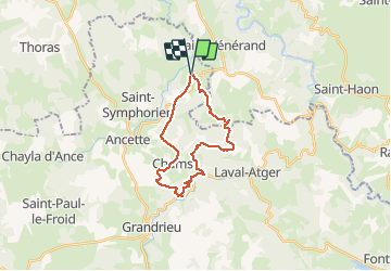
Trail Walking Bel-Air-Val-d'Ance - chanbon le chateau - Photo
 boyer43
boyer43

User

© OpenStreetMap contributors
Length
Length
22 km
Max alt
Max alt
1203 m
Uphill gradient
Uphill gradient
685 m
Km-Effort
Km-Effort  
31 km
Min alt
Min alt
990 m
Downhill gradient
Downhill gradient
686 m
Boucle
Boucle
Yes
Creation date :
2020-10-11 08:34:12.355
Updated on :
2020-10-11 08:35:53.39

(0 Reviews)

Walking
Walking
6h28
Difficulty : Very difficult

Scan this QR Code to open this trail in the SityTrail application

FREE GPS app for hiking

Logo SityTrail SityTrail

IGN / Geographical institutes

Download SityTrail from the App Store Download SityTrail from Google Play

Logo SityTrail SityTrail World

The world is yours!

Download SityTrail from the App Store Download SityTrail from Google Play Download SityTrail on Huawei AppGallery

About

Trail Walking of 22 km to be discovered at Occitania, Lozère, Bel-Air-Val-d'Ance. This trail is proposed by boyer43.

Elevation profile

Positioning

Country:
France
Region :
Occitania
Department/Province :
Lozère
Municipality :
Bel-Air-Val-d'Ance
Location:
Chambon-le-Château
Start:(UTM)
552130 ; 4966840 (31T) N.

Trails nearby

Trail Walking Alleyras - GR 470 Pourcheresse / Chapeauroux - Photo
Walking
GUIDE
nadinebondoux

Walking

Medium
Alleyras, Auvergne-Rhône-Alpes, Haute-Loire, France
17.4 km | 24 km-effort
5h 8min
No
Trail On foot Saint-Christophe-d'Allier - Les bords de l'Allier - Photo
On foot
PRO

On foot

Easy
Saint-Christophe-d'Allier, Auvergne-Rhône-Alpes, Haute-Loire, France
9.8 km | 13.4 km-effort
3h 3min
Yes
Trail Mountain bike Saint-Christophe-d'Allier - Sodo fin rouluraid 2024 - Photo
Mountain bike
Halberstadt

Mountain bike

Easy
Saint-Christophe-d'Allier, Auvergne-Rhône-Alpes, Haute-Loire, France
12.4 km | 16.2 km-effort
2h 4min
Yes
Trail Walking Alleyras - GORGES DE L ALLIER 7 - Photo
Walking
LOICFOUCRIT

Walking

Very difficult
(1)
Alleyras, Auvergne-Rhône-Alpes, Haute-Loire, France
19.9 km | 29 km-effort
6h 32min
No
Trail Horseback riding Grandrieu - 9554824-boucle mazimbert 4 - Photo
Horseback riding
Lozère Cheval

Horseback riding

Difficult
Grandrieu, Occitania, Lozère, France
24 km | 32 km-effort
4h 14min
Yes
Trail Horseback riding Bel-Air-Val-d'Ance - 9555005-boucle besseyrettes mazimbert - Photo
Horseback riding
Lozère Cheval

Horseback riding

Difficult
Bel-Air-Val-d'Ance, Occitania, Lozère, France
24 km | 32 km-effort
4h 16min
Yes
Trail Horseback riding Bel-Air-Val-d'Ance - 9555109-boucle besseyrettes st prejet - Photo
Horseback riding
Lozère Cheval

Horseback riding

Medium
Bel-Air-Val-d'Ance, Occitania, Lozère, France
19.1 km | 28 km-effort
3h 39min
Yes
Trail Horseback riding Bel-Air-Val-d'Ance - 9555209-besseyrettes vazeille - Photo
Horseback riding
Lozère Cheval

Horseback riding

Difficult
Bel-Air-Val-d'Ance, Occitania, Lozère, France
25 km | 35 km-effort
4h 38min
Yes
Trail Horseback riding Bel-Air-Val-d'Ance - 9555155-boucle besseyrette le chateau du fort - Photo
Horseback riding
Lozère Cheval

Horseback riding

Difficult
Bel-Air-Val-d'Ance, Occitania, Lozère, France
23 km | 34 km-effort
4h 25min
Yes


Close
My subscriptions