![](/images/other/stat-length.png)
![Trail Walking Germ - GERM la cabane d Ourtiga G3 fait - Photo](https://media.geolcdn.com/t/1900/400/2e736210-e73c-4bad-ba88-e25ece772a2a.jpg&format=pjpeg&maxdim=2)
GERM la cabane d Ourtiga G3 fait
marmotte65
User GUIDE
![Length](/images/other/stat-length.png)
Length
10.6 km
![Max alt](https://static1.geolcdn.com/siteimages/upload/files/1508320355ic_sort_altitude_max_24dp.png)
Max alt
1619 m
![Uphill gradient](https://static1.geolcdn.com/siteimages/upload/files/1508320355ic_sort_den_pos_24dp.png)
Uphill gradient
432 m
![Km-Effort](/images/other/stat-length.png)
Km-Effort
16.4 km
![Min alt](https://static1.geolcdn.com/siteimages/upload/files/1508320355ic_sort_altitude_min_24dp.png)
Min alt
1275 m
![Downhill gradient](https://static1.geolcdn.com/siteimages/upload/files/1508320355ic_sort_den_neg_24dp.png)
Downhill gradient
441 m
![Boucle](https://static1.geolcdn.com/siteimages/upload/files/16400158638029165_repeat_loop_refresh_sync_direction_icon.png)
Boucle
Yes
Creation date :
2020-10-09 08:01:45.356
Updated on :
2020-10-15 12:49:20.706
![Walking](https://static1.geolcdn.com/sitytour/trail-icons/101.png)
5h33
Difficulty : Medium
![Scan this QR Code to open this trail in the SityTrail application](https://capi.geolives.com/qq0zvz2zws4bq2lad0pu/sitytour/trails/2572747/qr.png?size=200)
FREE GPS app for hiking
About
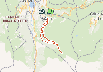
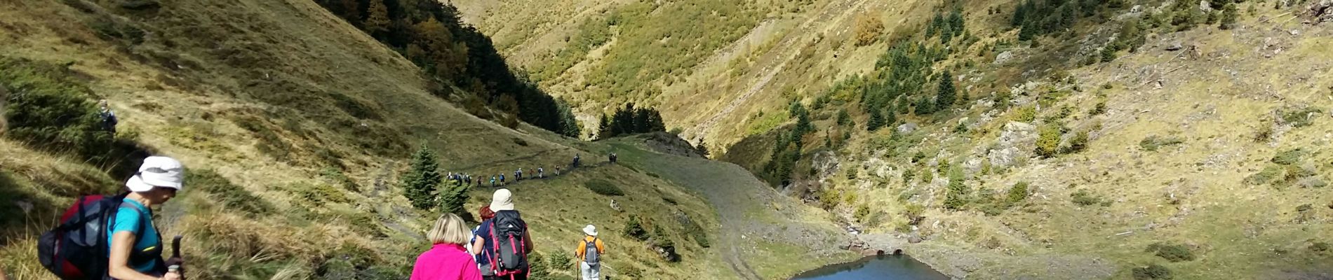
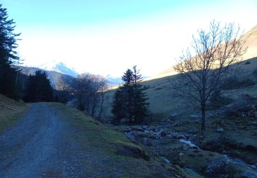
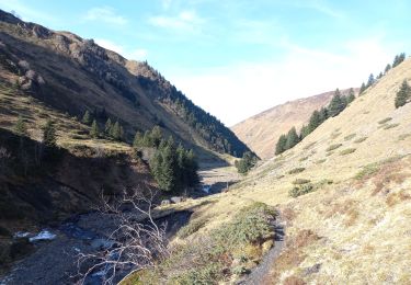
Trail Walking of 10.6 km to be discovered at Occitania, Hautespyrenees, Germ. This trail is proposed by marmotte65.
Description
pas de difficulté majeure éviter la seconde partie du GR10 et prendre la variante au niveau du petit barrage , passer sur la rive G.
Au retour au même endroit possibilité de prendre le sentier en face juste avant de traverser le barrage.
Positioning
Country:
France
Region :
Occitania
Department/Province :
Hautespyrenees
Municipality :
Germ
Location:
Unknown
Start:(Dec)
Start:(UTM)
289469 ; 4741043 (31T) N.
Comments
Trails nearby
![Trail Walking Portet-de-Luchon - Du Col de Peyresourde au sommet du Pouyaué - Loudervielle - Photo](https://media.geolcdn.com/t/375/260/ext.jpg?maxdim=2&url=https%3A%2F%2Fservices.sitytrail.com%2FGeolivesWS%2FDownloadMedia.ashx%3FTrailID%3D173038%26Media%3D14554_6.jpg)
![Walking Walking](https://static1.geolcdn.com/sitytour/trail-icons/101.png)
Du Col de Peyresourde au sommet du Pouyaué - Loudervielle
Walking
Difficult
(1)
Portet-de-Luchon,
Occitania,
Haute-Garonne,
France
![](/images/other/stat-length.png)
9.9 km | 18.4 km-effort
4h 10min
![](https://static1.geolcdn.com/siteimages/upload/files/16400158638029165_repeat_loop_refresh_sync_direction_icon.png)
Yes
![Trail Walking Azet - col azet - Photo](https://media.geolcdn.com/t/375/260/ext.jpg?maxdim=2&url=https%3A%2F%2Fservices.sitytrail.com%2FGeolivesWS%2FDownloadMedia.ashx%3FTrailID%3D149546%26Media%3D20120817125202.jpg)
![Walking Walking](https://static1.geolcdn.com/sitytour/trail-icons/101.png)
col azet
Walking
Easy
(1)
Azet,
Occitania,
Hautespyrenees,
France
![](/images/other/stat-length.png)
6.4 km | 9.2 km-effort
2h 10min
![](https://static1.geolcdn.com/siteimages/upload/files/16400158638029165_repeat_loop_refresh_sync_direction_icon.png)
Yes
![Trail Walking Loudenvielle - Val d'Aube - Photo](https://media.geolcdn.com/t/375/260/ext.jpg?maxdim=2&url=https%3A%2F%2Fservices.sitytrail.com%2FGeolivesWS%2FDownloadMedia.ashx%3FTrailID%3D334907%26Media%3Dfix__20140814144319.jpg)
![Walking Walking](https://static1.geolcdn.com/sitytour/trail-icons/101.png)
Val d'Aube
Walking
Medium
(3)
Loudenvielle,
Occitania,
Hautespyrenees,
France
![](/images/other/stat-length.png)
11.1 km | 19.5 km-effort
4h 19min
![](https://static1.geolcdn.com/siteimages/upload/files/16400158638029165_repeat_loop_refresh_sync_direction_icon.png)
Yes
![Trail Walking Loudenvielle - Cabana d'ourtigas - Photo](https://media.geolcdn.com/t/375/260/ext.jpg?maxdim=2&url=https%3A%2F%2Fstatic1.geolcdn.com%2Fsiteimages%2Fupload%2Ffiles%2F1553511878bg_sport_marche.png)
![Walking Walking](https://static1.geolcdn.com/sitytour/trail-icons/101.png)
Cabana d'ourtigas
Walking
Very easy
(1)
Loudenvielle,
Occitania,
Hautespyrenees,
France
![](/images/other/stat-length.png)
14.2 km | 24 km-effort
6h 59min
![](https://static1.geolcdn.com/siteimages/upload/files/16400158638029165_repeat_loop_refresh_sync_direction_icon.png)
Yes
![Trail Snowshoes Germ - Germ raquettes le 27 Janvier 2018-fait - Photo](https://media.geolcdn.com/t/375/260/ext.jpg?maxdim=2&url=https%3A%2F%2Fservices.sitytrail.com%2FGeolivesWS%2FDownloadMedia.ashx%3FTrailID%3D895724%26Media%3Dfix__20180128125818.jpg)
![Snowshoes Snowshoes](https://static1.geolcdn.com/sitytour/trail-icons/504.png)
Germ raquettes le 27 Janvier 2018-fait
Snowshoes
Medium
Germ,
Occitania,
Hautespyrenees,
France
![](/images/other/stat-length.png)
5.3 km | 9.1 km-effort
5h 7min
![](https://static1.geolcdn.com/siteimages/upload/files/16400158638029165_repeat_loop_refresh_sync_direction_icon.png)
Yes
![Trail Walking Azet - Au col d'Azet - Photo](https://media.geolcdn.com/t/375/260/ext.jpg?maxdim=2&url=https%3A%2F%2Fstatic1.geolcdn.com%2Fsiteimages%2Fupload%2Ffiles%2F1553511878bg_sport_marche.png)
![Walking Walking](https://static1.geolcdn.com/sitytour/trail-icons/101.png)
Au col d'Azet
Walking
Medium
(1)
Azet,
Occitania,
Hautespyrenees,
France
![](/images/other/stat-length.png)
7.3 km | 10.5 km-effort
2h 19min
![](https://static1.geolcdn.com/siteimages/upload/files/16400158638029165_repeat_loop_refresh_sync_direction_icon.png)
Yes
![Trail Walking Azet - J4 Néouvelle 2024 : Col d’Azet - Photo](https://media.geolcdn.com/t/375/260/9d44ad7c-f24c-41b8-a1e4-5c7ed0850111.jpg&format=jpg&maxdim=2)
![Walking Walking](https://static1.geolcdn.com/sitytour/trail-icons/101.png)
J4 Néouvelle 2024 : Col d’Azet
Walking
Medium
Azet,
Occitania,
Hautespyrenees,
France
![](/images/other/stat-length.png)
13.7 km | 21 km-effort
4h 40min
![](https://static1.geolcdn.com/siteimages/upload/files/16400158638029165_repeat_loop_refresh_sync_direction_icon.png)
Yes
![Trail Walking Cazaux-Fréchet-Anéran-Camors - Boucle de Mont - Photo](https://media.geolcdn.com/t/375/260/3df0af8c-56ad-4cc6-95ed-91ab49d2a00c.jpg&format=jpg&maxdim=2)
![Walking Walking](https://static1.geolcdn.com/sitytour/trail-icons/101.png)
Boucle de Mont
Walking
Medium
Cazaux-Fréchet-Anéran-Camors,
Occitania,
Hautespyrenees,
France
![](/images/other/stat-length.png)
13.1 km | 22 km-effort
3h 4min
![](https://static1.geolcdn.com/siteimages/upload/files/16400158638029165_repeat_loop_refresh_sync_direction_icon.png)
Yes
![Trail Walking Loudenvielle - La cabane d'Ourcibat - Photo](https://media.geolcdn.com/t/375/260/c5c26dd7-cde0-48bc-8dc9-164e15155370.jpg&format=jpg&maxdim=2)
![Walking Walking](https://static1.geolcdn.com/sitytour/trail-icons/101.png)
La cabane d'Ourcibat
Walking
Medium
Loudenvielle,
Occitania,
Hautespyrenees,
France
![](/images/other/stat-length.png)
14.6 km | 24 km-effort
4h 28min
![](https://static1.geolcdn.com/siteimages/upload/files/16400158638029165_repeat_loop_refresh_sync_direction_icon.png)
Yes