![](/images/other/stat-length.png)
![Trail Walking Camps-sur-l'Agly - Pech de Bugarach (départ de la Bastide - Camps-sur-l'Agly) - Photo](https://media.geolcdn.com/t/1900/400/8fe478a1-aac1-4e62-9fee-db7a2d6e2489.jpg&format=pjpeg&maxdim=2)
Pech de Bugarach (départ de la Bastide - Camps-sur-l'Agly)
PiloudeBamako
User
![Length](/images/other/stat-length.png)
![Max alt](https://static1.geolcdn.com/siteimages/upload/files/1508320355ic_sort_altitude_max_24dp.png)
![Uphill gradient](https://static1.geolcdn.com/siteimages/upload/files/1508320355ic_sort_den_pos_24dp.png)
![Km-Effort](/images/other/stat-length.png)
![Min alt](https://static1.geolcdn.com/siteimages/upload/files/1508320355ic_sort_altitude_min_24dp.png)
![Downhill gradient](https://static1.geolcdn.com/siteimages/upload/files/1508320355ic_sort_den_neg_24dp.png)
![Boucle](https://static1.geolcdn.com/siteimages/upload/files/16400158638029165_repeat_loop_refresh_sync_direction_icon.png)
![Walking](https://static1.geolcdn.com/sitytour/trail-icons/101.png)
6h17
Difficulty : Difficult
![Scan this QR Code to open this trail in the SityTrail application](https://capi.geolives.com/qq0zvz2zws4bq2lad0pu/sitytour/trails/2572015/qr.png?size=200)
FREE GPS app for hiking
About
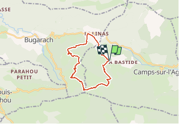
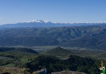
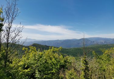
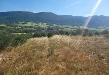
Trail Walking of 12.7 km to be discovered at Occitania, Aude, Camps-sur-l'Agly. This trail is proposed by PiloudeBamako.
Description
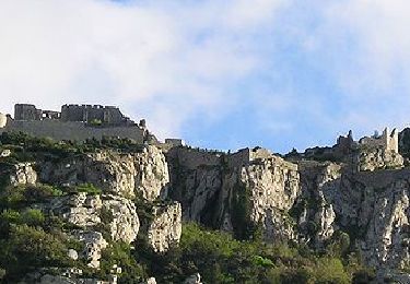
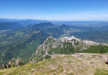
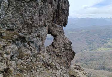
Contournement du Pech par le Sud (GR 367) au départ du hameau de la Bastide (commune de Camps-sur-l'Agly). Ascension par le GR 36 et "la fenêtre".
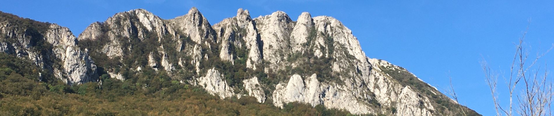
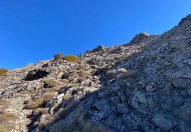
Descente (pente forte et glissante par temps humide) par le Nord du Pech vers le col de Linas.
A mon avis, l'ascension doit se faire dans ce sens car la descente du Pech par "la fenêtre" est très escarpée et impressionnante face au vide, alors que la montée est assez facile dos au vide.
Positioning
Comments
Trails nearby
![Trail Walking Bugarach - Le Pech de Bugarach - Photo](https://media.geolcdn.com/t/375/260/ext.jpg?maxdim=2&url=https%3A%2F%2Fservices.sitytrail.com%2FGeolivesWS%2FDownloadMedia.ashx%3FTrailID%3D103373%26Media%3D5434_4.jpg)
![Walking Walking](https://static1.geolcdn.com/sitytour/trail-icons/101.png)
Walking
![](/images/other/stat-length.png)
![](https://static1.geolcdn.com/siteimages/upload/files/16400158638029165_repeat_loop_refresh_sync_direction_icon.png)
![Trail Walking Bugarach - Le Pech de Bugarach 1230 m, depuis le Col du Linas - Photo](https://media.geolcdn.com/t/375/260/ext.jpg?maxdim=2&url=https%3A%2F%2Fservices.sitytrail.com%2FGeolivesWS%2FDownloadMedia.ashx%3FTrailID%3D191665%26Media%3D15324_1.jpg)
![Walking Walking](https://static1.geolcdn.com/sitytour/trail-icons/101.png)
Walking
![](/images/other/stat-length.png)
![](https://static1.geolcdn.com/siteimages/upload/files/16400158638029165_repeat_loop_refresh_sync_direction_icon.png)
![Trail Walking Bugarach - Bugarach par la fenêtre - Photo](https://media.geolcdn.com/t/375/260/f61c8120-4edd-4c37-b8d1-8f8539bc9df7.jpg&format=jpg&maxdim=2)
![Walking Walking](https://static1.geolcdn.com/sitytour/trail-icons/101.png)
Walking
![](/images/other/stat-length.png)
![](https://static1.geolcdn.com/siteimages/upload/files/16400158638029165_repeat_loop_refresh_sync_direction_icon.png)
![Trail Walking Bugarach - pic du Bugarach - Photo](https://media.geolcdn.com/t/375/260/0be0b540-d788-4840-b942-68a2805d5a8a.jpg&format=jpg&maxdim=2)
![Walking Walking](https://static1.geolcdn.com/sitytour/trail-icons/101.png)
Walking
![](/images/other/stat-length.png)
![](https://static1.geolcdn.com/siteimages/upload/files/16400158638029165_repeat_loop_refresh_sync_direction_icon.png)
![Trail Walking Bugarach - le Pech de Bugarach - Lac de La vène - Photo](https://media.geolcdn.com/t/375/260/d1455a7d-4be7-4620-998d-a60e0cfc8767.jpg&format=jpg&maxdim=2)
![Walking Walking](https://static1.geolcdn.com/sitytour/trail-icons/101.png)
Walking
![](/images/other/stat-length.png)
![](https://static1.geolcdn.com/siteimages/upload/files/16400158638029165_repeat_loop_refresh_sync_direction_icon.png)
![Trail Walking Sougraigne - Sougraigne bugarach pont romain - Photo](https://media.geolcdn.com/t/375/260/ad5479a5-b384-460d-9d60-d556ca1f7a71.jpg&format=jpg&maxdim=2)
![Walking Walking](https://static1.geolcdn.com/sitytour/trail-icons/101.png)
Walking
![](/images/other/stat-length.png)
![](https://static1.geolcdn.com/siteimages/upload/files/16400158638029165_repeat_loop_refresh_sync_direction_icon.png)
![Trail Walking Prugnanes - roc paradet - Photo](https://media.geolcdn.com/t/375/260/f4e6fd12-f0ab-4601-9b76-44d15e72f3de.jpg&format=jpg&maxdim=2)
![Walking Walking](https://static1.geolcdn.com/sitytour/trail-icons/101.png)
Walking
![](/images/other/stat-length.png)
![](https://static1.geolcdn.com/siteimages/upload/files/16400158638029165_repeat_loop_refresh_sync_direction_icon.png)
![Trail Walking Bugarach - Tour Bugarach - Photo](https://media.geolcdn.com/t/375/260/8fec2c3e-ab59-425a-8e19-942b2c7606b2.jpg&format=jpg&maxdim=2)
![Walking Walking](https://static1.geolcdn.com/sitytour/trail-icons/101.png)
![Trail Walking Bugarach - Col du Linas-Pech de Bugarach-La fenêtre - Photo](https://media.geolcdn.com/t/375/260/45453090-280d-427b-b6e8-17db17de82e5.jpg&format=jpg&maxdim=2)
![Walking Walking](https://static1.geolcdn.com/sitytour/trail-icons/101.png)
Walking
![](/images/other/stat-length.png)
![](https://static1.geolcdn.com/siteimages/upload/files/16400158638029165_repeat_loop_refresh_sync_direction_icon.png)