![](/images/other/stat-length.png)
![Trail On foot Sivry-Rance - Rance -Domaniale - Photo](https://media.geolcdn.com/t/1900/400/ext.pjpeg?maxdim=2&url=https%3A%2F%2Fstatic1.geolcdn.com%2Fsiteimages%2Fupload%2Ffiles%2F1545311037marcheuse_200dpi.jpg)
Rance -Domaniale
chanthan
User
![Length](/images/other/stat-length.png)
Length
6.3 km
![Max alt](https://static1.geolcdn.com/siteimages/upload/files/1508320355ic_sort_altitude_max_24dp.png)
Max alt
273 m
![Uphill gradient](https://static1.geolcdn.com/siteimages/upload/files/1508320355ic_sort_den_pos_24dp.png)
Uphill gradient
78 m
![Km-Effort](/images/other/stat-length.png)
Km-Effort
7.3 km
![Min alt](https://static1.geolcdn.com/siteimages/upload/files/1508320355ic_sort_altitude_min_24dp.png)
Min alt
209 m
![Downhill gradient](https://static1.geolcdn.com/siteimages/upload/files/1508320355ic_sort_den_neg_24dp.png)
Downhill gradient
79 m
![Boucle](https://static1.geolcdn.com/siteimages/upload/files/16400158638029165_repeat_loop_refresh_sync_direction_icon.png)
Boucle
Yes
Creation date :
2020-10-08 11:48:50.559
Updated on :
2020-10-08 16:41:20.263
![On foot](https://static1.geolcdn.com/sitytour/trail-icons/100.png)
--
Difficulty : Easy
![Scan this QR Code to open this trail in the SityTrail application](https://capi.geolives.com/qq0zvz2zws4bq2lad0pu/sitytour/trails/2571660/qr.png?size=200)
FREE GPS app for hiking
About
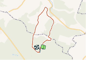
Trail On foot of 6.3 km to be discovered at Wallonia, Hainaut, Sivry-Rance. This trail is proposed by chanthan.
Description
Départ d'un parking dans le chemin de 15 pieds de la domaniale de Rance.
Coordonnées : E 4.2640 N 50.1599. Parcours à travers les bois jusqu'à Cuquegnies, hameau de Renlies, retour par le bois de la domaniale. Facile.
Positioning
Country:
Belgium
Region :
Wallonia
Department/Province :
Hainaut
Municipality :
Sivry-Rance
Location:
Rance
Start:(Dec)
Start:(UTM)
590264 ; 5557177 (31U) N.
Comments
Trails nearby
![Trail Hybrid bike Sivry-Rance - Sivry Gare - Robechies - Rance - Photo](https://media.geolcdn.com/t/375/260/73d602ef-978e-4b6d-980e-4af8ec05b02c.jpg&format=jpg&maxdim=2)
![Hybrid bike Hybrid bike](https://static1.geolcdn.com/sitytour/trail-icons/203.png)
Sivry Gare - Robechies - Rance
Hybrid bike
Very easy
(2)
Sivry-Rance,
Wallonia,
Hainaut,
Belgium
![](/images/other/stat-length.png)
41 km | 48 km-effort
2h 31min
![](https://static1.geolcdn.com/siteimages/upload/files/16400158638029165_repeat_loop_refresh_sync_direction_icon.png)
Yes
![Trail Mountain bike Froidchapelle - Froidchapelle (7) - Mountain Bike Walk - Photo](https://media.geolcdn.com/t/375/260/ext.jpg?maxdim=2&url=https%3A%2F%2Fservices.sitytrail.com%2FGeolivesWS%2FDownloadMedia.ashx%3FTrailID%3D332241%26Media%3D0e28cef3-8d87-404e-aa4c-8e4248f5e1b1.JPG)
![Mountain bike Mountain bike](https://static1.geolcdn.com/sitytour/trail-icons/202.png)
Froidchapelle (7) - Mountain Bike Walk
Mountain bike
Medium
(4)
Froidchapelle,
Wallonia,
Hainaut,
Belgium
![](/images/other/stat-length.png)
32 km | 37 km-effort
2h 26min
![](https://static1.geolcdn.com/siteimages/upload/files/16400158638029165_repeat_loop_refresh_sync_direction_icon.png)
Yes
![Trail Walking Sivry-Rance - Sivry-Rance (06) - Sivry - Grand Thumas Walk - Photo](https://media.geolcdn.com/t/375/260/ext.jpg?maxdim=2&url=https%3A%2F%2Fservices.sitytrail.com%2FGeolivesWS%2FDownloadMedia.ashx%3FTrailID%3D311164%26Media%3D8cc43fbe-f875-4530-a462-14a28c742760.JPG)
![Walking Walking](https://static1.geolcdn.com/sitytour/trail-icons/101.png)
Sivry-Rance (06) - Sivry - Grand Thumas Walk
Walking
Very easy
(5)
Sivry-Rance,
Wallonia,
Hainaut,
Belgium
![](/images/other/stat-length.png)
5.5 km | 6.5 km-effort
1h 30min
![](https://static1.geolcdn.com/siteimages/upload/files/16400158638029165_repeat_loop_refresh_sync_direction_icon.png)
Yes
![Trail Walking Sivry-Rance - RB-HA-10 - Boucle champêtre autour de la Sambre - Photo](https://media.geolcdn.com/t/375/260/ext.jpg?maxdim=2&url=https%3A%2F%2Fservices.sitytrail.com%2FGeolivesWS%2FDownloadMedia.ashx%3FTrailID%3D219204%26Media%3De74974e9-21e7-4886-b770-97222bcdf8f4.jpg)
![Walking Walking](https://static1.geolcdn.com/sitytour/trail-icons/101.png)
RB-HA-10 - Boucle champêtre autour de la Sambre
Walking
Very difficult
(1)
Sivry-Rance,
Wallonia,
Hainaut,
Belgium
![](/images/other/stat-length.png)
21 km | 25 km-effort
5h 47min
![](https://static1.geolcdn.com/siteimages/upload/files/16400158638029165_repeat_loop_refresh_sync_direction_icon.png)
Yes
![Trail Walking Sivry-Rance - Sivry-Rance (13) - Vallée de l'Eau d'Eppe (Eppe Water Valley) Walk - Photo](https://media.geolcdn.com/t/375/260/ext.jpg?maxdim=2&url=https%3A%2F%2Fservices.sitytrail.com%2FGeolivesWS%2FDownloadMedia.ashx%3FTrailID%3D311163%26Media%3Db7af1830-b06f-43cc-9ab9-a464f12aaa86.JPG)
![Walking Walking](https://static1.geolcdn.com/sitytour/trail-icons/101.png)
Sivry-Rance (13) - Vallée de l'Eau d'Eppe (Eppe Water Valley) Walk
Walking
Very easy
(2)
Sivry-Rance,
Wallonia,
Hainaut,
Belgium
![](/images/other/stat-length.png)
6.6 km | 8.4 km-effort
2h 0min
![](https://static1.geolcdn.com/siteimages/upload/files/16400158638029165_repeat_loop_refresh_sync_direction_icon.png)
Yes
![Trail Walking Sivry-Rance - De Sautin vers Montbliart par la vallee de l'Eau d'Eppe - Photo](https://media.geolcdn.com/t/375/260/ext.jpg?maxdim=2&url=https%3A%2F%2Fstatic1.geolcdn.com%2Fsiteimages%2Fupload%2Ffiles%2F1553511878bg_sport_marche.png)
![Walking Walking](https://static1.geolcdn.com/sitytour/trail-icons/101.png)
De Sautin vers Montbliart par la vallee de l'Eau d'Eppe
Walking
Medium
(1)
Sivry-Rance,
Wallonia,
Hainaut,
Belgium
![](/images/other/stat-length.png)
17.3 km | 21 km-effort
4h 20min
![](https://static1.geolcdn.com/siteimages/upload/files/16400158638029165_repeat_loop_refresh_sync_direction_icon.png)
Yes
![Trail On foot Sivry-Rance - Promenade du Ry d'Hernoy - Photo](https://media.geolcdn.com/t/375/260/3576f0ab-5152-4ef1-90e0-3b37b935b6bd.jpeg&format=jpg&maxdim=2)
![On foot On foot](https://static1.geolcdn.com/sitytour/trail-icons/100.png)
Promenade du Ry d'Hernoy
On foot
Easy
Sivry-Rance,
Wallonia,
Hainaut,
Belgium
![](/images/other/stat-length.png)
9.8 km | 11.8 km-effort
2h 41min
![](https://static1.geolcdn.com/siteimages/upload/files/16400158638029165_repeat_loop_refresh_sync_direction_icon.png)
Yes
![Trail On foot Sivry-Rance - Promenade circulaire de l'Ermitage - Photo](https://media.geolcdn.com/t/375/260/ext.jpg?maxdim=2&url=https%3A%2F%2Fpivotmedia.tourismewallonie.be%2FOTH-A0-004E-1IGH%2FOTH-A0-004E-1IGH.jpg)
![On foot On foot](https://static1.geolcdn.com/sitytour/trail-icons/100.png)
Promenade circulaire de l'Ermitage
On foot
Easy
Sivry-Rance,
Wallonia,
Hainaut,
Belgium
![](/images/other/stat-length.png)
4.7 km | 5.5 km-effort
1h 15min
![](https://static1.geolcdn.com/siteimages/upload/files/16400158638029165_repeat_loop_refresh_sync_direction_icon.png)
Yes
![Trail Mountain bike Froidchapelle - Promenade VTT - Froidchapelle - Photo](https://media.geolcdn.com/t/375/260/ext.jpg?maxdim=2&url=https%3A%2F%2Fpivotmedia.tourismewallonie.be%2FOTH-A0-004C-1TOP%2FOTH-A0-004C-1TOP.jpg)
![Mountain bike Mountain bike](https://static1.geolcdn.com/sitytour/trail-icons/202.png)
Promenade VTT - Froidchapelle
Mountain bike
Difficult
Froidchapelle,
Wallonia,
Hainaut,
Belgium
![](/images/other/stat-length.png)
32 km | 37 km-effort
2h 35min
![](https://static1.geolcdn.com/siteimages/upload/files/16400158638029165_repeat_loop_refresh_sync_direction_icon.png)
Yes