![](/images/other/stat-length.png)
![Trail Walking Villaz - Découverte de Villaz - Photo](https://media.geolcdn.com/t/1900/400/ext.pjpeg?maxdim=2&url=https%3A%2F%2Fstatic1.geolcdn.com%2Fsiteimages%2Fupload%2Ffiles%2F1553511878bg_sport_marche.png)
Découverte de Villaz
COMAN
User
![Length](/images/other/stat-length.png)
Length
5.7 km
![Max alt](https://static1.geolcdn.com/siteimages/upload/files/1508320355ic_sort_altitude_max_24dp.png)
Max alt
698 m
![Uphill gradient](https://static1.geolcdn.com/siteimages/upload/files/1508320355ic_sort_den_pos_24dp.png)
Uphill gradient
108 m
![Km-Effort](/images/other/stat-length.png)
Km-Effort
7.1 km
![Min alt](https://static1.geolcdn.com/siteimages/upload/files/1508320355ic_sort_altitude_min_24dp.png)
Min alt
599 m
![Downhill gradient](https://static1.geolcdn.com/siteimages/upload/files/1508320355ic_sort_den_neg_24dp.png)
Downhill gradient
108 m
![Boucle](https://static1.geolcdn.com/siteimages/upload/files/16400158638029165_repeat_loop_refresh_sync_direction_icon.png)
Boucle
Yes
Creation date :
2020-10-08 11:30:35.696
Updated on :
2020-10-08 11:41:23.981
![Walking](https://static1.geolcdn.com/sitytour/trail-icons/101.png)
1h48
Difficulty : Medium
![Scan this QR Code to open this trail in the SityTrail application](https://capi.geolives.com/qq0zvz2zws4bq2lad0pu/sitytour/trails/2571485/qr.png?size=200)
FREE GPS app for hiking
About
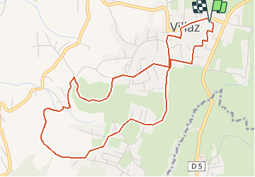
Trail Walking of 5.7 km to be discovered at Auvergne-Rhône-Alpes, Upper Savoy, Villaz. This trail is proposed by COMAN.
Description
Depuis la salle polyvalente jusqu'aux vignes
Beaucoup de route
Découverte des nouveaux aménagements au tour du terrain de sport et des vignes
Positioning
Country:
France
Region :
Auvergne-Rhône-Alpes
Department/Province :
Upper Savoy
Municipality :
Villaz
Location:
Unknown
Start:(Dec)
Start:(UTM)
282580 ; 5092494 (32T) N.
Comments
Trails nearby
![Trail Walking Fillière - LE PARMELAN: ANGLETTAZ - GRANDE GLACIERE - GROTTE DE L'ENFER - LAPIAZ - REFUGE... RETOUR PAR GRAND & PETIT MONTOIR - Photo](https://media.geolcdn.com/t/375/260/ext.jpg?maxdim=2&url=https%3A%2F%2Fmedia.geolcdn.com%2Ff%2F722005e2-5797-472c-b09d-da3e50a0e57d.jpg)
![Walking Walking](https://static1.geolcdn.com/sitytour/trail-icons/101.png)
LE PARMELAN: ANGLETTAZ - GRANDE GLACIERE - GROTTE DE L'ENFER - LAPIAZ - REFUG...
Walking
Difficult
(2)
Fillière,
Auvergne-Rhône-Alpes,
Upper Savoy,
France
![](/images/other/stat-length.png)
9 km | 15.6 km-effort
4h 30min
![](https://static1.geolcdn.com/siteimages/upload/files/16400158638029165_repeat_loop_refresh_sync_direction_icon.png)
Yes
![Trail Walking Fillière - tour parmelan - Photo](https://media.geolcdn.com/t/375/260/ext.jpg?maxdim=2&url=https%3A%2F%2Fstatic1.geolcdn.com%2Fsiteimages%2Fupload%2Ffiles%2F1553511878bg_sport_marche.png)
![Walking Walking](https://static1.geolcdn.com/sitytour/trail-icons/101.png)
tour parmelan
Walking
Easy
(2)
Fillière,
Auvergne-Rhône-Alpes,
Upper Savoy,
France
![](/images/other/stat-length.png)
12.9 km | 22 km-effort
4h 0min
![](https://static1.geolcdn.com/siteimages/upload/files/16400158638029165_repeat_loop_refresh_sync_direction_icon.png)
Yes
![Trail Walking Fillière - chalet de l'angletaz pour Umi - Photo](https://media.geolcdn.com/t/375/260/ext.jpg?maxdim=2&url=https%3A%2F%2Fmedia.geolcdn.com%2Ff%2F31a59abd-fd5f-44b3-890d-ba2d03dc72c1.jpg)
![Walking Walking](https://static1.geolcdn.com/sitytour/trail-icons/101.png)
chalet de l'angletaz pour Umi
Walking
Easy
Fillière,
Auvergne-Rhône-Alpes,
Upper Savoy,
France
![](/images/other/stat-length.png)
3.8 km | 5.7 km-effort
1h 11min
![](https://static1.geolcdn.com/siteimages/upload/files/16400158638029165_repeat_loop_refresh_sync_direction_icon.png)
Yes
![Trail Walking Fillière - refuge Patmelan via anglettaz . gd glacière . fontaine du tour . grotte de l enfer / retour via gd montoir et pt montoir - Photo](https://media.geolcdn.com/t/375/260/ext.jpg?maxdim=2&url=https%3A%2F%2Fmedia.geolcdn.com%2Ff%2Fd9aff979-a700-421f-a6a0-6747275eea2c.jpg)
![Walking Walking](https://static1.geolcdn.com/sitytour/trail-icons/101.png)
refuge Patmelan via anglettaz . gd glacière . fontaine du tour . grotte de l ...
Walking
Medium
Fillière,
Auvergne-Rhône-Alpes,
Upper Savoy,
France
![](/images/other/stat-length.png)
10.2 km | 16.1 km-effort
6h 1min
![](https://static1.geolcdn.com/siteimages/upload/files/16400158638029165_repeat_loop_refresh_sync_direction_icon.png)
Yes
![Trail Walking Fillière - LE PARMELAN: ANGLETTAZ - GRANDE GLACIERE -](https://media.geolcdn.com/t/375/260/ext.jpg?maxdim=2&url=https%3A%2F%2Fmedia.geolcdn.com%2Ff%2F1a67916c-32da-4c49-ba0d-07b010a4e013.jpg)
![Walking Walking](https://static1.geolcdn.com/sitytour/trail-icons/101.png)
LE PARMELAN: ANGLETTAZ - GRANDE GLACIERE - "LES LAPIAZ" - REFUGE DU PARMELAN ...
Walking
Medium
Fillière,
Auvergne-Rhône-Alpes,
Upper Savoy,
France
![](/images/other/stat-length.png)
9.4 km | 14.5 km-effort
4h 35min
![](https://static1.geolcdn.com/siteimages/upload/files/16400158638029165_repeat_loop_refresh_sync_direction_icon.png)
Yes
![Trail Walking Annecy - course avec tobias - Photo](https://media.geolcdn.com/t/375/260/ext.jpg?maxdim=2&url=https%3A%2F%2Fmedia.geolcdn.com%2Ff%2F5511a080-8bbf-4e35-a1e7-eb6c019b0144.jpg)
![Walking Walking](https://static1.geolcdn.com/sitytour/trail-icons/101.png)
course avec tobias
Walking
Medium
Annecy,
Auvergne-Rhône-Alpes,
Upper Savoy,
France
![](/images/other/stat-length.png)
9.9 km | 13.7 km-effort
1h 40min
![](https://static1.geolcdn.com/siteimages/upload/files/16400158638029165_repeat_loop_refresh_sync_direction_icon.png)
Yes
![Trail On foot Dingy-Saint-Clair - PR Boucle du Parmelan - Photo](https://media.geolcdn.com/t/375/260/ext.jpg?maxdim=2&url=https%3A%2F%2Fmedia.geolcdn.com%2Ff%2F6f92a529-84d8-4dac-bcdf-47427f9f0956.jpeg)
![On foot On foot](https://static1.geolcdn.com/sitytour/trail-icons/100.png)
PR Boucle du Parmelan
On foot
Medium
Dingy-Saint-Clair,
Auvergne-Rhône-Alpes,
Upper Savoy,
France
![](/images/other/stat-length.png)
11.3 km | 25 km-effort
5h 38min
![](https://static1.geolcdn.com/siteimages/upload/files/16400158638029165_repeat_loop_refresh_sync_direction_icon.png)
No
![Trail Walking Fillière - Tete du Parmelan - Photo](https://media.geolcdn.com/t/375/260/ext.jpg?maxdim=2&url=https%3A%2F%2Fmedia.geolcdn.com%2Ff%2Fe502a722-32d6-4592-b868-3c83d0cfe463.jpg)
![Walking Walking](https://static1.geolcdn.com/sitytour/trail-icons/101.png)
Tete du Parmelan
Walking
Difficult
Fillière,
Auvergne-Rhône-Alpes,
Upper Savoy,
France
![](/images/other/stat-length.png)
14.9 km | 26 km-effort
7h 15min
![](https://static1.geolcdn.com/siteimages/upload/files/16400158638029165_repeat_loop_refresh_sync_direction_icon.png)
Yes
![Trail Other activity Annecy - Petit guide - Photo](https://media.geolcdn.com/t/375/260/ext.jpg?maxdim=2&url=https%3A%2F%2Fstatic1.geolcdn.com%2Fsiteimages%2Fupload%2Ffiles%2F1545311037marcheuse_200dpi.jpg)
![Other activity Other activity](https://static1.geolcdn.com/sitytour/trail-icons/900.png)
Petit guide
Other activity
Very easy
(1)
Annecy,
Auvergne-Rhône-Alpes,
Upper Savoy,
France
![](/images/other/stat-length.png)
9.1 km | 14 km-effort
1h 40min
![](https://static1.geolcdn.com/siteimages/upload/files/16400158638029165_repeat_loop_refresh_sync_direction_icon.png)
Yes