![](/images/other/stat-length.png)
![Trail On foot Le Morne-Rouge - Le Morne -Rouge - Le Carbet - Photo](https://media.geolcdn.com/t/1900/400/ext.pjpeg?maxdim=2&url=https%3A%2F%2Fstatic1.geolcdn.com%2Fsiteimages%2Fupload%2Ffiles%2F1545311037marcheuse_200dpi.jpg)
Le Morne -Rouge - Le Carbet
Lamartiniere
User GUIDE
![Length](/images/other/stat-length.png)
Length
10 km
![Max alt](https://static1.geolcdn.com/siteimages/upload/files/1508320355ic_sort_altitude_max_24dp.png)
Max alt
514 m
![Uphill gradient](https://static1.geolcdn.com/siteimages/upload/files/1508320355ic_sort_den_pos_24dp.png)
Uphill gradient
310 m
![Km-Effort](/images/other/stat-length.png)
Km-Effort
15.3 km
![Min alt](https://static1.geolcdn.com/siteimages/upload/files/1508320355ic_sort_altitude_min_24dp.png)
Min alt
12 m
![Downhill gradient](https://static1.geolcdn.com/siteimages/upload/files/1508320355ic_sort_den_neg_24dp.png)
Downhill gradient
656 m
![Boucle](https://static1.geolcdn.com/siteimages/upload/files/16400158638029165_repeat_loop_refresh_sync_direction_icon.png)
Boucle
No
Creation date :
2020-10-06 22:27:03.453
Updated on :
2020-10-06 22:33:47.494
![On foot](https://static1.geolcdn.com/sitytour/trail-icons/100.png)
--
Difficulty : Medium
![Scan this QR Code to open this trail in the SityTrail application](https://capi.geolives.com/qq0zvz2zws4bq2lad0pu/sitytour/trails/2570337/qr.png?size=200)
FREE GPS app for hiking
About
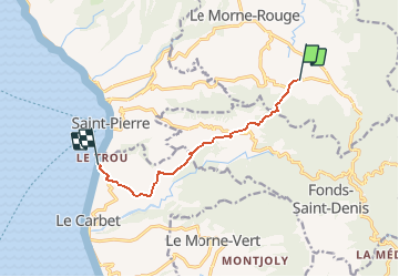
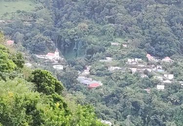
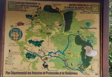
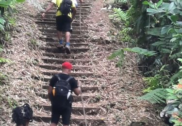
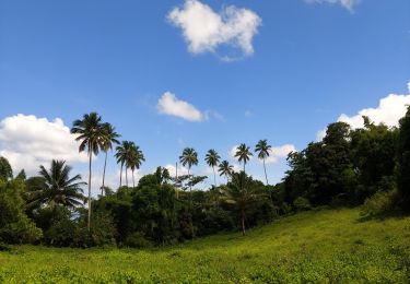
Trail On foot of 10 km to be discovered at Martinique, Unknown, Le Morne-Rouge. This trail is proposed by Lamartiniere.
Description
Randonnée d'environ 10 kms. Départ près la Source minérale Champflore direction le musée Gaugin à Anse Turin au Carbet via le Col Yang Ting avec passage près le morne Gaubert.
Positioning
Country:
France
Region :
Martinique
Department/Province :
Unknown
Municipality :
Le Morne-Rouge
Location:
Unknown
Start:(Dec)
Start:(UTM)
702618 ; 1632007 (20P) N.
Comments
Trails nearby
![Trail Walking Le Morne-Rouge - Sainte Cécile/crête du Cournan/Beauvallon - Photo](https://media.geolcdn.com/t/375/260/0cdc997b-416c-4503-a132-9262284ca457.jpg&format=jpg&maxdim=2)
![Walking Walking](https://static1.geolcdn.com/sitytour/trail-icons/101.png)
Sainte Cécile/crête du Cournan/Beauvallon
Walking
Medium
(1)
Le Morne-Rouge,
Martinique,
Unknown,
France
![](/images/other/stat-length.png)
7.2 km | 11 km-effort
2h 29min
![](https://static1.geolcdn.com/siteimages/upload/files/16400158638029165_repeat_loop_refresh_sync_direction_icon.png)
Yes
![Trail Walking Le Morne-Rouge - Mac Intoch - Morne Capot - Photo](https://media.geolcdn.com/t/375/260/ext.jpg?maxdim=2&url=https%3A%2F%2Fstatic1.geolcdn.com%2Fsiteimages%2Fupload%2Ffiles%2F1553511878bg_sport_marche.png)
![Walking Walking](https://static1.geolcdn.com/sitytour/trail-icons/101.png)
Mac Intoch - Morne Capot
Walking
Medium
(1)
Le Morne-Rouge,
Martinique,
Unknown,
France
![](/images/other/stat-length.png)
9.4 km | 14.9 km-effort
4h 53min
![](https://static1.geolcdn.com/siteimages/upload/files/16400158638029165_repeat_loop_refresh_sync_direction_icon.png)
No
![Trail Walking Fonds-Saint-Denis - Fonds saint Denis (Martinique) - Photo](https://media.geolcdn.com/t/375/260/ext.jpg?maxdim=2&url=https%3A%2F%2Fservices.sitytrail.com%2FGeolivesWS%2FDownloadMedia.ashx%3FTrailID%3D897741%26Media%3D20180130144253.jpg)
![Walking Walking](https://static1.geolcdn.com/sitytour/trail-icons/101.png)
Fonds saint Denis (Martinique)
Walking
Easy
(1)
Fonds-Saint-Denis,
Martinique,
Unknown,
France
![](/images/other/stat-length.png)
8.2 km | 13.7 km-effort
3h 28min
![](https://static1.geolcdn.com/siteimages/upload/files/16400158638029165_repeat_loop_refresh_sync_direction_icon.png)
Yes
![Trail Walking Le Morne-Rouge - Morne la Caillerie, Trace des Jésuites - Photo](https://media.geolcdn.com/t/375/260/abb38c99-0268-4a50-8168-7a2f566fbedf.jpg&format=jpg&maxdim=2)
![Walking Walking](https://static1.geolcdn.com/sitytour/trail-icons/101.png)
Morne la Caillerie, Trace des Jésuites
Walking
Easy
Le Morne-Rouge,
Martinique,
Unknown,
France
![](/images/other/stat-length.png)
11.2 km | 18.2 km-effort
3h 55min
![](https://static1.geolcdn.com/siteimages/upload/files/16400158638029165_repeat_loop_refresh_sync_direction_icon.png)
Yes
![Trail Walking Fonds-Saint-Denis - Fonds st Denis - Photo](https://media.geolcdn.com/t/375/260/36793758-779d-4b0a-9402-46d88c044d08.jpg&format=jpg&maxdim=2)
![Walking Walking](https://static1.geolcdn.com/sitytour/trail-icons/101.png)
Fonds st Denis
Walking
Difficult
Fonds-Saint-Denis,
Martinique,
Unknown,
France
![](/images/other/stat-length.png)
10 km | 15.2 km-effort
3h 11min
![](https://static1.geolcdn.com/siteimages/upload/files/16400158638029165_repeat_loop_refresh_sync_direction_icon.png)
Yes
![Trail Walking Le Morne-Rouge - Crête du Cournan boucle - Photo](https://media.geolcdn.com/t/375/260/0c296f5b-819e-48af-b83c-d8f8f993e809.jpg&format=jpg&maxdim=2)
![Walking Walking](https://static1.geolcdn.com/sitytour/trail-icons/101.png)
Crête du Cournan boucle
Walking
Medium
Le Morne-Rouge,
Martinique,
Unknown,
France
![](/images/other/stat-length.png)
4.2 km | 8.2 km-effort
2h 15min
![](https://static1.geolcdn.com/siteimages/upload/files/16400158638029165_repeat_loop_refresh_sync_direction_icon.png)
Yes
![Trail Walking Le Morne-Rouge - Trace des Jésuites - Photo](https://media.geolcdn.com/t/375/260/20a7cdb5-63b7-4fc2-90a5-e7ffe952a822.jpg&format=jpg&maxdim=2)
![Walking Walking](https://static1.geolcdn.com/sitytour/trail-icons/101.png)
Trace des Jésuites
Walking
Medium
Le Morne-Rouge,
Martinique,
Unknown,
France
![](/images/other/stat-length.png)
5.2 km | 8.8 km-effort
2h 5min
![](https://static1.geolcdn.com/siteimages/upload/files/16400158638029165_repeat_loop_refresh_sync_direction_icon.png)
Yes
![Trail sport Le Morne-Vert - Morne vert - Photo](https://media.geolcdn.com/t/375/260/08cf45e5-b64f-4338-9c76-38fd8ab1ca34.jpg&format=jpg&maxdim=2)
Morne vert
sport
Very easy
Le Morne-Vert,
Martinique,
Unknown,
France
![](/images/other/stat-length.png)
3.2 km | 4.5 km-effort
Unknown
![](https://static1.geolcdn.com/siteimages/upload/files/16400158638029165_repeat_loop_refresh_sync_direction_icon.png)
No
![Trail Walking Fonds-Saint-Denis - Fond St Denis - Carbet - Photo](https://media.geolcdn.com/t/375/260/3ea56d4d-bac1-4e74-816f-abbc892a36ff.jpg&format=jpg&maxdim=2)
![Walking Walking](https://static1.geolcdn.com/sitytour/trail-icons/101.png)
Fond St Denis - Carbet
Walking
Difficult
Fonds-Saint-Denis,
Martinique,
Unknown,
France
![](/images/other/stat-length.png)
8.7 km | 13.8 km-effort
3h 40min
![](https://static1.geolcdn.com/siteimages/upload/files/16400158638029165_repeat_loop_refresh_sync_direction_icon.png)
No