![](/images/other/stat-length.png)
![Trail Horseback riding Landen - GAL Boucle Landen Hannut - Photo](https://media.geolcdn.com/t/1900/400/ext.pjpeg?maxdim=2&url=https%3A%2F%2Fstatic1.geolcdn.com%2Fsiteimages%2Fupload%2Ffiles%2F1524743154cheval.jpg)
GAL Boucle Landen Hannut
Arte Liège
User
![Length](/images/other/stat-length.png)
Length
25 km
![Max alt](https://static1.geolcdn.com/siteimages/upload/files/1508320355ic_sort_altitude_max_24dp.png)
Max alt
138 m
![Uphill gradient](https://static1.geolcdn.com/siteimages/upload/files/1508320355ic_sort_den_pos_24dp.png)
Uphill gradient
207 m
![Km-Effort](/images/other/stat-length.png)
Km-Effort
28 km
![Min alt](https://static1.geolcdn.com/siteimages/upload/files/1508320355ic_sort_altitude_min_24dp.png)
Min alt
68 m
![Downhill gradient](https://static1.geolcdn.com/siteimages/upload/files/1508320355ic_sort_den_neg_24dp.png)
Downhill gradient
207 m
![Boucle](https://static1.geolcdn.com/siteimages/upload/files/16400158638029165_repeat_loop_refresh_sync_direction_icon.png)
Boucle
Yes
Creation date :
2020-10-06 15:37:48.173
Updated on :
2020-12-13 21:34:54.69
![Horseback riding](https://static1.geolcdn.com/sitytour/trail-icons/301.png)
5h00
Difficulty : Medium
![Scan this QR Code to open this trail in the SityTrail application](https://capi.geolives.com/qq0zvz2zws4bq2lad0pu/sitytour/trails/2570132/qr.png?size=200)
FREE GPS app for hiking
About
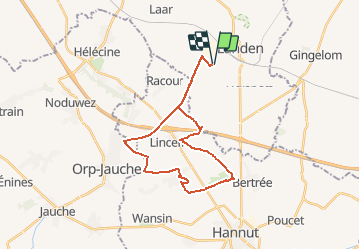
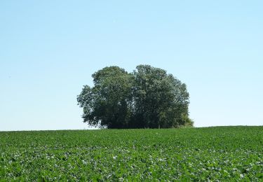
Trail Horseback riding of 25 km to be discovered at Flanders, Flemish Brabant, Landen. This trail is proposed by Arte Liège.
Description
Landen, Lincent, Avernas, Grand-Hallet, Crécou, Landen.
Par un maximum de chemins naturels.
Pour chevaux, vtt, marcheurs, ...
Départ au parking de la Tombe de Pépin, mais autres possibilités sur le parcours.
Positioning
Country:
Belgium
Region :
Flanders
Department/Province :
Flemish Brabant
Municipality :
Landen
Location:
Landen
Start:(Dec)
Start:(UTM)
645532 ; 5623576 (31U) N.
Comments
Trails nearby
![Trail Walking Landen - La vallée du ruisseau Mombeek : la réserve naturelle De Beemden à Attenhoven - Photo](https://media.geolcdn.com/t/375/260/0867a30e-1e7f-408e-b385-03c73569b3c8.jpeg&format=jpg&maxdim=2)
![Walking Walking](https://static1.geolcdn.com/sitytour/trail-icons/101.png)
La vallée du ruisseau Mombeek : la réserve naturelle De Beemden à Attenhoven
Walking
Easy
Landen,
Flanders,
Flemish Brabant,
Belgium
![](/images/other/stat-length.png)
3.3 km | 3.5 km-effort
47min
![](https://static1.geolcdn.com/siteimages/upload/files/16400158638029165_repeat_loop_refresh_sync_direction_icon.png)
Yes
![Trail On foot Landen - Toegankelijke Zevenbronnenwandeling - Photo](https://media.geolcdn.com/t/375/260/e270a4ca-93be-4e8c-87ad-1e5a316b4c2c.jpeg&format=jpg&maxdim=2)
![On foot On foot](https://static1.geolcdn.com/sitytour/trail-icons/100.png)
Toegankelijke Zevenbronnenwandeling
On foot
Easy
(1)
Landen,
Flanders,
Flemish Brabant,
Belgium
![](/images/other/stat-length.png)
3.7 km | 4.1 km-effort
55min
![](https://static1.geolcdn.com/siteimages/upload/files/16400158638029165_repeat_loop_refresh_sync_direction_icon.png)
Yes
![Trail On foot Landen - Pepijn wandeling - Photo](https://media.geolcdn.com/t/375/260/04bfadaa-9170-4dac-b8db-21a0ef031509.jpeg&format=jpg&maxdim=2)
![On foot On foot](https://static1.geolcdn.com/sitytour/trail-icons/100.png)
Pepijn wandeling
On foot
Easy
Landen,
Flanders,
Flemish Brabant,
Belgium
![](/images/other/stat-length.png)
8.8 km | 9.5 km-effort
2h 10min
![](https://static1.geolcdn.com/siteimages/upload/files/16400158638029165_repeat_loop_refresh_sync_direction_icon.png)
No
![Trail On foot Landen - Landen - Sint Truiden 19 km - Photo](https://media.geolcdn.com/t/375/260/bf044a6c-6238-4c32-8296-16f7797f4bb6.jpg&format=jpg&maxdim=2)
![On foot On foot](https://static1.geolcdn.com/sitytour/trail-icons/100.png)
Landen - Sint Truiden 19 km
On foot
Medium
Landen,
Flanders,
Flemish Brabant,
Belgium
![](/images/other/stat-length.png)
19.8 km | 22 km-effort
4h 53min
![](https://static1.geolcdn.com/siteimages/upload/files/16400158638029165_repeat_loop_refresh_sync_direction_icon.png)
No
![Trail Walking Lincent - Tracé - Photo](https://media.geolcdn.com/t/375/260/faf80b17-1570-4cc5-b12c-6b2c2f9baa8b.jpeg&format=jpg&maxdim=2)
![Walking Walking](https://static1.geolcdn.com/sitytour/trail-icons/101.png)
![Trail Walking Landen - Neerlanden Panbrugge (PVDB) - Photo](https://media.geolcdn.com/t/375/260/49a49a33-c9ef-40ee-aaf2-6a59b37a83cb.jpg&format=jpg&maxdim=2)
![Walking Walking](https://static1.geolcdn.com/sitytour/trail-icons/101.png)
Neerlanden Panbrugge (PVDB)
Walking
Medium
Landen,
Flanders,
Flemish Brabant,
Belgium
![](/images/other/stat-length.png)
12 km | 13.1 km-effort
2h 39min
![](https://static1.geolcdn.com/siteimages/upload/files/16400158638029165_repeat_loop_refresh_sync_direction_icon.png)
Yes
![Trail On foot Landen - Vestenwandeling - Photo](https://media.geolcdn.com/t/375/260/7b550fc9-d54c-4f55-8710-1b4d34ad5942.jpeg&format=jpg&maxdim=2)
![On foot On foot](https://static1.geolcdn.com/sitytour/trail-icons/100.png)
Vestenwandeling
On foot
Easy
Landen,
Flanders,
Flemish Brabant,
Belgium
![](/images/other/stat-length.png)
3.4 km | 3.8 km-effort
51min
![](https://static1.geolcdn.com/siteimages/upload/files/16400158638029165_repeat_loop_refresh_sync_direction_icon.png)
Yes
![Trail On foot Gingelom - Zevenbronnenwandeling - Photo](https://media.geolcdn.com/t/375/260/cce0d8a5-eac8-41b0-85bf-74be563b7e67.jpeg&format=jpg&maxdim=2)
![On foot On foot](https://static1.geolcdn.com/sitytour/trail-icons/100.png)
Zevenbronnenwandeling
On foot
Easy
Gingelom,
Flanders,
Limburg,
Belgium
![](/images/other/stat-length.png)
9.7 km | 10.6 km-effort
2h 24min
![](https://static1.geolcdn.com/siteimages/upload/files/16400158638029165_repeat_loop_refresh_sync_direction_icon.png)
Yes
![Road bike Road bike](https://static1.geolcdn.com/sitytour/trail-icons/201.png)
HLN Geetbets
Road bike
Medium
Landen,
Flanders,
Flemish Brabant,
Belgium
![](/images/other/stat-length.png)
49 km | 53 km-effort
3h 48min
![](https://static1.geolcdn.com/siteimages/upload/files/16400158638029165_repeat_loop_refresh_sync_direction_icon.png)
Yes