![](/images/other/stat-length.png)
![Trail Walking Viriville - la voie du tram - Photo](https://media.geolcdn.com/t/1900/400/ext.pjpeg?maxdim=2&url=https%3A%2F%2Fstatic1.geolcdn.com%2Fsiteimages%2Fupload%2Ffiles%2F1553511878bg_sport_marche.png)
la voie du tram
raymondfn
User
![Length](/images/other/stat-length.png)
Length
8.8 km
![Max alt](https://static1.geolcdn.com/siteimages/upload/files/1508320355ic_sort_altitude_max_24dp.png)
Max alt
512 m
![Uphill gradient](https://static1.geolcdn.com/siteimages/upload/files/1508320355ic_sort_den_pos_24dp.png)
Uphill gradient
176 m
![Km-Effort](/images/other/stat-length.png)
Km-Effort
11.2 km
![Min alt](https://static1.geolcdn.com/siteimages/upload/files/1508320355ic_sort_altitude_min_24dp.png)
Min alt
357 m
![Downhill gradient](https://static1.geolcdn.com/siteimages/upload/files/1508320355ic_sort_den_neg_24dp.png)
Downhill gradient
174 m
![Boucle](https://static1.geolcdn.com/siteimages/upload/files/16400158638029165_repeat_loop_refresh_sync_direction_icon.png)
Boucle
Yes
Creation date :
2020-10-04 14:38:29.104
Updated on :
2020-10-04 17:07:55.71
![Walking](https://static1.geolcdn.com/sitytour/trail-icons/101.png)
2h24
Difficulty : Medium
![Scan this QR Code to open this trail in the SityTrail application](https://capi.geolives.com/qq0zvz2zws4bq2lad0pu/sitytour/trails/2568521/qr.png?size=200)
FREE GPS app for hiking
About
Trail Walking of 8.8 km to be discovered at Auvergne-Rhône-Alpes, Isère, Viriville. This trail is proposed by raymondfn.
Description
Cette balade emprunte en partie l'ancienne voie du tram qui reliait au début du 20ème siècle, Lyon à Saint-Marcellin.
Départ : près de l'ancienne gare de Viriville, aujourd'hui transformé en centre médical.
Positioning
Country:
France
Region :
Auvergne-Rhône-Alpes
Department/Province :
Isère
Municipality :
Viriville
Location:
Unknown
Start:(Dec)
Start:(UTM)
672902 ; 5020438 (31T) N.
Comments
Trails nearby
![Trail Walking Marnans - Marnans, les Mermes - Photo](https://media.geolcdn.com/t/375/260/ext.jpg?maxdim=2&url=https%3A%2F%2Fstatic1.geolcdn.com%2Fsiteimages%2Fupload%2Ffiles%2F1553511878bg_sport_marche.png)
![Walking Walking](https://static1.geolcdn.com/sitytour/trail-icons/101.png)
Marnans, les Mermes
Walking
Easy
(1)
Marnans,
Auvergne-Rhône-Alpes,
Isère,
France
![](/images/other/stat-length.png)
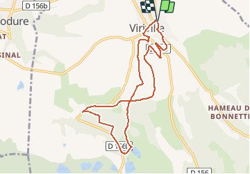
9.2 km | 12.3 km-effort
3h 20min
![](https://static1.geolcdn.com/siteimages/upload/files/16400158638029165_repeat_loop_refresh_sync_direction_icon.png)
Yes
![Trail Walking Châtenay - SityTrail - RS-Chatenay-Le Mont Joyeux - Photo](https://media.geolcdn.com/t/375/260/ext.jpg?maxdim=2&url=https%3A%2F%2Fstatic1.geolcdn.com%2Fsiteimages%2Fupload%2Ffiles%2F1553511878bg_sport_marche.png)
![Walking Walking](https://static1.geolcdn.com/sitytour/trail-icons/101.png)
SityTrail - RS-Chatenay-Le Mont Joyeux
Walking
Easy
(1)
Châtenay,
Auvergne-Rhône-Alpes,
Isère,
France
![](/images/other/stat-length.png)
4.2 km | 5.4 km-effort
1h 13min
![](https://static1.geolcdn.com/siteimages/upload/files/16400158638029165_repeat_loop_refresh_sync_direction_icon.png)
Yes
![Trail Walking Saint-Siméon-de-Bressieux - Canyon des Gueulards - Photo](https://media.geolcdn.com/t/375/260/c7d57c62-b904-4931-b0d4-bac5886558e5.jpg&format=jpg&maxdim=2)
![Walking Walking](https://static1.geolcdn.com/sitytour/trail-icons/101.png)
Canyon des Gueulards
Walking
Medium
Saint-Siméon-de-Bressieux,
Auvergne-Rhône-Alpes,
Isère,
France
![](/images/other/stat-length.png)
73 km | 118 km-effort
6h 24min
![](https://static1.geolcdn.com/siteimages/upload/files/16400158638029165_repeat_loop_refresh_sync_direction_icon.png)
No
![Trail Walking Marnans - Marnan les lacs - Photo](https://media.geolcdn.com/t/375/260/b7c582f1-5150-4314-954d-5ee0e303322a.jpg&format=jpg&maxdim=2)
![Walking Walking](https://static1.geolcdn.com/sitytour/trail-icons/101.png)
Marnan les lacs
Walking
Medium
Marnans,
Auvergne-Rhône-Alpes,
Isère,
France
![](/images/other/stat-length.png)
12.5 km | 16.5 km-effort
3h 56min
![](https://static1.geolcdn.com/siteimages/upload/files/16400158638029165_repeat_loop_refresh_sync_direction_icon.png)
Yes
![Trail Walking Châtenay - Chatenay par la Combe Bajat - Photo](https://media.geolcdn.com/t/375/260/ext.jpg?maxdim=2&url=https%3A%2F%2Fservices.sitytrail.com%2FGeolivesWS%2FDownloadMedia.ashx%3FTrailID%3D759950%26Media%3Dfix__20170525174315.jpg)
![Walking Walking](https://static1.geolcdn.com/sitytour/trail-icons/101.png)
Chatenay par la Combe Bajat
Walking
Medium
Châtenay,
Auvergne-Rhône-Alpes,
Isère,
France
![](/images/other/stat-length.png)
13.3 km | 18.2 km-effort
3h 30min
![](https://static1.geolcdn.com/siteimages/upload/files/16400158638029165_repeat_loop_refresh_sync_direction_icon.png)
Yes
![Trail Walking Saint-Siméon-de-Bressieux - autour de st Siméon de bressieux - Photo](https://media.geolcdn.com/t/375/260/aa3bd6c5-0b0e-4a70-b6b3-c4311da84ab3.jpg&format=jpg&maxdim=2)
![Walking Walking](https://static1.geolcdn.com/sitytour/trail-icons/101.png)
autour de st Siméon de bressieux
Walking
Difficult
Saint-Siméon-de-Bressieux,
Auvergne-Rhône-Alpes,
Isère,
France
![](/images/other/stat-length.png)
21 km | 28 km-effort
4h 59min
![](https://static1.geolcdn.com/siteimages/upload/files/16400158638029165_repeat_loop_refresh_sync_direction_icon.png)
Yes
![Trail Walking Viriville - rando Yakia Viriville - Photo](https://media.geolcdn.com/t/375/260/ext.jpg?maxdim=2&url=https%3A%2F%2Fstatic1.geolcdn.com%2Fsiteimages%2Fupload%2Ffiles%2F1553511878bg_sport_marche.png)
![Walking Walking](https://static1.geolcdn.com/sitytour/trail-icons/101.png)
rando Yakia Viriville
Walking
Very difficult
Viriville,
Auvergne-Rhône-Alpes,
Isère,
France
![](/images/other/stat-length.png)
15.6 km | 19.6 km-effort
4h 32min
![](https://static1.geolcdn.com/siteimages/upload/files/16400158638029165_repeat_loop_refresh_sync_direction_icon.png)
Yes
![Trail Walking Viriville - RD-Viriville-Gallix&Mitifiot - Photo](https://media.geolcdn.com/t/375/260/ext.jpg?maxdim=2&url=https%3A%2F%2Fstatic1.geolcdn.com%2Fsiteimages%2Fupload%2Ffiles%2F1553511878bg_sport_marche.png)
![Walking Walking](https://static1.geolcdn.com/sitytour/trail-icons/101.png)
RD-Viriville-Gallix&Mitifiot
Walking
Medium
Viriville,
Auvergne-Rhône-Alpes,
Isère,
France
![](/images/other/stat-length.png)
8.5 km | 11 km-effort
2h 11min
![](https://static1.geolcdn.com/siteimages/upload/files/16400158638029165_repeat_loop_refresh_sync_direction_icon.png)
Yes
![Trail Walking Viriville - RD-Viriville-Les-Ruines-de-Grolée - Photo](https://media.geolcdn.com/t/375/260/ext.jpg?maxdim=2&url=https%3A%2F%2Fstatic1.geolcdn.com%2Fsiteimages%2Fupload%2Ffiles%2F1553511878bg_sport_marche.png)
![Walking Walking](https://static1.geolcdn.com/sitytour/trail-icons/101.png)
RD-Viriville-Les-Ruines-de-Grolée
Walking
Medium
Viriville,
Auvergne-Rhône-Alpes,
Isère,
France
![](/images/other/stat-length.png)
6.5 km | 8.2 km-effort
1h 25min
![](https://static1.geolcdn.com/siteimages/upload/files/16400158638029165_repeat_loop_refresh_sync_direction_icon.png)
Yes