![](/images/other/stat-length.png)
![Trail Walking Étalle - Vance Adeps 2020 - Photo](https://media.geolcdn.com/t/1900/400/ext.pjpeg?maxdim=2&url=https%3A%2F%2Fstatic1.geolcdn.com%2Fsiteimages%2Fupload%2Ffiles%2F1553511878bg_sport_marche.png)
Vance Adeps 2020
fra_depoorter
User
![Length](/images/other/stat-length.png)
Length
11 km
![Max alt](https://static1.geolcdn.com/siteimages/upload/files/1508320355ic_sort_altitude_max_24dp.png)
Max alt
369 m
![Uphill gradient](https://static1.geolcdn.com/siteimages/upload/files/1508320355ic_sort_den_pos_24dp.png)
Uphill gradient
108 m
![Km-Effort](/images/other/stat-length.png)
Km-Effort
12.4 km
![Min alt](https://static1.geolcdn.com/siteimages/upload/files/1508320355ic_sort_altitude_min_24dp.png)
Min alt
333 m
![Downhill gradient](https://static1.geolcdn.com/siteimages/upload/files/1508320355ic_sort_den_neg_24dp.png)
Downhill gradient
106 m
![Boucle](https://static1.geolcdn.com/siteimages/upload/files/16400158638029165_repeat_loop_refresh_sync_direction_icon.png)
Boucle
Yes
Creation date :
2020-10-03 07:49:34.937
Updated on :
2020-10-03 13:25:42.654
![Walking](https://static1.geolcdn.com/sitytour/trail-icons/101.png)
2h23
Difficulty : Easy
![Scan this QR Code to open this trail in the SityTrail application](https://capi.geolives.com/qq0zvz2zws4bq2lad0pu/sitytour/trails/2567554/qr.png?size=200)
FREE GPS app for hiking
About
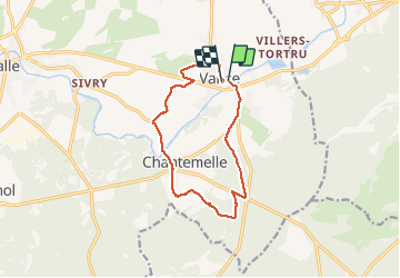
Trail Walking of 11 km to be discovered at Wallonia, Luxembourg, Étalle. This trail is proposed by fra_depoorter.
Description
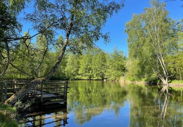
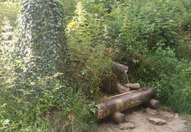
Merveilleuse randonnée, essentiellement sous bois sans difficulté. Un peu de tarmac au départ et en fin de parcours; court passage boueux, débardage récent.
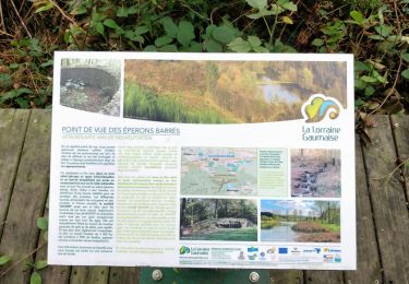
Traversée de Chantemelle très plaisante. A ne pas manquer. Merci aux organisateurs dévoués.
Positioning
Country:
Belgium
Region :
Wallonia
Department/Province :
Luxembourg
Municipality :
Étalle
Location:
Vance
Start:(Dec)
Start:(UTM)
692563 ; 5505338 (31U) N.
Comments
Trails nearby
![Trail Mountain bike Étalle - O2bikers_26_etalle - Photo](https://media.geolcdn.com/t/375/260/ext.jpg?maxdim=2&url=https%3A%2F%2Fstatic1.geolcdn.com%2Fsiteimages%2Fupload%2Ffiles%2F1524743154velo.jpg)
![Mountain bike Mountain bike](https://static1.geolcdn.com/sitytour/trail-icons/202.png)
O2bikers_26_etalle
Mountain bike
Very easy
(1)
Étalle,
Wallonia,
Luxembourg,
Belgium
![](/images/other/stat-length.png)
22 km | 27 km-effort
3h 0min
![](https://static1.geolcdn.com/siteimages/upload/files/16400158638029165_repeat_loop_refresh_sync_direction_icon.png)
Yes
![Trail On foot Attert - Thiaumont TH01 - Photo](https://media.geolcdn.com/t/375/260/ext.jpg?maxdim=2&url=https%3A%2F%2Fpivotmedia.tourismewallonie.be%2FOTH-A0-0068-286F%2FOTH-A0-0068-286F.jpg)
![On foot On foot](https://static1.geolcdn.com/sitytour/trail-icons/100.png)
Thiaumont TH01
On foot
Easy
(1)
Attert,
Wallonia,
Luxembourg,
Belgium
![](/images/other/stat-length.png)
7.1 km | 8.8 km-effort
2h 0min
![](https://static1.geolcdn.com/siteimages/upload/files/16400158638029165_repeat_loop_refresh_sync_direction_icon.png)
Yes
![Trail Walking Étalle - GAUME Boucle vers la vallee de la Rougeau - Photo](https://media.geolcdn.com/t/375/260/ext.jpg?maxdim=2&url=https%3A%2F%2Fstatic1.geolcdn.com%2Fsiteimages%2Fupload%2Ffiles%2F1553511878bg_sport_marche.png)
![Walking Walking](https://static1.geolcdn.com/sitytour/trail-icons/101.png)
GAUME Boucle vers la vallee de la Rougeau
Walking
Easy
(3)
Étalle,
Wallonia,
Luxembourg,
Belgium
![](/images/other/stat-length.png)
5.6 km | 7.1 km-effort
1h 32min
![](https://static1.geolcdn.com/siteimages/upload/files/16400158638029165_repeat_loop_refresh_sync_direction_icon.png)
Yes
![Trail Walking Saint-Léger - GAUME Balade dans les dunes de chatillon - Photo](https://media.geolcdn.com/t/375/260/ext.jpg?maxdim=2&url=https%3A%2F%2Fstatic1.geolcdn.com%2Fsiteimages%2Fupload%2Ffiles%2F1553511878bg_sport_marche.png)
![Walking Walking](https://static1.geolcdn.com/sitytour/trail-icons/101.png)
GAUME Balade dans les dunes de chatillon
Walking
Very easy
(1)
Saint-Léger,
Wallonia,
Luxembourg,
Belgium
![](/images/other/stat-length.png)
3.6 km | 4.4 km-effort
58min
![](https://static1.geolcdn.com/siteimages/upload/files/16400158638029165_repeat_loop_refresh_sync_direction_icon.png)
Yes
![Trail Walking Étalle - Chantemelle la tranchée des portes - Photo](https://media.geolcdn.com/t/375/260/61188bc8-d295-4809-ba0b-7ca5757e1f85.jpg&format=jpg&maxdim=2)
![Walking Walking](https://static1.geolcdn.com/sitytour/trail-icons/101.png)
Chantemelle la tranchée des portes
Walking
Easy
Étalle,
Wallonia,
Luxembourg,
Belgium
![](/images/other/stat-length.png)
10.8 km | 12.6 km-effort
2h 30min
![](https://static1.geolcdn.com/siteimages/upload/files/16400158638029165_repeat_loop_refresh_sync_direction_icon.png)
Yes
![Trail On foot Étalle - La Stabuloise - Photo](https://media.geolcdn.com/t/375/260/ext.jpg?maxdim=2&url=https%3A%2F%2Fpivotmedia.tourismewallonie.be%2FOTH-A0-006F-3F6K%2FOTH-A0-006F-3F6K.jpg)
![On foot On foot](https://static1.geolcdn.com/sitytour/trail-icons/100.png)
La Stabuloise
On foot
Easy
Étalle,
Wallonia,
Luxembourg,
Belgium
![](/images/other/stat-length.png)
13.5 km | 15.5 km-effort
3h 30min
![](https://static1.geolcdn.com/siteimages/upload/files/16400158638029165_repeat_loop_refresh_sync_direction_icon.png)
Yes
![Trail Mountain bike Saint-Léger - Forêt de Gaume depuis Chatillon VTT - Photo](https://media.geolcdn.com/t/375/260/578117db-8d17-4c92-947f-fe85b4198750.jpg&format=jpg&maxdim=2)
![Mountain bike Mountain bike](https://static1.geolcdn.com/sitytour/trail-icons/202.png)
Forêt de Gaume depuis Chatillon VTT
Mountain bike
Medium
Saint-Léger,
Wallonia,
Luxembourg,
Belgium
![](/images/other/stat-length.png)
24 km | 28 km-effort
1h 37min
![](https://static1.geolcdn.com/siteimages/upload/files/16400158638029165_repeat_loop_refresh_sync_direction_icon.png)
Yes
![Trail Walking Étalle - Trou des portes et Dent du Chien - Photo](https://media.geolcdn.com/t/375/260/c1311f72-be86-4a53-93a3-48736aa4c01b.jpg&format=jpg&maxdim=2)
![Walking Walking](https://static1.geolcdn.com/sitytour/trail-icons/101.png)
Trou des portes et Dent du Chien
Walking
Very easy
(1)
Étalle,
Wallonia,
Luxembourg,
Belgium
![](/images/other/stat-length.png)
8.9 km | 12.5 km-effort
2h 13min
![](https://static1.geolcdn.com/siteimages/upload/files/16400158638029165_repeat_loop_refresh_sync_direction_icon.png)
No
![Trail Walking Étalle - chantemelle - Photo](https://media.geolcdn.com/t/375/260/ext.jpg?maxdim=2&url=https%3A%2F%2Fstatic1.geolcdn.com%2Fsiteimages%2Fupload%2Ffiles%2F1553511878bg_sport_marche.png)
![Walking Walking](https://static1.geolcdn.com/sitytour/trail-icons/101.png)
chantemelle
Walking
Very easy
(1)
Étalle,
Wallonia,
Luxembourg,
Belgium
![](/images/other/stat-length.png)
6.3 km | 7.7 km-effort
1h 40min
![](https://static1.geolcdn.com/siteimages/upload/files/16400158638029165_repeat_loop_refresh_sync_direction_icon.png)
Yes