Trail Walking Ajat - Ajat Beauzens 13 km - Photo

Ajat Beauzens 13 km

 YV24
YV24

User

© OpenStreetMap contributors
Length
Length
12.9 km
Max alt
Max alt
252 m
Uphill gradient
Uphill gradient
210 m
Km-Effort
Km-Effort  
15.7 km
Min alt
Min alt
163 m
Downhill gradient
Downhill gradient
211 m
Boucle
Boucle
Yes
Creation date :
2014-12-10 00:00:00.0
Updated on :
2019-06-10 17:18:33.971

(1 Reviews)

Walking
Walking
3h24
Difficulty : Easy

Scan this QR Code to open this trail in the SityTrail application

FREE GPS app for hiking

Logo SityTrail SityTrail

IGN / Geographical institutes

Download SityTrail from the App Store Download SityTrail from Google Play

Logo SityTrail SityTrail World

The world is yours!

Download SityTrail from the App Store Download SityTrail from Google Play Download SityTrail on Huawei AppGallery

About

Trail Walking of 12.9 km to be discovered at New Aquitaine, Dordogne, Ajat. This trail is proposed by YV24.

Description

Attention, sauf qqs portions, circuit non balisé

Elevation profile

Positioning

Country:
France
Region :
New Aquitaine
Department/Province :
Dordogne
Municipality :
Ajat
Location:
Unknown
Start:(UTM)
344052 ; 5002222 (31T) N.

Comments

Please log in to post a review or rate the element


bien au début,mais le chemin s'est perdu au 8 km,300 mètres après le passage au dessus de l'autoroute


Trails nearby

Trail Walking Limeyrat - limeyrat - Photo
Walking
fab0202

Walking

Easy
Limeyrat, New Aquitaine, Dordogne, France
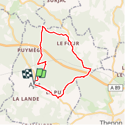
11.1 km | 13.3 km-effort
2h 48min
Yes
Trail Mountain bike Ajat - reco 3 romain thenon - Photo
Mountain bike
phil24

Mountain bike

Easy
Ajat, New Aquitaine, Dordogne, France
19.1 km | 23 km-effort
2h 3min
Yes
Trail Mountain bike Ajat - reco 3 romain thenon - Photo
Mountain bike
phil24

Mountain bike

Easy
Ajat, New Aquitaine, Dordogne, France
19.1 km | 23 km-effort
2h 3min
Yes
Trail Walking Montagnac-d'Auberoche - Boucle de la fontaine Marceau ( Montagnac d’ Auberoche)  - Photo
Walking
Marc 24

Walking

Easy
Montagnac-d'Auberoche, New Aquitaine, Dordogne, France
6.9 km | 8.6 km-effort
2h 9min
Yes
Trail Electric bike Brouchaud - php Blis & Born - Photo
Electric bike
phplatteau44

Electric bike

Very easy
Brouchaud, New Aquitaine, Dordogne, France
31 km | 37 km-effort
2h 11min
No
Trail Road bike Brouchaud - php Mayac - Photo
Road bike
phplatteau44

Road bike

Very difficult
Brouchaud, New Aquitaine, Dordogne, France
35 km | 42 km-effort
4h 47min
Yes
Trail Mountain bike Thenon - Sortie Thenon - Photo
Mountain bike
guycouderc

Mountain bike

Medium
Thenon, New Aquitaine, Dordogne, France
25 km | 30 km-effort
1h 59min
Yes
Trail Walking Ajat - Beauzens Rozas La Rolfie 12km - Photo
Walking
YV24

Walking

Easy
Ajat, New Aquitaine, Dordogne, France
11.7 km | 14.3 km-effort
2h 54min
Yes
Trail Walking Brouchaud - Rousselle - Photo
Walking
phplatteau44

Walking

Very easy
Brouchaud, New Aquitaine, Dordogne, France
5.6 km | 7.2 km-effort
1h 35min
Yes


Close
My subscriptions