Trail Walking Le Gua - Le Balcon des Petits Amieux - Photo

Le Balcon des Petits Amieux

 patjobou
patjobou

User

© OpenStreetMap contributors
Length
Length
11.9 km
Max alt
Max alt
1054 m
Uphill gradient
Uphill gradient
571 m
Km-Effort
Km-Effort  
19.5 km
Min alt
Min alt
540 m
Downhill gradient
Downhill gradient
580 m
Boucle
Boucle
Yes
Creation date :
2020-10-01 07:23:13.146
Updated on :
2020-10-01 14:24:40.859

(0 Reviews)

Walking
Walking
4h30
Difficulty : Easy

Scan this QR Code to open this trail in the SityTrail application

FREE GPS app for hiking

Logo SityTrail SityTrail

IGN / Geographical institutes

Download SityTrail from the App Store Download SityTrail from Google Play

Logo SityTrail SityTrail World

The world is yours!

Download SityTrail from the App Store Download SityTrail from Google Play Download SityTrail on Huawei AppGallery

About

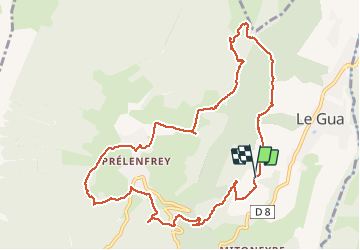
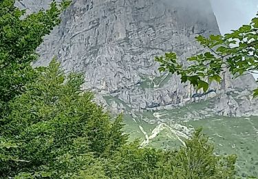
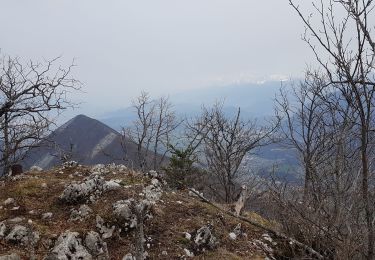
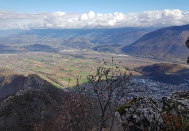
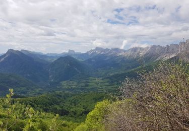
Trail Walking of 11.9 km to be discovered at Auvergne-Rhône-Alpes, Isère, Le Gua. This trail is proposed by patjobou.

Description

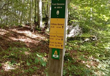
Le chemin vers la Croix de Chateauvieux existe bien, du moins au départ.

Elevation profile

Photos

Positioning

Country:
France
Region :
Auvergne-Rhône-Alpes
Department/Province :
Isère
Municipality :
Le Gua
Location:
Unknown
Start:(UTM)
707540 ; 4987921 (31T) N.

Trails nearby

Trail Walking Château-Bernard - la soldanelle - Photo
Walking
cmarit

Walking

Easy
(1)
Château-Bernard, Auvergne-Rhône-Alpes, Isère, France
6.1 km | 10.8 km-effort
3h 17min
No
Trail Walking Villard-de-Lans - La petite sœur Sophie - Photo
Walking
GUIDE
nadd73

Walking

Difficult
Villard-de-Lans, Auvergne-Rhône-Alpes, Isère, France
8 km | 15.7 km-effort
4h 23min
Yes
Trail Walking Vif - la ferme oriol en circuit  - Photo
Walking
Youcef Atallah

Walking

Very difficult
Vif, Auvergne-Rhône-Alpes, Isère, France
13.7 km | 24 km-effort
3h 15min
Yes
Trail Walking Château-Bernard - tête des chaudières et rocher de la Balme  - Photo
Walking
paulin bruno

Walking

Medium
Château-Bernard, Auvergne-Rhône-Alpes, Isère, France
19.2 km | 36 km-effort
7h 22min
Yes
Trail Walking Château-Bernard - sous pas Balme de Arzelier - Photo
Walking
Ninie38MD

Walking

Medium
Château-Bernard, Auvergne-Rhône-Alpes, Isère, France
12.5 km | 21 km-effort
6h 11min
Yes
Trail Walking Le Gua - Un tour de L'Eperrimont par le sommet ! - Photo
Walking
patjobou

Walking

Medium
Le Gua, Auvergne-Rhône-Alpes, Isère, France
14.6 km | 27 km-effort
6h 5min
Yes
Trail Walking Le Gua - Le Pieu depuis Les Petits Amieux - Photo
Walking
patjobou

Walking

Medium
Le Gua, Auvergne-Rhône-Alpes, Isère, France
11.8 km | 22 km-effort
4h 54min
Yes
Trail Walking Le Gua - Tour des arêtes du Gerbier - Photo
Walking
Emelle

Walking

Difficult
Le Gua, Auvergne-Rhône-Alpes, Isère, France
14.2 km | 27 km-effort
7h 21min
Yes
Trail Walking Château-Bernard - Le Pas de La Balme depuis le Col de l Arzelier  - Photo
Walking
patjobou

Walking

Difficult
Château-Bernard, Auvergne-Rhône-Alpes, Isère, France
14 km | 27 km-effort
5h 40min
Yes


Close
My subscriptions