![](/images/other/stat-length.png)
![Trail Walking La Valette - Cabane ONF du Poyet, depuis la Valette - Photo](https://media.geolcdn.com/t/1900/400/93222bd8-8947-41da-825b-3739799a19df.jpg&format=pjpeg&maxdim=2)
Cabane ONF du Poyet, depuis la Valette
cmarit
User
![Length](/images/other/stat-length.png)
![Max alt](https://static1.geolcdn.com/siteimages/upload/files/1508320355ic_sort_altitude_max_24dp.png)
![Uphill gradient](https://static1.geolcdn.com/siteimages/upload/files/1508320355ic_sort_den_pos_24dp.png)
![Km-Effort](/images/other/stat-length.png)
![Min alt](https://static1.geolcdn.com/siteimages/upload/files/1508320355ic_sort_altitude_min_24dp.png)
![Downhill gradient](https://static1.geolcdn.com/siteimages/upload/files/1508320355ic_sort_den_neg_24dp.png)
![Boucle](https://static1.geolcdn.com/siteimages/upload/files/16400158638029165_repeat_loop_refresh_sync_direction_icon.png)
![Walking](https://static1.geolcdn.com/sitytour/trail-icons/101.png)
2h40
Difficulty : Medium
![Scan this QR Code to open this trail in the SityTrail application](https://capi.geolives.com/qq0zvz2zws4bq2lad0pu/sitytour/trails/2563098/qr.png?size=200)
FREE GPS app for hiking
About
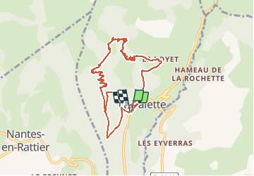
Trail Walking of 10.1 km to be discovered at Auvergne-Rhône-Alpes, Isère, La Valette. This trail is proposed by cmarit.
Description
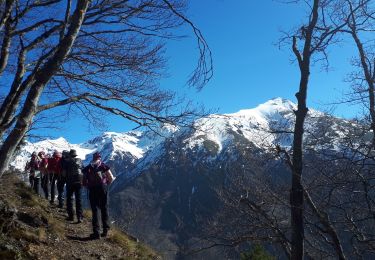
Belle randonnée hivernale en ce 27 sept!
30cm de neige à la cabane (1614m)
On est 5 et on est bien, quoique un peu humide!
Heureusement Christian nous a fait du feu dans la cabane pour notre pique-nique...chaud!
Jolie boucle , faisable en raquettes car toute en Forêt.
(J'ai tracé la fin du parcours a posteriori, car ma batterie était trop faible.
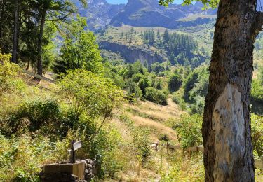
Quand on a quitté la route en se rapprochant de la Valette, nous avons emprunté un sentier non balisé mais très bien tracé (forestiers) et très agréable car sans cailloux avec un tapis d'aiguilles de résineux;
Le temps donné ne tient pas compte de la fin du parcours ( 1h?)
Positioning
Comments
Trails nearby
![Trail Walking Lavaldens - Le Mollard - Lac Rif Bruyant 01/10/2023 - Photo](https://media.geolcdn.com/t/375/260/19c40cca-c1c5-4cd2-837c-cfeae0558b05.jpg&format=jpg&maxdim=2)
![Walking Walking](https://static1.geolcdn.com/sitytour/trail-icons/101.png)
Walking
![](/images/other/stat-length.png)
![](https://static1.geolcdn.com/siteimages/upload/files/16400158638029165_repeat_loop_refresh_sync_direction_icon.png)
![Trail Walking Lavaldens - 2022-07-20_17h08m14_Rif Bruyant - Photo](https://media.geolcdn.com/t/375/260/ext.jpg?maxdim=2&url=https%3A%2F%2Fstatic1.geolcdn.com%2Fsiteimages%2Fupload%2Ffiles%2F1553511878bg_sport_marche.png)
![Walking Walking](https://static1.geolcdn.com/sitytour/trail-icons/101.png)
Walking
![](/images/other/stat-length.png)
![](https://static1.geolcdn.com/siteimages/upload/files/16400158638029165_repeat_loop_refresh_sync_direction_icon.png)
![Trail Touring skiing Saint-Honoré - Le perollier, le Grand Serre - Photo](https://media.geolcdn.com/t/375/260/8f028379-4012-403e-a754-1ba5ea0046bf.jpg&format=jpg&maxdim=2)
![Touring skiing Touring skiing](https://static1.geolcdn.com/sitytour/trail-icons/503.png)
Touring skiing
![](/images/other/stat-length.png)
![](https://static1.geolcdn.com/siteimages/upload/files/16400158638029165_repeat_loop_refresh_sync_direction_icon.png)
![Trail Touring skiing Saint-Honoré - Tabor de la Mûre - Photo](https://media.geolcdn.com/t/375/260/20d14802-7ff5-4d88-956a-7b9a995b765e.jpg&format=jpg&maxdim=2)
![Touring skiing Touring skiing](https://static1.geolcdn.com/sitytour/trail-icons/503.png)
Touring skiing
![](/images/other/stat-length.png)
![](https://static1.geolcdn.com/siteimages/upload/files/16400158638029165_repeat_loop_refresh_sync_direction_icon.png)
![Trail Walking Lavaldens - Rif Bruyant - Photo](https://media.geolcdn.com/t/375/260/8dcecefd-d7fb-4568-9f12-c9e9cddea53d.jpg&format=jpg&maxdim=2)
![Walking Walking](https://static1.geolcdn.com/sitytour/trail-icons/101.png)
Walking
![](/images/other/stat-length.png)
![](https://static1.geolcdn.com/siteimages/upload/files/16400158638029165_repeat_loop_refresh_sync_direction_icon.png)
![Trail Walking Lavaldens - Lavaldens 400 + - Photo](https://media.geolcdn.com/t/375/260/45b87e76-5e2f-44a8-8782-86a98ed8c427.jpg&format=jpg&maxdim=2)
![Walking Walking](https://static1.geolcdn.com/sitytour/trail-icons/101.png)
Walking
![](/images/other/stat-length.png)
![](https://static1.geolcdn.com/siteimages/upload/files/16400158638029165_repeat_loop_refresh_sync_direction_icon.png)
![Trail Walking Saint-Honoré - Le Grand Serre - Photo](https://media.geolcdn.com/t/375/260/ea564edc-db3e-467a-9f34-8236705096bb.jpg&format=jpg&maxdim=2)
![Walking Walking](https://static1.geolcdn.com/sitytour/trail-icons/101.png)
Walking
![](/images/other/stat-length.png)
![](https://static1.geolcdn.com/siteimages/upload/files/16400158638029165_repeat_loop_refresh_sync_direction_icon.png)
![Trail Walking La Valette - La cabane de Poyet en circuit - Photo](https://media.geolcdn.com/t/375/260/5619e671-6185-4bcc-8e40-810ed807016c.jpg&format=jpg&maxdim=2)
![Walking Walking](https://static1.geolcdn.com/sitytour/trail-icons/101.png)
Walking
![](/images/other/stat-length.png)
![](https://static1.geolcdn.com/siteimages/upload/files/16400158638029165_repeat_loop_refresh_sync_direction_icon.png)
![Trail Walking Saint-Honoré - Tabor de Matheysine en circuit - Photo](https://media.geolcdn.com/t/375/260/eac49f4f-8e36-400c-8bb1-5aa35be03a49.jpg&format=jpg&maxdim=2)
![Walking Walking](https://static1.geolcdn.com/sitytour/trail-icons/101.png)
Walking
![](/images/other/stat-length.png)
![](https://static1.geolcdn.com/siteimages/upload/files/16400158638029165_repeat_loop_refresh_sync_direction_icon.png)