![](/images/other/stat-length.png)
![Trail Walking Acquigny - 2020_09_Acquigny_Gruchet - Photo](https://media.geolcdn.com/t/1900/400/ext.pjpeg?maxdim=2&url=https%3A%2F%2Fstatic1.geolcdn.com%2Fsiteimages%2Fupload%2Ffiles%2F1553511878bg_sport_marche.png)
2020_09_Acquigny_Gruchet
jeanlucien
User
![Length](/images/other/stat-length.png)
Length
13.2 km
![Max alt](https://static1.geolcdn.com/siteimages/upload/files/1508320355ic_sort_altitude_max_24dp.png)
Max alt
151 m
![Uphill gradient](https://static1.geolcdn.com/siteimages/upload/files/1508320355ic_sort_den_pos_24dp.png)
Uphill gradient
182 m
![Km-Effort](/images/other/stat-length.png)
Km-Effort
15.6 km
![Min alt](https://static1.geolcdn.com/siteimages/upload/files/1508320355ic_sort_altitude_min_24dp.png)
Min alt
13 m
![Downhill gradient](https://static1.geolcdn.com/siteimages/upload/files/1508320355ic_sort_den_neg_24dp.png)
Downhill gradient
181 m
![Boucle](https://static1.geolcdn.com/siteimages/upload/files/16400158638029165_repeat_loop_refresh_sync_direction_icon.png)
Boucle
Yes
Creation date :
2020-09-27 07:22:06.525
Updated on :
2020-09-27 07:25:22.104
![Walking](https://static1.geolcdn.com/sitytour/trail-icons/101.png)
2h54
Difficulty : Medium
![Scan this QR Code to open this trail in the SityTrail application](https://capi.geolives.com/qq0zvz2zws4bq2lad0pu/sitytour/trails/2562480/qr.png?size=200)
FREE GPS app for hiking
About
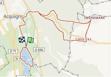
Trail Walking of 13.2 km to be discovered at Normandy, Eure, Acquigny. This trail is proposed by jeanlucien.
Description
Attention pont métallique sur l'Eure barré. Barrières hautes pour personnes agées, d'ou modification du parcours initial 'circuit des etangs)et A/R sur même chemin.
Positioning
Country:
France
Region :
Normandy
Department/Province :
Eure
Municipality :
Acquigny
Location:
Unknown
Start:(Dec)
Start:(UTM)
367728 ; 5446947 (31U) N.
Comments
Trails nearby
![Trail Walking La Haye-le-Comte - La Haye le Comte - Photo](https://media.geolcdn.com/t/375/260/ext.jpg?maxdim=2&url=https%3A%2F%2Fstatic1.geolcdn.com%2Fsiteimages%2Fupload%2Ffiles%2F1553511878bg_sport_marche.png)
![Walking Walking](https://static1.geolcdn.com/sitytour/trail-icons/101.png)
La Haye le Comte
Walking
Medium
(1)
La Haye-le-Comte,
Normandy,
Eure,
France
![](/images/other/stat-length.png)
12 km | 14.7 km-effort
3h 0min
![](https://static1.geolcdn.com/siteimages/upload/files/16400158638029165_repeat_loop_refresh_sync_direction_icon.png)
Yes
![Walking Walking](https://static1.geolcdn.com/sitytour/trail-icons/101.png)
20231012-Amfreville sur Iton
Walking
Medium
(1)
Amfreville-sur-Iton,
Normandy,
Eure,
France
![](/images/other/stat-length.png)
11.6 km | 14.4 km-effort
3h 17min
![](https://static1.geolcdn.com/siteimages/upload/files/16400158638029165_repeat_loop_refresh_sync_direction_icon.png)
Yes
![Trail Road bike Pinterville - Pinterville aller retour - Photo](https://media.geolcdn.com/t/375/260/8eeb09f6-87db-4d49-a311-8b1c5c1f2921.jpg&format=jpg&maxdim=2)
![Road bike Road bike](https://static1.geolcdn.com/sitytour/trail-icons/201.png)
Pinterville aller retour
Road bike
Very easy
Pinterville,
Normandy,
Eure,
France
![](/images/other/stat-length.png)
59 km | 65 km-effort
3h 44min
![](https://static1.geolcdn.com/siteimages/upload/files/16400158638029165_repeat_loop_refresh_sync_direction_icon.png)
Yes
![Trail Walking Amfreville-sur-Iton - rando amfreville sur iton - Photo](https://media.geolcdn.com/t/375/260/1ae1478e-8362-45f5-95df-868478733425.jpg&format=jpg&maxdim=2)
![Walking Walking](https://static1.geolcdn.com/sitytour/trail-icons/101.png)
rando amfreville sur iton
Walking
Medium
Amfreville-sur-Iton,
Normandy,
Eure,
France
![](/images/other/stat-length.png)
12.5 km | 15.4 km-effort
3h 18min
![](https://static1.geolcdn.com/siteimages/upload/files/16400158638029165_repeat_loop_refresh_sync_direction_icon.png)
Yes
![Trail Walking Heudebouville - 20230202-Heudebouville - Photo](https://media.geolcdn.com/t/375/260/9a040f26-251c-4887-9b11-b6efcdf3ee8d.jpg&format=jpg&maxdim=2)
![Walking Walking](https://static1.geolcdn.com/sitytour/trail-icons/101.png)
20230202-Heudebouville
Walking
Medium
Heudebouville,
Normandy,
Eure,
France
![](/images/other/stat-length.png)
12.1 km | 15.1 km-effort
3h 55min
![](https://static1.geolcdn.com/siteimages/upload/files/16400158638029165_repeat_loop_refresh_sync_direction_icon.png)
Yes
![Walking Walking](https://static1.geolcdn.com/sitytour/trail-icons/101.png)
20220628-Heudreville le Jardin de René
Walking
Medium
Heudreville-sur-Eure,
Normandy,
Eure,
France
![](/images/other/stat-length.png)
12 km | 14.1 km-effort
3h 37min
![](https://static1.geolcdn.com/siteimages/upload/files/16400158638029165_repeat_loop_refresh_sync_direction_icon.png)
Yes
![Walking Walking](https://static1.geolcdn.com/sitytour/trail-icons/101.png)
20220129-Amfreville sur Iton
Walking
Medium
Amfreville-sur-Iton,
Normandy,
Eure,
France
![](/images/other/stat-length.png)
11.4 km | 14.2 km-effort
3h 5min
![](https://static1.geolcdn.com/siteimages/upload/files/16400158638029165_repeat_loop_refresh_sync_direction_icon.png)
Yes
![Trail Road bike Acquigny - Acquis y rando vélo - Photo](https://media.geolcdn.com/t/375/260/ef4ceab2-1345-4b6b-a40a-ecfa46ab375d.jpg&format=jpg&maxdim=2)
![Road bike Road bike](https://static1.geolcdn.com/sitytour/trail-icons/201.png)
![Trail Walking Acquigny - Acquigny -Vers le Becdal par la mare Hermier - Photo](https://media.geolcdn.com/t/375/260/ef76d62e-c014-482a-b5da-dbf90d427cbf.jpg&format=jpg&maxdim=2)
![Walking Walking](https://static1.geolcdn.com/sitytour/trail-icons/101.png)
Acquigny -Vers le Becdal par la mare Hermier
Walking
Medium
Acquigny,
Normandy,
Eure,
France
![](/images/other/stat-length.png)
13.3 km | 16 km-effort
3h 41min
![](https://static1.geolcdn.com/siteimages/upload/files/16400158638029165_repeat_loop_refresh_sync_direction_icon.png)
Yes