![](/images/other/stat-length.png)
![Trail Walking Namur - Promenade au départ de l'abbaye de Marche-les-Dames - Photo](https://media.geolcdn.com/t/1900/400/ext.pjpeg?maxdim=2&url=https%3A%2F%2Fstatic1.geolcdn.com%2Fsiteimages%2Fupload%2Ffiles%2F1553511878bg_sport_marche.png)
Promenade au départ de l'abbaye de Marche-les-Dames
loubin54
User
![Length](/images/other/stat-length.png)
Length
5.4 km
![Max alt](https://static1.geolcdn.com/siteimages/upload/files/1508320355ic_sort_altitude_max_24dp.png)
Max alt
203 m
![Uphill gradient](https://static1.geolcdn.com/siteimages/upload/files/1508320355ic_sort_den_pos_24dp.png)
Uphill gradient
186 m
![Km-Effort](/images/other/stat-length.png)
Km-Effort
7.8 km
![Min alt](https://static1.geolcdn.com/siteimages/upload/files/1508320355ic_sort_altitude_min_24dp.png)
Min alt
96 m
![Downhill gradient](https://static1.geolcdn.com/siteimages/upload/files/1508320355ic_sort_den_neg_24dp.png)
Downhill gradient
186 m
![Boucle](https://static1.geolcdn.com/siteimages/upload/files/16400158638029165_repeat_loop_refresh_sync_direction_icon.png)
Boucle
Yes
Creation date :
2020-09-26 12:28:03.038
Updated on :
2020-09-26 12:31:07.951
![Walking](https://static1.geolcdn.com/sitytour/trail-icons/101.png)
1h38
Difficulty : Medium
![Scan this QR Code to open this trail in the SityTrail application](https://capi.geolives.com/qq0zvz2zws4bq2lad0pu/sitytour/trails/2561943/qr.png?size=200)
FREE GPS app for hiking
About
Trail Walking of 5.4 km to be discovered at Wallonia, Namur, Namur. This trail is proposed by loubin54.
Description
Départ du porche, montée vers les pointes des rochers avec vues magnifiques sur la Meuse. Passage au-dessus du rocher où est mort le roi Albert 1ér. Retour vers l'étoile et redescente vers l'abbaye
Positioning
Country:
Belgium
Region :
Wallonia
Department/Province :
Namur
Municipality :
Namur
Location:
Marche-les-Dames
Start:(Dec)
Start:(UTM)
638815 ; 5594732 (31U) N.
Comments
Trails nearby
![Walking Walking](https://static1.geolcdn.com/sitytour/trail-icons/101.png)
RB-Na-26-racc-Sur les chemins du roi Albert 1er
Walking
Difficult
(10)
Fernelmont,
Wallonia,
Namur,
Belgium
![](/images/other/stat-length.png)
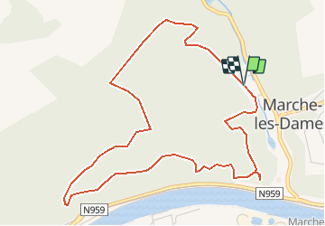
12.9 km | 15.8 km-effort
3h 35min
![](https://static1.geolcdn.com/siteimages/upload/files/16400158638029165_repeat_loop_refresh_sync_direction_icon.png)
Yes
![Walking Walking](https://static1.geolcdn.com/sitytour/trail-icons/101.png)
RB-Na-26_Sur les chemins du roi Albert 1er
Walking
Very difficult
(14)
Fernelmont,
Wallonia,
Namur,
Belgium
![](/images/other/stat-length.png)
21 km | 26 km-effort
5h 59min
![](https://static1.geolcdn.com/siteimages/upload/files/16400158638029165_repeat_loop_refresh_sync_direction_icon.png)
Yes
![Trail Walking Andenne - GESVES- Goyet- n°08- Eau - Photo](https://media.geolcdn.com/t/375/260/ext.jpg?maxdim=2&url=https%3A%2F%2Fservices.sitytrail.com%2FGeolivesWS%2FDownloadMedia.ashx%3FTrailID%3D121402%26Media%3D624555aa-5d04-4964-8666-f3856017c3be.jpg)
![Walking Walking](https://static1.geolcdn.com/sitytour/trail-icons/101.png)
GESVES- Goyet- n°08- Eau
Walking
Difficult
(9)
Andenne,
Wallonia,
Namur,
Belgium
![](/images/other/stat-length.png)
9.1 km | 12.3 km-effort
2h 36min
![](https://static1.geolcdn.com/siteimages/upload/files/16400158638029165_repeat_loop_refresh_sync_direction_icon.png)
Yes
![Trail Walking Andenne - La Vadrouille des Castors - Photo](https://media.geolcdn.com/t/375/260/ext.jpg?maxdim=2&url=https%3A%2F%2Fservices.sitytrail.com%2FGeolivesWS%2FDownloadMedia.ashx%3FTrailID%3D272035%26Media%3D1f2a432f-27e3-4b07-a115-5648fc3f71b1.jpg)
![Walking Walking](https://static1.geolcdn.com/sitytour/trail-icons/101.png)
La Vadrouille des Castors
Walking
Easy
(5)
Andenne,
Wallonia,
Namur,
Belgium
![](/images/other/stat-length.png)
3.6 km | 4.8 km-effort
1h 0min
![](https://static1.geolcdn.com/siteimages/upload/files/16400158638029165_repeat_loop_refresh_sync_direction_icon.png)
Yes
![Trail Walking Gesves - RF-Na-03-Goyet_Grande-boucle - Photo](https://media.geolcdn.com/t/375/260/ext.jpg?maxdim=2&url=https%3A%2F%2Fservices.sitytrail.com%2FGeolivesWS%2FDownloadMedia.ashx%3FTrailID%3D545745%26Media%3D72077e8d-e20a-4ee7-98f3-ad34263963e3.JPG)
![Walking Walking](https://static1.geolcdn.com/sitytour/trail-icons/101.png)
RF-Na-03-Goyet_Grande-boucle
Walking
Medium
(5)
Gesves,
Wallonia,
Namur,
Belgium
![](/images/other/stat-length.png)
6.4 km | 8.9 km-effort
1h 54min
![](https://static1.geolcdn.com/siteimages/upload/files/16400158638029165_repeat_loop_refresh_sync_direction_icon.png)
Yes
![Trail Walking Namur - 2021-10-21_17h46m31_1499 - Photo](https://media.geolcdn.com/t/375/260/aa135fd6-2757-4c70-b0e7-24fa2425e5b7.jpg&format=jpg&maxdim=2)
![Walking Walking](https://static1.geolcdn.com/sitytour/trail-icons/101.png)
2021-10-21_17h46m31_1499
Walking
Difficult
(2)
Namur,
Wallonia,
Namur,
Belgium
![](/images/other/stat-length.png)
14.2 km | 19.5 km-effort
4h 25min
![](https://static1.geolcdn.com/siteimages/upload/files/16400158638029165_repeat_loop_refresh_sync_direction_icon.png)
Yes
![Trail Walking Namur - De Boninne aux Rochers de Marche-les-Dames - Photo](https://media.geolcdn.com/t/375/260/ext.jpg?maxdim=2&url=https%3A%2F%2Fservices.sitytrail.com%2FGeolivesWS%2FDownloadMedia.ashx%3FTrailID%3D1000620%26Media%3D20180707135425.jpg)
![Walking Walking](https://static1.geolcdn.com/sitytour/trail-icons/101.png)
De Boninne aux Rochers de Marche-les-Dames
Walking
Easy
(1)
Namur,
Wallonia,
Namur,
Belgium
![](/images/other/stat-length.png)
10.8 km | 14.6 km-effort
3h 5min
![](https://static1.geolcdn.com/siteimages/upload/files/16400158638029165_repeat_loop_refresh_sync_direction_icon.png)
Yes
![Trail Walking Andenne - Promenade Vezin - Photo](https://media.geolcdn.com/t/375/260/ext.jpg?maxdim=2&url=https%3A%2F%2Fservices.sitytrail.com%2FGeolivesWS%2FDownloadMedia.ashx%3FTrailID%3D272051%26Media%3D7b3740db-ce8a-4aa7-b1b1-8534b8413501.jpg)
![Walking Walking](https://static1.geolcdn.com/sitytour/trail-icons/101.png)
Promenade Vezin
Walking
Easy
(1)
Andenne,
Wallonia,
Namur,
Belgium
![](/images/other/stat-length.png)
6.1 km | 7.8 km-effort
1h 30min
![](https://static1.geolcdn.com/siteimages/upload/files/16400158638029165_repeat_loop_refresh_sync_direction_icon.png)
No
![Trail Walking Andenne - Promenade Thon-Samson - Photo](https://media.geolcdn.com/t/375/260/ext.jpg?maxdim=2&url=https%3A%2F%2Fservices.sitytrail.com%2FGeolivesWS%2FDownloadMedia.ashx%3FTrailID%3D272050%26Media%3Db6cbff1f-3300-45a6-b7c3-0805dc308e5c.jpg)
![Walking Walking](https://static1.geolcdn.com/sitytour/trail-icons/101.png)
Promenade Thon-Samson
Walking
Easy
(2)
Andenne,
Wallonia,
Namur,
Belgium
![](/images/other/stat-length.png)
6.5 km | 8.2 km-effort
1h 30min
![](https://static1.geolcdn.com/siteimages/upload/files/16400158638029165_repeat_loop_refresh_sync_direction_icon.png)
Yes
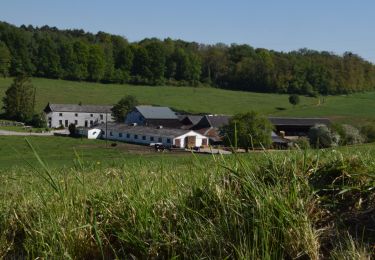
Très belle balade présentant des points de vie magnifiques. La seconde partie de passe en forêt : prévoir des chaussures étanches car les sentiers sont boueux.