Trail On foot Potangis - Potangis à Chantemerle - Photo

Potangis à Chantemerle

© OpenStreetMap contributors
Length
Length
11.4 km
Max alt
Max alt
184 m
Uphill gradient
Uphill gradient
170 m
Km-Effort
Km-Effort  
13.7 km
Min alt
Min alt
77 m
Downhill gradient
Downhill gradient
168 m
Boucle
Boucle
Yes
Creation date :
2020-09-24 21:13:52.157
Updated on :
2020-09-24 21:25:00.079

(1 Reviews)

On foot
On foot
3h00
Difficulty : Medium

Scan this QR Code to open this trail in the SityTrail application

FREE GPS app for hiking

Logo SityTrail SityTrail

IGN / Geographical institutes

Download SityTrail from the App Store Download SityTrail from Google Play

Logo SityTrail SityTrail World

The world is yours!

Download SityTrail from the App Store Download SityTrail from Google Play Download SityTrail on Huawei AppGallery

About

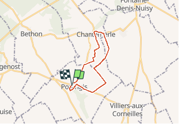
Trail On foot of 11.4 km to be discovered at Grand Est, Marne, Potangis. This trail is proposed by Alain Picard.

Elevation profile

Positioning

Country:
France
Region :
Grand Est
Department/Province :
Marne
Municipality :
Potangis
Location:
Unknown
Start:(UTM)
547423 ; 5381843 (31U) N.

Comments

Please log in to post a review or rate the element


sympa mais les sentiers ne sont pas toujours très praticables.


Trails nearby

Trail Walking Conflans-sur-Seine - ENTRE CONFLANS SUR SEINE ET MARCILLY SUR SEINE - Photo
Walking
jeannine grandjean

Walking

Medium
Conflans-sur-Seine, Grand Est, Marne, France
10.7 km | 11.7 km-effort
2h 39min
Yes
Trail Walking Potangis - Boucle Potangis Le Perre Chantemerle Bethon - Photo
Walking
NANE51

Walking

Easy
Potangis, Grand Est, Marne, France
16.4 km | 19.6 km-effort
3h 33min
Yes
Trail Walking Conflans-sur-Seine - au départ de CONFLANS sur SEINE - Photo
Walking
jeannine grandjean

Walking

Easy
Conflans-sur-Seine, Grand Est, Marne, France
15.7 km | 17.5 km-effort
3h 17min
No
Trail Walking La Celle-sous-Chantemerle - la celle bois de fontaine denis nuisy - Photo
Walking
annisette10

Walking

Difficult
La Celle-sous-Chantemerle, Grand Est, Marne, France
12.5 km | 15.5 km-effort
3h 31min
Yes
Trail Walking Esclavolles-Lurey - Boucle Esclavoles Perigny les éoliennes  - Photo
Walking
NANE51

Walking

Easy
Esclavolles-Lurey, Grand Est, Marne, France
12.6 km | 14.1 km-effort
2h 55min
Yes
Trail Walking Conflans-sur-Seine - Autour de Conflans et Esclavoles - Photo
Walking
NANE51

Walking

Very easy
Conflans-sur-Seine, Grand Est, Marne, France
9.7 km | 10.6 km-effort
1h 53min
Yes
Trail Walking Villiers-aux-Corneilles - Villiers, Chantemerle, Potangis  - Photo
Walking
NANE51

Walking

Easy
(1)
Villiers-aux-Corneilles, Grand Est, Marne, France
12.7 km | 15.2 km-effort
3h 27min
Yes
Trail Walking La Celle-sous-Chantemerle - Boucle la celle vers Chantemerle Bethon - Photo
Walking
NANE51

Walking

La Celle-sous-Chantemerle, Grand Est, Marne, France
12.4 km | 15.2 km-effort
2h 59min
Yes
Trail Walking Marcilly-sur-Seine - Boucle Marcilly / Villers  - Photo
Walking
NANE51

Walking

Marcilly-sur-Seine, Grand Est, Marne, France
13.8 km | 15.7 km-effort
2h 53min
Yes


Close
My subscriptions