Trail Walking Insul - Ahrsteig etappe 3 Rondwandeling 37,5km. - Photo

Ahrsteig etappe 3 Rondwandeling 37,5km.

 flip96
flip96

User

© OpenStreetMap contributors
Length
Length
33 km
Max alt
Max alt
629 m
Uphill gradient
Uphill gradient
1177 m
Km-Effort
Km-Effort  
49 km
Min alt
Min alt
220 m
Downhill gradient
Downhill gradient
1177 m
Boucle
Boucle
Yes
Creation date :
2014-12-10 00:00:00.0
Updated on :
2014-12-10 00:00:00.0

(0 Reviews)

Walking
Walking
11h05
Difficulty : Difficult

Scan this QR Code to open this trail in the SityTrail application

FREE GPS app for hiking

Logo SityTrail SityTrail

IGN / Geographical institutes

Download SityTrail from the App Store Download SityTrail from Google Play

Logo SityTrail SityTrail World

The world is yours!

Download SityTrail from the App Store Download SityTrail from Google Play Download SityTrail on Huawei AppGallery

About

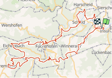
Trail Walking of 33 km to be discovered at Rhineland-Palatinate, Landkreis Ahrweiler, Insul. This trail is proposed by flip96.

Description

Ahrsteig etappe 3 rondwandeling.
Zware, maar zeer mooie route.
Let op! Niet overal paden en een keer moet je de Ahr doorwaden (geen bruggetje).
Zonder GPS niet aan beginnen.
Opmerkingen? flip96@home.nl

Elevation profile

Positioning

Country:
Germany
Region :
Rhineland-Palatinate
Department/Province :
Landkreis Ahrweiler
Municipality :
Insul
Location:
Unknown
Start:(UTM)
351777 ; 5589805 (32U) N.

Trails nearby

Trail On foot Schuld - Schuld Rundweg 6 - Photo
On foot
GUIDE+

On foot

Easy
Schuld, Rhineland-Palatinate, Landkreis Ahrweiler, Germany
3.3 km | 5.3 km-effort
1h 12min
No
Trail On foot Bad Münstereifel - EifelSchleife Rund um Rupperath - Photo
On foot
GUIDE+

On foot

Easy
Bad Münstereifel, North Rhine-Westphalia, Kreis Euskirchen, Germany
7.1 km | 9.5 km-effort
2h 9min
Yes
Trail Walking Hönningen - altenahr4 - Photo
Walking
pvds

Walking

Medium
Hönningen, Rhineland-Palatinate, Landkreis Ahrweiler, Germany
9.9 km | 15.4 km-effort
3h 6min
No


Close
My subscriptions