![](/images/other/stat-length.png)
![Trail Walking Saint-Martin-Vésubie - Lacs Bessons - Photo](https://media.geolcdn.com/t/1900/400/349c98b0-4dc6-495b-a2c1-23c55444c87b.jpeg&format=pjpeg&maxdim=2)
Lacs Bessons
bozo1970
User
![Length](/images/other/stat-length.png)
Length
13.5 km
![Max alt](https://static1.geolcdn.com/siteimages/upload/files/1508320355ic_sort_altitude_max_24dp.png)
Max alt
2644 m
![Uphill gradient](https://static1.geolcdn.com/siteimages/upload/files/1508320355ic_sort_den_pos_24dp.png)
Uphill gradient
1043 m
![Km-Effort](/images/other/stat-length.png)
Km-Effort
27 km
![Min alt](https://static1.geolcdn.com/siteimages/upload/files/1508320355ic_sort_altitude_min_24dp.png)
Min alt
1614 m
![Downhill gradient](https://static1.geolcdn.com/siteimages/upload/files/1508320355ic_sort_den_neg_24dp.png)
Downhill gradient
1045 m
![Boucle](https://static1.geolcdn.com/siteimages/upload/files/16400158638029165_repeat_loop_refresh_sync_direction_icon.png)
Boucle
Yes
Creation date :
2020-09-17 07:06:40.0
Updated on :
2020-09-17 15:30:27.281
![Walking](https://static1.geolcdn.com/sitytour/trail-icons/101.png)
5h14
Difficulty : Medium
![Scan this QR Code to open this trail in the SityTrail application](https://capi.geolives.com/qq0zvz2zws4bq2lad0pu/sitytour/trails/2553649/qr.png?size=200)
FREE GPS app for hiking
About
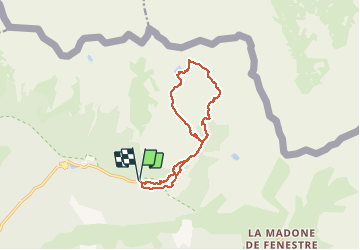
Trail Walking of 13.5 km to be discovered at Provence-Alpes-Côte d'Azur, Maritime Alps, Saint-Martin-Vésubie. This trail is proposed by bozo1970.
Description
Montée par le vallon Sangué
Vallon des lacs Bessons
Collet des lacs
Descente par La Valette Escure et le refuge de Cougourde
Positioning
Country:
France
Region :
Provence-Alpes-Côte d'Azur
Department/Province :
Maritime Alps
Municipality :
Saint-Martin-Vésubie
Location:
Unknown
Start:(Dec)
Start:(UTM)
364548 ; 4885467 (32T) N.
Comments
Trails nearby
![Trail Walking Saint-Martin-Vésubie - Lac de Trécolpas - Photo](https://media.geolcdn.com/t/375/260/ext.jpg?maxdim=2&url=https%3A%2F%2Fservices.sitytrail.com%2FGeolivesWS%2FDownloadMedia.ashx%3FTrailID%3D311062%26Media%3Dfix__20140607150849.jpg)
![Walking Walking](https://static1.geolcdn.com/sitytour/trail-icons/101.png)
Lac de Trécolpas
Walking
Medium
(2)
Saint-Martin-Vésubie,
Provence-Alpes-Côte d'Azur,
Maritime Alps,
France
![](/images/other/stat-length.png)
13.3 km | 20 km-effort
4h 17min
![](https://static1.geolcdn.com/siteimages/upload/files/16400158638029165_repeat_loop_refresh_sync_direction_icon.png)
Yes
![Trail On foot Saint-Martin-Vésubie - SityTrail - Lacs de Prals - Photo](https://media.geolcdn.com/t/375/260/ext.jpg?maxdim=2&url=https%3A%2F%2Fstatic1.geolcdn.com%2Fsiteimages%2Fupload%2Ffiles%2F1545311037marcheuse_200dpi.jpg)
![On foot On foot](https://static1.geolcdn.com/sitytour/trail-icons/100.png)
SityTrail - Lacs de Prals
On foot
Easy
(1)
Saint-Martin-Vésubie,
Provence-Alpes-Côte d'Azur,
Maritime Alps,
France
![](/images/other/stat-length.png)
6.7 km | 13.6 km-effort
3h 5min
![](https://static1.geolcdn.com/siteimages/upload/files/16400158638029165_repeat_loop_refresh_sync_direction_icon.png)
Yes
![Trail Walking Saint-Martin-Vésubie - lacs bessons - Photo](https://media.geolcdn.com/t/375/260/a0e4b44d-1510-4e32-82be-e7e2ee548788.jpg&format=jpg&maxdim=2)
![Walking Walking](https://static1.geolcdn.com/sitytour/trail-icons/101.png)
lacs bessons
Walking
Very easy
(1)
Saint-Martin-Vésubie,
Provence-Alpes-Côte d'Azur,
Maritime Alps,
France
![](/images/other/stat-length.png)
13.1 km | 0 m-effort
7h 36min
![](https://static1.geolcdn.com/siteimages/upload/files/16400158638029165_repeat_loop_refresh_sync_direction_icon.png)
Yes
![Trail Walking Saint-Martin-Vésubie - Lac Ne`gre bis - Photo](https://media.geolcdn.com/t/375/260/ext.jpg?maxdim=2&url=https%3A%2F%2Fservices.sitytrail.com%2FGeolivesWS%2FDownloadMedia.ashx%3FTrailID%3D733947%26Media%3D20170416133857.jpg)
![Walking Walking](https://static1.geolcdn.com/sitytour/trail-icons/101.png)
Lac Ne`gre bis
Walking
Medium
(1)
Saint-Martin-Vésubie,
Provence-Alpes-Côte d'Azur,
Maritime Alps,
France
![](/images/other/stat-length.png)
13.1 km | 23 km-effort
3h 42min
![](https://static1.geolcdn.com/siteimages/upload/files/16400158638029165_repeat_loop_refresh_sync_direction_icon.png)
Yes
![Trail Walking Saint-Martin-Vésubie - Boucle Les lacs de Prals par la cime de la Vallette - Photo](https://media.geolcdn.com/t/375/260/2c298eac-1e8e-4f8d-83e4-c08337da9759.jpg&format=jpg&maxdim=2)
![Walking Walking](https://static1.geolcdn.com/sitytour/trail-icons/101.png)
Boucle Les lacs de Prals par la cime de la Vallette
Walking
Very difficult
Saint-Martin-Vésubie,
Provence-Alpes-Côte d'Azur,
Maritime Alps,
France
![](/images/other/stat-length.png)
13.2 km | 24 km-effort
4h 50min
![](https://static1.geolcdn.com/siteimages/upload/files/16400158638029165_repeat_loop_refresh_sync_direction_icon.png)
Yes
![Trail Walking Saint-Martin-Vésubie - Lac Trecolpas - Pas des Ladres - Col de Fenestre - Refuge Cougourde - Photo](https://media.geolcdn.com/t/375/260/541e5768-e182-4791-be6f-0df4a21d2a23.jpg&format=jpg&maxdim=2)
![Walking Walking](https://static1.geolcdn.com/sitytour/trail-icons/101.png)
Lac Trecolpas - Pas des Ladres - Col de Fenestre - Refuge Cougourde
Walking
Very difficult
Saint-Martin-Vésubie,
Provence-Alpes-Côte d'Azur,
Maritime Alps,
France
![](/images/other/stat-length.png)
15.5 km | 29 km-effort
6h 39min
![](https://static1.geolcdn.com/siteimages/upload/files/16400158638029165_repeat_loop_refresh_sync_direction_icon.png)
Yes
![Trail On foot Saint-Martin-Vésubie - Col de Cerise - Photo](https://media.geolcdn.com/t/375/260/90b1ce11-d155-4ca1-8f15-a1d1ec21efc7.jpeg&format=jpg&maxdim=2)
![On foot On foot](https://static1.geolcdn.com/sitytour/trail-icons/100.png)
Col de Cerise
On foot
Medium
Saint-Martin-Vésubie,
Provence-Alpes-Côte d'Azur,
Maritime Alps,
France
![](/images/other/stat-length.png)
9.7 km | 23 km-effort
5h 18min
![](https://static1.geolcdn.com/siteimages/upload/files/16400158638029165_repeat_loop_refresh_sync_direction_icon.png)
Yes
![Trail On foot Saint-Martin-Vésubie - Circuit de Fenestre - Photo](https://media.geolcdn.com/t/375/260/2f55aaab-545e-409a-9c6e-8c2e9c42d8aa.jpeg&format=jpg&maxdim=2)
![On foot On foot](https://static1.geolcdn.com/sitytour/trail-icons/100.png)
Circuit de Fenestre
On foot
Easy
Saint-Martin-Vésubie,
Provence-Alpes-Côte d'Azur,
Maritime Alps,
France
![](/images/other/stat-length.png)
8.1 km | 16.4 km-effort
3h 44min
![](https://static1.geolcdn.com/siteimages/upload/files/16400158638029165_repeat_loop_refresh_sync_direction_icon.png)
Yes
![Trail On foot Saint-Martin-Vésubie - Circuit de Trécolpas - Photo](https://media.geolcdn.com/t/375/260/f92e70c7-1f9c-4fa6-ae6b-2c614b3b921c.jpeg&format=jpg&maxdim=2)
![On foot On foot](https://static1.geolcdn.com/sitytour/trail-icons/100.png)
Circuit de Trécolpas
On foot
Easy
Saint-Martin-Vésubie,
Provence-Alpes-Côte d'Azur,
Maritime Alps,
France
![](/images/other/stat-length.png)
8.9 km | 15.8 km-effort
3h 35min
![](https://static1.geolcdn.com/siteimages/upload/files/16400158638029165_repeat_loop_refresh_sync_direction_icon.png)
Yes