![](/images/other/stat-length.png)
#200918 - Promenade de la Tour à Corbais
Randos Ouvertes
User
![Length](/images/other/stat-length.png)
Length
8 km
![Max alt](https://static1.geolcdn.com/siteimages/upload/files/1508320355ic_sort_altitude_max_24dp.png)
Max alt
147 m
![Uphill gradient](https://static1.geolcdn.com/siteimages/upload/files/1508320355ic_sort_den_pos_24dp.png)
Uphill gradient
66 m
![Km-Effort](/images/other/stat-length.png)
Km-Effort
8.9 km
![Min alt](https://static1.geolcdn.com/siteimages/upload/files/1508320355ic_sort_altitude_min_24dp.png)
Min alt
121 m
![Downhill gradient](https://static1.geolcdn.com/siteimages/upload/files/1508320355ic_sort_den_neg_24dp.png)
Downhill gradient
66 m
![Boucle](https://static1.geolcdn.com/siteimages/upload/files/16400158638029165_repeat_loop_refresh_sync_direction_icon.png)
Boucle
Yes
Creation date :
2020-09-15 19:22:14.856
Updated on :
2020-09-18 19:54:25.072
![Walking](https://static1.geolcdn.com/sitytour/trail-icons/101.png)
1h58
Difficulty : Medium
![Scan this QR Code to open this trail in the SityTrail application](https://capi.geolives.com/qq0zvz2zws4bq2lad0pu/sitytour/trails/2552167/qr.png?size=200)
FREE GPS app for hiking
About
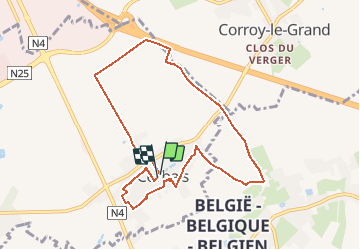
Trail Walking of 8 km to be discovered at Wallonia, Walloon Brabant, Mont-Saint-Guibert. This trail is proposed by Randos Ouvertes.
Description
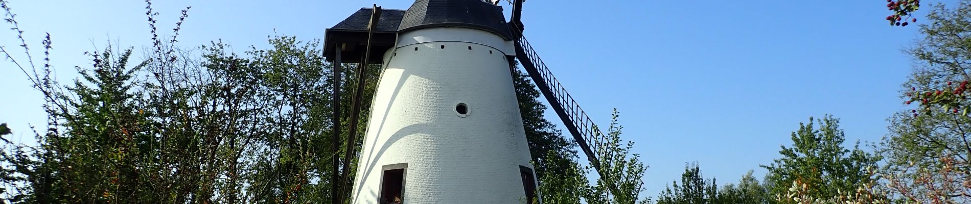
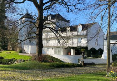
Circuit proposé sur le site de la commune de Mont-Saint-Guibert. Tour des Griffons, moulin du Tiège, fermes Henricot et du Château.
Points of interest
Positioning
Country:
Belgium
Region :
Wallonia
Department/Province :
Walloon Brabant
Municipality :
Mont-Saint-Guibert
Location:
Corbais
Start:(Dec)
Start:(UTM)
617018 ; 5611757 (31U) N.
Comments
Trails nearby
![Trail Walking Ottignies-Louvain-la-Neuve - Nuit du scoutisme - Louvain-la-Neuve - Photo](https://media.geolcdn.com/t/375/260/a66232ef-7471-42b4-b6aa-97b05d528647.jpg&format=jpg&maxdim=2)
![Walking Walking](https://static1.geolcdn.com/sitytour/trail-icons/101.png)
Nuit du scoutisme - Louvain-la-Neuve
Walking
Medium
(16)
Ottignies-Louvain-la-Neuve,
Wallonia,
Walloon Brabant,
Belgium
![](/images/other/stat-length.png)
5.7 km | 6.7 km-effort
1h 27min
![](https://static1.geolcdn.com/siteimages/upload/files/16400158638029165_repeat_loop_refresh_sync_direction_icon.png)
Yes
![Walking Walking](https://static1.geolcdn.com/sitytour/trail-icons/101.png)
SityTrail - #181130 - Autour de Vieusart, version courte
Walking
Medium
(1)
Chaumont-Gistoux,
Wallonia,
Walloon Brabant,
Belgium
![](/images/other/stat-length.png)
7.7 km | 9.3 km-effort
2h 6min
![](https://static1.geolcdn.com/siteimages/upload/files/16400158638029165_repeat_loop_refresh_sync_direction_icon.png)
Yes
![Trail Walking Chaumont-Gistoux - BE-Chaumont-Gistoux - Vieusart - Photo](https://media.geolcdn.com/t/375/260/8d29a104-ec49-41f1-a812-8df11e0d7db1.jpg&format=jpg&maxdim=2)
![Walking Walking](https://static1.geolcdn.com/sitytour/trail-icons/101.png)
BE-Chaumont-Gistoux - Vieusart
Walking
(1)
Chaumont-Gistoux,
Wallonia,
Walloon Brabant,
Belgium
![](/images/other/stat-length.png)
5.6 km | 6.6 km-effort
1h 18min
![](https://static1.geolcdn.com/siteimages/upload/files/16400158638029165_repeat_loop_refresh_sync_direction_icon.png)
Yes
![Trail Walking Mont-Saint-Guibert - Balade à Mont-Saint-Guibert - Photo](https://media.geolcdn.com/t/375/260/ext.jpg?maxdim=2&url=https%3A%2F%2Fservices.sitytrail.com%2FGeolivesWS%2FDownloadMedia.ashx%3FTrailID%3D942864%26Media%3D4a857fe0-cf43-4eb8-b563-62b2b90d4fc2.jpg)
![Walking Walking](https://static1.geolcdn.com/sitytour/trail-icons/101.png)
Balade à Mont-Saint-Guibert
Walking
Very easy
(2)
Mont-Saint-Guibert,
Wallonia,
Walloon Brabant,
Belgium
![](/images/other/stat-length.png)
8.4 km | 10.1 km-effort
2h 12min
![](https://static1.geolcdn.com/siteimages/upload/files/16400158638029165_repeat_loop_refresh_sync_direction_icon.png)
Yes
![Trail Walking Ottignies-Louvain-la-Neuve - Balade dans le Bois de Lauzelle - Photo](https://media.geolcdn.com/t/375/260/ext.jpg?maxdim=2&url=https%3A%2F%2Fservices.sitytrail.com%2FGeolivesWS%2FDownloadMedia.ashx%3FTrailID%3D652718%26Media%3Dfe46824b-6e61-4100-b5d8-1f34a923c154.jpg)
![Walking Walking](https://static1.geolcdn.com/sitytour/trail-icons/101.png)
Balade dans le Bois de Lauzelle
Walking
Very easy
(1)
Ottignies-Louvain-la-Neuve,
Wallonia,
Walloon Brabant,
Belgium
![](/images/other/stat-length.png)
6.3 km | 8.1 km-effort
1h 44min
![](https://static1.geolcdn.com/siteimages/upload/files/16400158638029165_repeat_loop_refresh_sync_direction_icon.png)
Yes
![Walking Walking](https://static1.geolcdn.com/sitytour/trail-icons/101.png)
Lauzelle - Circuit Natura 2000, des sites qui valent le détour ! - Bw01
Walking
Easy
(2)
Ottignies-Louvain-la-Neuve,
Wallonia,
Walloon Brabant,
Belgium
![](/images/other/stat-length.png)
3.8 km | 4.8 km-effort
1h 26min
![](https://static1.geolcdn.com/siteimages/upload/files/16400158638029165_repeat_loop_refresh_sync_direction_icon.png)
Yes
![Walking Walking](https://static1.geolcdn.com/sitytour/trail-icons/101.png)
#240223a - Blanmont, Orne, Alvaux, Nil Pierreux***
Walking
Medium
(1)
Chastre,
Wallonia,
Walloon Brabant,
Belgium
![](/images/other/stat-length.png)
6.6 km | 7.8 km-effort
1h 47min
![](https://static1.geolcdn.com/siteimages/upload/files/16400158638029165_repeat_loop_refresh_sync_direction_icon.png)
Yes
![Walking Walking](https://static1.geolcdn.com/sitytour/trail-icons/101.png)
#240301 - Ocquière
Walking
Medium
(1)
Chaumont-Gistoux,
Wallonia,
Walloon Brabant,
Belgium
![](/images/other/stat-length.png)
5.2 km | 6.2 km-effort
1h 24min
![](https://static1.geolcdn.com/siteimages/upload/files/16400158638029165_repeat_loop_refresh_sync_direction_icon.png)
Yes
![Trail Walking Chaumont-Gistoux - #231016 - Corroy-Le-Grand et le Val d'Ocquière*** (inversé court) - Photo](https://media.geolcdn.com/t/375/260/b650de28-d96e-49f2-85c2-d640aecfc352.jpg&format=jpg&maxdim=2)
![Walking Walking](https://static1.geolcdn.com/sitytour/trail-icons/101.png)
#231016 - Corroy-Le-Grand et le Val d'Ocquière*** (inversé court)
Walking
Medium
(2)
Chaumont-Gistoux,
Wallonia,
Walloon Brabant,
Belgium
![](/images/other/stat-length.png)
6.2 km | 7.2 km-effort
1h 38min
![](https://static1.geolcdn.com/siteimages/upload/files/16400158638029165_repeat_loop_refresh_sync_direction_icon.png)
Yes