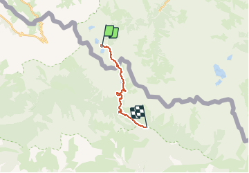
![](/images/other/stat-length.png)
![Trail Walking Valdieri - Refuge Questa- Préfouns-Salèse - Photo](https://media.geolcdn.com/t/1900/400/508302b2-225d-4e63-9424-fa2ed89ce402.jpg&format=pjpeg&maxdim=2)
Refuge Questa- Préfouns-Salèse
ch2slv
User
![Length](/images/other/stat-length.png)
![Max alt](https://static1.geolcdn.com/siteimages/upload/files/1508320355ic_sort_altitude_max_24dp.png)
![Uphill gradient](https://static1.geolcdn.com/siteimages/upload/files/1508320355ic_sort_den_pos_24dp.png)
![Km-Effort](/images/other/stat-length.png)
![Min alt](https://static1.geolcdn.com/siteimages/upload/files/1508320355ic_sort_altitude_min_24dp.png)
![Downhill gradient](https://static1.geolcdn.com/siteimages/upload/files/1508320355ic_sort_den_neg_24dp.png)
![Boucle](https://static1.geolcdn.com/siteimages/upload/files/16400158638029165_repeat_loop_refresh_sync_direction_icon.png)
![Walking](https://static1.geolcdn.com/sitytour/trail-icons/101.png)
4h26
Difficulty : Difficult
![Scan this QR Code to open this trail in the SityTrail application](https://capi.geolives.com/qq0zvz2zws4bq2lad0pu/sitytour/trails/2551746/qr.png?size=200)
FREE GPS app for hiking
About
Trail Walking of 12.9 km to be discovered at Piemont, Cuneo, Valdieri. This trail is proposed by ch2slv.
Description
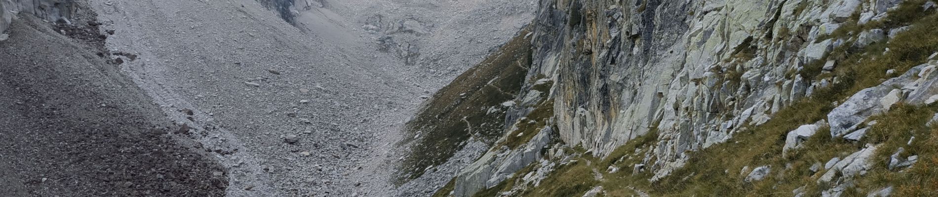
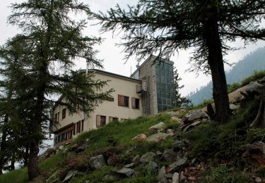
Depuis le refuge en passant par le pas du Préfouns, le lac Nègre jusqu'au parking de Salèse. La montée en Italie du Préfouns est très minérale et encaissée mais toujours très bien tracée. la fin est très pentue et sableuse. le contraste avec la partie française est saisissant. Longue longue descente.
Positioning
Comments
Trails nearby
![Trail Other activity Isola - Isola 2000 baisse Druos refuge Quesa - Photo](https://media.geolcdn.com/t/375/260/ext.jpg?maxdim=2&url=https%3A%2F%2Fservices.sitytrail.com%2FGeolivesWS%2FDownloadMedia.ashx%3FTrailID%3D631831%26Media%3Dfix__20160806152443.jpg)
![Other activity Other activity](https://static1.geolcdn.com/sitytour/trail-icons/900.png)
Other activity
![](/images/other/stat-length.png)
![](https://static1.geolcdn.com/siteimages/upload/files/16400158638029165_repeat_loop_refresh_sync_direction_icon.png)
![Trail On foot Vinadio - Via Alpina Red R141 - Photo](https://media.geolcdn.com/t/375/260/e6824d5d-4c86-4be1-803c-c747aafeef5a.jpeg&format=jpg&maxdim=2)
![On foot On foot](https://static1.geolcdn.com/sitytour/trail-icons/100.png)
![Trail On foot Isola - Tête Mercière - Photo](https://media.geolcdn.com/t/375/260/8e1ca2e5-a446-45a1-b4b9-1747f6caafe0.jpeg&format=jpg&maxdim=2)
![On foot On foot](https://static1.geolcdn.com/sitytour/trail-icons/100.png)
On foot
![](/images/other/stat-length.png)
![](https://static1.geolcdn.com/siteimages/upload/files/16400158638029165_repeat_loop_refresh_sync_direction_icon.png)
![Trail On foot Valdieri - (SI E11) Terme di Valdieri - Rifugio Citta' di Ceva al Malinvern - Photo](https://media.geolcdn.com/t/375/260/dda7d996-3e6c-4f32-87fa-c957c2add5ff.jpeg&format=jpg&maxdim=2)
![On foot On foot](https://static1.geolcdn.com/sitytour/trail-icons/100.png)
On foot
![](/images/other/stat-length.png)
![](https://static1.geolcdn.com/siteimages/upload/files/16400158638029165_repeat_loop_refresh_sync_direction_icon.png)
![Trail On foot Vinadio - (SI E12) Rifugio Citta' di Ceva al Malinvern - Sant'Anna di Vinadio - Photo](https://media.geolcdn.com/t/375/260/e6824d5d-4c86-4be1-803c-c747aafeef5a.jpeg&format=jpg&maxdim=2)
![On foot On foot](https://static1.geolcdn.com/sitytour/trail-icons/100.png)
On foot
![](/images/other/stat-length.png)
![](https://static1.geolcdn.com/siteimages/upload/files/16400158638029165_repeat_loop_refresh_sync_direction_icon.png)
![Trail On foot Valdeblore - Lac Nègre - Photo](https://media.geolcdn.com/t/375/260/523722db-6e8e-40d3-b22f-f8992cf9694d.jpeg&format=jpg&maxdim=2)
![On foot On foot](https://static1.geolcdn.com/sitytour/trail-icons/100.png)
On foot
![](/images/other/stat-length.png)
![](https://static1.geolcdn.com/siteimages/upload/files/16400158638029165_repeat_loop_refresh_sync_direction_icon.png)
![Trail Walking Isola - cime de la lombarde - Photo](https://media.geolcdn.com/t/375/260/ext.jpg?maxdim=2&url=https%3A%2F%2Fstatic1.geolcdn.com%2Fsiteimages%2Fupload%2Ffiles%2F1553511878bg_sport_marche.png)
![Walking Walking](https://static1.geolcdn.com/sitytour/trail-icons/101.png)
Walking
![](/images/other/stat-length.png)
![](https://static1.geolcdn.com/siteimages/upload/files/16400158638029165_repeat_loop_refresh_sync_direction_icon.png)
![Trail sport Isola - Baisse druos - Photo](https://media.geolcdn.com/t/375/260/4a5a3848-1bb0-4b92-8e5a-b87b41fd07ce.jpg&format=jpg&maxdim=2)
sport
![](/images/other/stat-length.png)
![](https://static1.geolcdn.com/siteimages/upload/files/16400158638029165_repeat_loop_refresh_sync_direction_icon.png)
![Trail Snowshoes Isola - Cime de Tavels - Photo](https://media.geolcdn.com/t/375/260/47b87ec6-cb26-4b85-87fc-e2f750781dc5.jpg&format=jpg&maxdim=2)
![Snowshoes Snowshoes](https://static1.geolcdn.com/sitytour/trail-icons/504.png)
Snowshoes
![](/images/other/stat-length.png)
![](https://static1.geolcdn.com/siteimages/upload/files/16400158638029165_repeat_loop_refresh_sync_direction_icon.png)