Trail Walking Gresse-en-Vercors - Vercors jour 3: Pas des Bachassons à  - Photo

Vercors jour 3: Pas des Bachassons à

© OpenStreetMap contributors
Length
Length
19.7 km
Max alt
Max alt
1881 m
Uphill gradient
Uphill gradient
333 m
Km-Effort
Km-Effort  
26 km
Min alt
Min alt
1309 m
Downhill gradient
Downhill gradient
811 m
Boucle
Boucle
No
Creation date :
2020-09-15 09:55:45.726
Updated on :
2020-09-15 10:46:22.657

(0 Reviews)

Walking
Walking
6m
Difficulty : Easy

Scan this QR Code to open this trail in the SityTrail application

FREE GPS app for hiking

Logo SityTrail SityTrail

IGN / Geographical institutes

Download SityTrail from the App Store Download SityTrail from Google Play

Logo SityTrail SityTrail World

The world is yours!

Download SityTrail from the App Store Download SityTrail from Google Play Download SityTrail on Huawei AppGallery

About

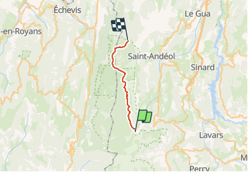
Trail Walking of 19.7 km to be discovered at Auvergne-Rhône-Alpes, Isère, Gresse-en-Vercors. This trail is proposed by MathieuBourgois.

Description

Pas des Bachassons: 500m et 0D
Fontaine de Chau 5km et 30D
Refuge Jasse du Play 7.6km et 80D
Puit de Darbounouse
Cabane de Carette: 20km et 333D

Elevation profile

Positioning

Country:
France
Region :
Auvergne-Rhône-Alpes
Department/Province :
Isère
Municipality :
Gresse-en-Vercors
Location:
Unknown
Start:(UTM)
699140 ; 4969780 (31T) N.

Trails nearby

Trail Walking Saint-Michel-les-Portes - Grand Ceymont par la face Sud - Photo
Walking
GUIDE
nadd73

Walking

Difficult
(1)
Saint-Michel-les-Portes, Auvergne-Rhône-Alpes, Isère, France
14.3 km | 31 km-effort
6h 0min
Yes
Trail Walking Gresse-en-Vercors - Quinquambaye - crête du Brisou - Photo
Walking
patjobou

Walking

Medium
(1)
Gresse-en-Vercors, Auvergne-Rhône-Alpes, Isère, France
12.1 km | 23 km-effort
6h 28min
Yes
Trail Walking Gresse-en-Vercors - Traversée du Rocher du Baconnet - Photo
Walking
tracegps

Walking

Easy
(2)
Gresse-en-Vercors, Auvergne-Rhône-Alpes, Isère, France
10.7 km | 18.9 km-effort
5h 0min
Yes
Trail Walking Chichilianne - La Fontaine Pourrie - Hauts Plateaux Sud du Vercors - Photo
Walking
tracegps

Walking

Medium
(2)
Chichilianne, Auvergne-Rhône-Alpes, Isère, France
19.4 km | 33 km-effort
7h 45min
Yes
Trail Walking Gresse-en-Vercors - traversée Sud nord du Grand Veymont  - Photo
Walking
GUIDE
nadd73

Walking

Difficult
Gresse-en-Vercors, Auvergne-Rhône-Alpes, Isère, France
26 km | 40 km-effort
10h 42min
No
Trail Walking Chichilianne - 14923554-Tour du Mont Aiguille - Photo
Walking
Maryma

Walking

Very difficult
(1)
Chichilianne, Auvergne-Rhône-Alpes, Isère, France
17.7 km | 33 km-effort
7h 27min
Yes
Trail Walking Gresse-en-Vercors - le grand veymont  depuis gresse en vercors et par le pas de la ville - Photo
Walking
aztec

Walking

Medium
(1)
Gresse-en-Vercors, Auvergne-Rhône-Alpes, Isère, France
10.9 km | 25 km-effort
4h 53min
Yes
Trail Snowshoes Chichilianne - chichilianne archiane - Photo
Snowshoes
jerome-dupont@laposte.net

Snowshoes

Medium
(1)
Chichilianne, Auvergne-Rhône-Alpes, Isère, France
18.9 km | 32 km-effort
8h 0min
No
Trail Walking Chichilianne - Diois 2024 1ère journée  - Photo
Walking
planets

Walking

Medium
Chichilianne, Auvergne-Rhône-Alpes, Isère, France
22 km | 35 km-effort
4h 59min
No


Close
My subscriptions