![](/images/other/stat-length.png)
![Trail Walking Prats-de-Mollo-la-Preste - Le Chalet -La Forge -Col Pregon -Col de Siern - Le Chalet . - Photo](https://media.geolcdn.com/t/1900/400/3225b7ee-f250-49e8-b7c0-938203cb4be0.jpg&format=pjpeg&maxdim=2)
Le Chalet -La Forge -Col Pregon -Col de Siern - Le Chalet .
dede83
User
![Length](/images/other/stat-length.png)
Length
11.8 km
![Max alt](https://static1.geolcdn.com/siteimages/upload/files/1508320355ic_sort_altitude_max_24dp.png)
Max alt
1661 m
![Uphill gradient](https://static1.geolcdn.com/siteimages/upload/files/1508320355ic_sort_den_pos_24dp.png)
Uphill gradient
662 m
![Km-Effort](/images/other/stat-length.png)
Km-Effort
21 km
![Min alt](https://static1.geolcdn.com/siteimages/upload/files/1508320355ic_sort_altitude_min_24dp.png)
Min alt
1049 m
![Downhill gradient](https://static1.geolcdn.com/siteimages/upload/files/1508320355ic_sort_den_neg_24dp.png)
Downhill gradient
660 m
![Boucle](https://static1.geolcdn.com/siteimages/upload/files/16400158638029165_repeat_loop_refresh_sync_direction_icon.png)
Boucle
Yes
Creation date :
2020-09-14 10:54:21.409
Updated on :
2020-09-14 15:08:05.961
![Walking](https://static1.geolcdn.com/sitytour/trail-icons/101.png)
4h12
Difficulty : Medium
![Scan this QR Code to open this trail in the SityTrail application](https://capi.geolives.com/qq0zvz2zws4bq2lad0pu/sitytour/trails/2550856/qr.png?size=200)
FREE GPS app for hiking
About
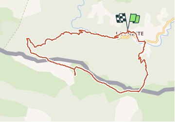
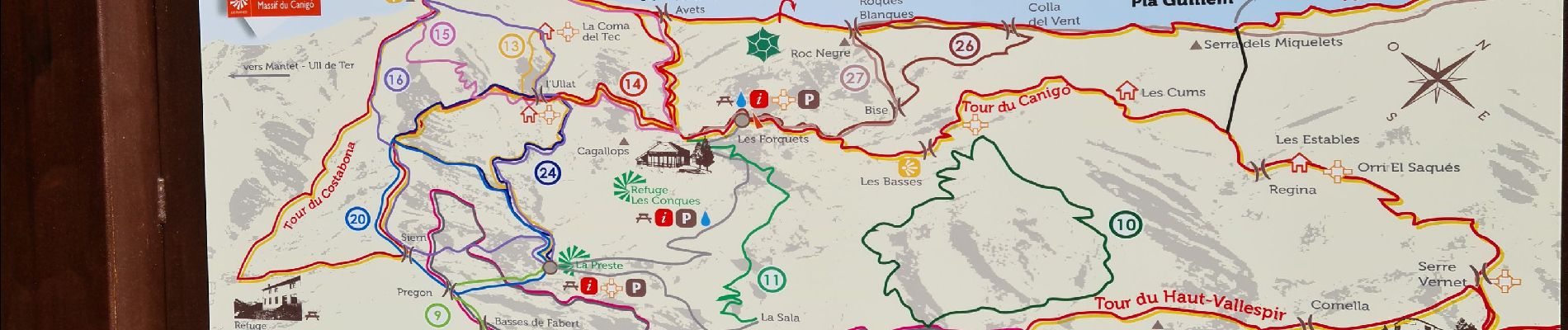
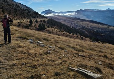
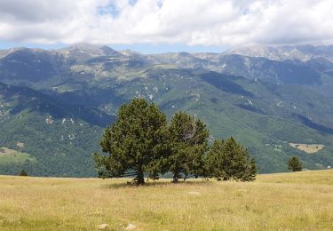
Trail Walking of 11.8 km to be discovered at Occitania, Pyrénées-Orientales, Prats-de-Mollo-la-Preste. This trail is proposed by dede83.
Description
Très belle balade avec une montée au col Pregon un peu raide . Du col Pregon au col de Siern le balisage est un peu juste. Sinon c'est une très belle promenade .
Positioning
Country:
France
Region :
Occitania
Department/Province :
Pyrénées-Orientales
Municipality :
Prats-de-Mollo-la-Preste
Location:
Unknown
Start:(Dec)
Start:(UTM)
450945 ; 4695354 (31T) N.
Comments
Trails nearby
![Trail Walking Prats-de-Mollo-la-Preste - Pic de Costabonne par les Conques_T - Photo](https://media.geolcdn.com/t/375/260/ext.jpg?maxdim=2&url=https%3A%2F%2Fservices.sitytrail.com%2FGeolivesWS%2FDownloadMedia.ashx%3FTrailID%3D209493%26Media%3Dfix__20130801075840.jpg)
![Walking Walking](https://static1.geolcdn.com/sitytour/trail-icons/101.png)
Pic de Costabonne par les Conques_T
Walking
Medium
(1)
Prats-de-Mollo-la-Preste,
Occitania,
Pyrénées-Orientales,
France
![](/images/other/stat-length.png)
20 km | 36 km-effort
7h 56min
![](https://static1.geolcdn.com/siteimages/upload/files/16400158638029165_repeat_loop_refresh_sync_direction_icon.png)
Yes
![Trail Walking Prats-de-Mollo-la-Preste - Forquet col del vents pic set homme roche blanche retour forquey - Photo](https://media.geolcdn.com/t/375/260/7bbcf549-e385-4d58-8318-7192b6fb54e4.jpg&format=jpg&maxdim=2)
![Walking Walking](https://static1.geolcdn.com/sitytour/trail-icons/101.png)
Forquet col del vents pic set homme roche blanche retour forquey
Walking
Difficult
Prats-de-Mollo-la-Preste,
Occitania,
Pyrénées-Orientales,
France
![](/images/other/stat-length.png)
22 km | 38 km-effort
9h 59min
![](https://static1.geolcdn.com/siteimages/upload/files/16400158638029165_repeat_loop_refresh_sync_direction_icon.png)
Yes
![Trail Walking Prats-de-Mollo-la-Preste - Fourquettes Collada del vent Roches banches retour - Photo](https://media.geolcdn.com/t/375/260/027c601f-0810-42dd-bd2d-23c81e3b9425.jpg&format=jpg&maxdim=2)
![Walking Walking](https://static1.geolcdn.com/sitytour/trail-icons/101.png)
Fourquettes Collada del vent Roches banches retour
Walking
Medium
Prats-de-Mollo-la-Preste,
Occitania,
Pyrénées-Orientales,
France
![](/images/other/stat-length.png)
13.4 km | 23 km-effort
5h 13min
![](https://static1.geolcdn.com/siteimages/upload/files/16400158638029165_repeat_loop_refresh_sync_direction_icon.png)
Yes
![Trail Walking Prats-de-Mollo-la-Preste - Costabone via Siern Esquerdes de roja Rocarodona La Preste - Photo](https://media.geolcdn.com/t/375/260/5a9b2aaa-e81c-4ab0-ba2f-ee276fb16f06.jpg&format=jpg&maxdim=2)
![Walking Walking](https://static1.geolcdn.com/sitytour/trail-icons/101.png)
Costabone via Siern Esquerdes de roja Rocarodona La Preste
Walking
Difficult
Prats-de-Mollo-la-Preste,
Occitania,
Pyrénées-Orientales,
France
![](/images/other/stat-length.png)
22 km | 41 km-effort
10h 53min
![](https://static1.geolcdn.com/siteimages/upload/files/16400158638029165_repeat_loop_refresh_sync_direction_icon.png)
Yes
![Trail Walking Prats-de-Mollo-la-Preste - La Preste - Col de Siern - Photo](https://media.geolcdn.com/t/375/260/7a1662cf-910c-4c82-998e-a66ceefc68dc.jpg&format=jpg&maxdim=2)
![Walking Walking](https://static1.geolcdn.com/sitytour/trail-icons/101.png)
La Preste - Col de Siern
Walking
Very easy
Prats-de-Mollo-la-Preste,
Occitania,
Pyrénées-Orientales,
France
![](/images/other/stat-length.png)
9.7 km | 17 km-effort
3h 16min
![](https://static1.geolcdn.com/siteimages/upload/files/16400158638029165_repeat_loop_refresh_sync_direction_icon.png)
No
![Trail Walking Prats-de-Mollo-la-Preste - Les Conques sources du Tech_T - Photo](https://media.geolcdn.com/t/375/260/3201f24d-1bdf-4698-a9ae-280abac4a73f.jpg&format=jpg&maxdim=2)
![Walking Walking](https://static1.geolcdn.com/sitytour/trail-icons/101.png)
Les Conques sources du Tech_T
Walking
Medium
Prats-de-Mollo-la-Preste,
Occitania,
Pyrénées-Orientales,
France
![](/images/other/stat-length.png)
18.1 km | 31 km-effort
7h 17min
![](https://static1.geolcdn.com/siteimages/upload/files/16400158638029165_repeat_loop_refresh_sync_direction_icon.png)
Yes
![Trail Walking Prats-de-Mollo-la-Preste - Siern Pregon Tours de Mir_T - Photo](https://media.geolcdn.com/t/375/260/5ce8bc86-2789-489e-a485-8f5861c03fc4.jpg&format=jpg&maxdim=2)
![Walking Walking](https://static1.geolcdn.com/sitytour/trail-icons/101.png)
Siern Pregon Tours de Mir_T
Walking
Difficult
Prats-de-Mollo-la-Preste,
Occitania,
Pyrénées-Orientales,
France
![](/images/other/stat-length.png)
17.5 km | 29 km-effort
3h 35min
![](https://static1.geolcdn.com/siteimages/upload/files/16400158638029165_repeat_loop_refresh_sync_direction_icon.png)
Yes
![Trail Walking Molló - Tour de Mir (20/9/2018) - Photo](https://media.geolcdn.com/t/375/260/ef1914cd-274d-423f-8146-4fa054ce416c.jpg&format=jpg&maxdim=2)
![Walking Walking](https://static1.geolcdn.com/sitytour/trail-icons/101.png)
Tour de Mir (20/9/2018)
Walking
Easy
Molló,
Catalonia,
Girona,
Spain
![](/images/other/stat-length.png)
11.6 km | 15.4 km-effort
3h 46min
![](https://static1.geolcdn.com/siteimages/upload/files/16400158638029165_repeat_loop_refresh_sync_direction_icon.png)
Yes
![Trail Walking Py - Mantet refuge Da Silva via la Porteille de Rotja Cime de P0marole - Photo](https://media.geolcdn.com/t/375/260/ext.jpg?maxdim=2&url=https%3A%2F%2Fservices.sitytrail.com%2FGeolivesWS%2FDownloadMedia.ashx%3FTrailID%3D995622%26Media%3Dfix__20180627082611.jpg)
![Walking Walking](https://static1.geolcdn.com/sitytour/trail-icons/101.png)
Mantet refuge Da Silva via la Porteille de Rotja Cime de P0marole
Walking
Medium
Py,
Occitania,
Pyrénées-Orientales,
France
![](/images/other/stat-length.png)
10 km | 17.7 km-effort
5h 34min
![](https://static1.geolcdn.com/siteimages/upload/files/16400158638029165_repeat_loop_refresh_sync_direction_icon.png)
Yes
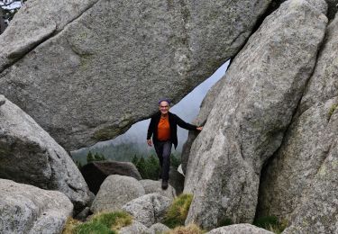
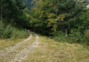
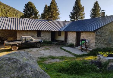
jolie rando en partie ombragée. le départ est erroné. se garer au parking de la preste.marcher en traversant la preste jusqu au croisement route menant au refuge des conques,juste au dessous de l intersection, le petit chemin menant au col perron demarre