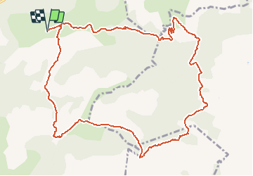
![](/images/other/stat-length.png)
![Trail Walking Saint-Maurice-Navacelles - survol de la Buèges et de la Vis - Photo](https://media.geolcdn.com/t/1900/400/ext.pjpeg?maxdim=2&url=https%3A%2F%2Fstatic1.geolcdn.com%2Fsiteimages%2Fupload%2Ffiles%2F1553511878bg_sport_marche.png)
survol de la Buèges et de la Vis
genevieve
User
![Length](/images/other/stat-length.png)
![Max alt](https://static1.geolcdn.com/siteimages/upload/files/1508320355ic_sort_altitude_max_24dp.png)
![Uphill gradient](https://static1.geolcdn.com/siteimages/upload/files/1508320355ic_sort_den_pos_24dp.png)
![Km-Effort](/images/other/stat-length.png)
![Min alt](https://static1.geolcdn.com/siteimages/upload/files/1508320355ic_sort_altitude_min_24dp.png)
![Downhill gradient](https://static1.geolcdn.com/siteimages/upload/files/1508320355ic_sort_den_neg_24dp.png)
![Boucle](https://static1.geolcdn.com/siteimages/upload/files/16400158638029165_repeat_loop_refresh_sync_direction_icon.png)
![Walking](https://static1.geolcdn.com/sitytour/trail-icons/101.png)
4h20
Difficulty : Medium
![Scan this QR Code to open this trail in the SityTrail application](https://capi.geolives.com/qq0zvz2zws4bq2lad0pu/sitytour/trails/254841/qr.png?size=200)
FREE GPS app for hiking
About
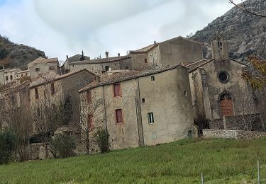
Trail Walking of 13.4 km to be discovered at Occitania, Hérault, Saint-Maurice-Navacelles. This trail is proposed by genevieve.
Description
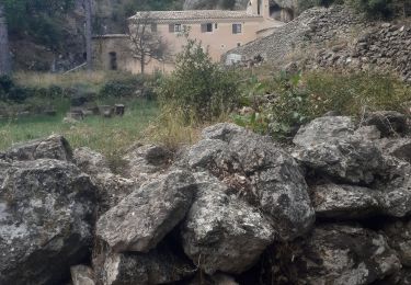
Départ avant le Ranquet
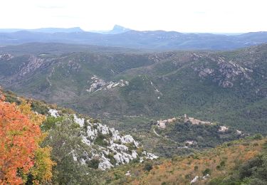
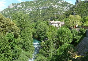
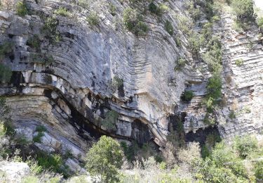
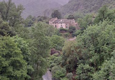
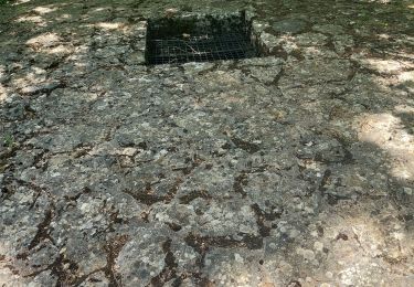
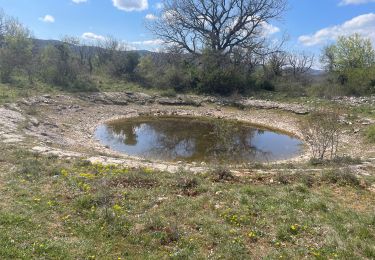
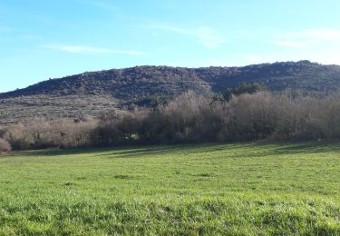
randonnée assez accessible avec de belles vue sur la vallée de la Buège et les gorges de la Vis. Panorama très beau et vue à 360°, après Peyre Martine sentier balisé en bleu mais attention Lapiaz, bien regarder où on pose le pied et s'arrêter pour admirer le paysage.
Positioning
Comments
Trails nearby
![Trail Walking Pégairolles-de-Buèges - Seranne Pontel - Photo](https://media.geolcdn.com/t/375/260/29a3d2a0-e263-4feb-8b8a-8f793f3452c4.jpg&format=jpg&maxdim=2)
![Walking Walking](https://static1.geolcdn.com/sitytour/trail-icons/101.png)
Walking
![](/images/other/stat-length.png)
![](https://static1.geolcdn.com/siteimages/upload/files/16400158638029165_repeat_loop_refresh_sync_direction_icon.png)
![Trail Walking Rogues - Madières - La Sauvie - Photo](https://media.geolcdn.com/t/375/260/ext.jpg?maxdim=2&url=https%3A%2F%2Fservices.sitytrail.com%2FGeolivesWS%2FDownloadMedia.ashx%3FTrailID%3D214916%26Media%3D15483_6.jpg)
![Walking Walking](https://static1.geolcdn.com/sitytour/trail-icons/101.png)
Walking
![](/images/other/stat-length.png)
![](https://static1.geolcdn.com/siteimages/upload/files/16400158638029165_repeat_loop_refresh_sync_direction_icon.png)
![Trail Walking Saint-Maurice-Navacelles - Cirque de Navacelles Causses et Gorges de la Vis - Photo](https://media.geolcdn.com/t/375/260/dae2c70d-6c56-4f7c-a199-7ae450c239f7.jpg&format=jpg&maxdim=2)
![Walking Walking](https://static1.geolcdn.com/sitytour/trail-icons/101.png)
Walking
![](/images/other/stat-length.png)
![](https://static1.geolcdn.com/siteimages/upload/files/16400158638029165_repeat_loop_refresh_sync_direction_icon.png)
![Trail Walking Rogues - Vallée de la Vis - Photo](https://media.geolcdn.com/t/375/260/bce43fc6-f68f-4db4-9e30-b90af5d82bd2.jpg&format=jpg&maxdim=2)
![Walking Walking](https://static1.geolcdn.com/sitytour/trail-icons/101.png)
![Trail Walking Saint-Maurice-Navacelles - St-Maurice, les Rajols - Photo](https://media.geolcdn.com/t/375/260/e3ad78ed-e075-42bc-a10e-4ccf0ec188cc.jpg&format=jpg&maxdim=2)
![Walking Walking](https://static1.geolcdn.com/sitytour/trail-icons/101.png)
Walking
![](/images/other/stat-length.png)
![](https://static1.geolcdn.com/siteimages/upload/files/16400158638029165_repeat_loop_refresh_sync_direction_icon.png)
![Trail Walking Saint-Maurice-Navacelles - saint Maurice de navacelles - Photo](https://media.geolcdn.com/t/375/260/dbff70b4-0e63-4f5d-9646-57dd5ac329b7.jpg&format=jpg&maxdim=2)
![Walking Walking](https://static1.geolcdn.com/sitytour/trail-icons/101.png)
Walking
![](/images/other/stat-length.png)
![](https://static1.geolcdn.com/siteimages/upload/files/16400158638029165_repeat_loop_refresh_sync_direction_icon.png)
![Trail Walking Saint-Maurice-Navacelles - Les Rajols - Photo](https://media.geolcdn.com/t/375/260/c6418992-3cd9-44bc-8b2b-711b66e4b79a.jpg&format=jpg&maxdim=2)
![Walking Walking](https://static1.geolcdn.com/sitytour/trail-icons/101.png)
Walking
![](/images/other/stat-length.png)
![](https://static1.geolcdn.com/siteimages/upload/files/16400158638029165_repeat_loop_refresh_sync_direction_icon.png)
![Trail Walking Saint-Maurice-Navacelles - Cirque de Navacelle - Photo](https://media.geolcdn.com/t/375/260/c5741995-0d4a-4365-8e1b-8e43174168b2.jpg&format=jpg&maxdim=2)
![Walking Walking](https://static1.geolcdn.com/sitytour/trail-icons/101.png)
Walking
![](/images/other/stat-length.png)
![](https://static1.geolcdn.com/siteimages/upload/files/16400158638029165_repeat_loop_refresh_sync_direction_icon.png)
![Trail Walking Saint-Maurice-Navacelles - Le randas st guilhem le désert - Photo](https://media.geolcdn.com/t/375/260/c28eb3f5-891a-43c6-8524-036e3d9b9a06.jpg&format=jpg&maxdim=2)
![Walking Walking](https://static1.geolcdn.com/sitytour/trail-icons/101.png)
Walking
![](/images/other/stat-length.png)
![](https://static1.geolcdn.com/siteimages/upload/files/16400158638029165_repeat_loop_refresh_sync_direction_icon.png)