![](/images/other/stat-length.png)
![Trail Walking Beaufort - st gyerin. Grand mont. lacs de la tempête - Photo](https://media.geolcdn.com/t/1900/400/78bc4139-f31e-43e6-a3fd-b1c8aa2e54c1.jpg&format=pjpeg&maxdim=2)
st gyerin. Grand mont. lacs de la tempête
olivecoco
User
![Length](/images/other/stat-length.png)
Length
15.8 km
![Max alt](https://static1.geolcdn.com/siteimages/upload/files/1508320355ic_sort_altitude_max_24dp.png)
Max alt
2670 m
![Uphill gradient](https://static1.geolcdn.com/siteimages/upload/files/1508320355ic_sort_den_pos_24dp.png)
Uphill gradient
1351 m
![Km-Effort](/images/other/stat-length.png)
Km-Effort
34 km
![Min alt](https://static1.geolcdn.com/siteimages/upload/files/1508320355ic_sort_altitude_min_24dp.png)
Min alt
1509 m
![Downhill gradient](https://static1.geolcdn.com/siteimages/upload/files/1508320355ic_sort_den_neg_24dp.png)
Downhill gradient
1354 m
![Boucle](https://static1.geolcdn.com/siteimages/upload/files/16400158638029165_repeat_loop_refresh_sync_direction_icon.png)
Boucle
Yes
Creation date :
2020-09-08 08:01:44.92
Updated on :
2020-09-11 10:54:49.613
![Walking](https://static1.geolcdn.com/sitytour/trail-icons/101.png)
7h14
Difficulty : Medium
![Scan this QR Code to open this trail in the SityTrail application](https://capi.geolives.com/qq0zvz2zws4bq2lad0pu/sitytour/trails/2546562/qr.png?size=200)
FREE GPS app for hiking
About
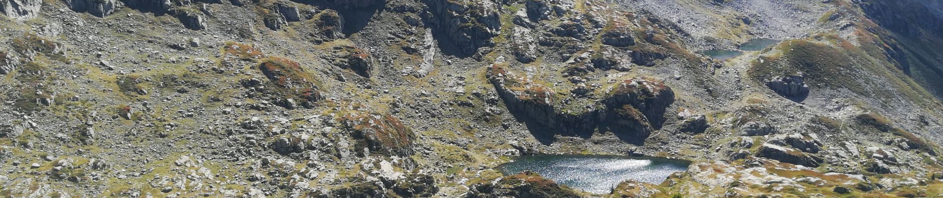
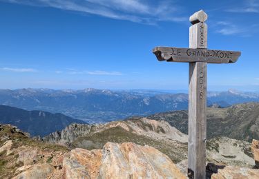
Trail Walking of 15.8 km to be discovered at Auvergne-Rhône-Alpes, Savoy, Beaufort. This trail is proposed by olivecoco.
Description
Très jolie boucle, variée avec panorama à 360 incroyable au grand mont et descente sur ces perles que sont les lacs de la tempête
Positioning
Country:
France
Region :
Auvergne-Rhône-Alpes
Department/Province :
Savoy
Municipality :
Beaufort
Location:
Unknown
Start:(Dec)
Start:(UTM)
311662 ; 5058115 (32T) N.
Comments
Trails nearby
![Trail Walking Beaufort - D'Arêches au Col de Pré par le hameau de Boudin - Photo](https://media.geolcdn.com/t/375/260/ext.jpg?maxdim=2&url=https%3A%2F%2Fservices.sitytrail.com%2FGeolivesWS%2FDownloadMedia.ashx%3FTrailID%3D112688%26Media%3D11533_5.jpg)
![Walking Walking](https://static1.geolcdn.com/sitytour/trail-icons/101.png)
D'Arêches au Col de Pré par le hameau de Boudin
Walking
Medium
(1)
Beaufort,
Auvergne-Rhône-Alpes,
Savoy,
France
![](/images/other/stat-length.png)
8.2 km | 17.9 km-effort
4h 0min
![](https://static1.geolcdn.com/siteimages/upload/files/16400158638029165_repeat_loop_refresh_sync_direction_icon.png)
Yes
![Trail Walking Beaufort - Arêches Cuvy - Photo](https://media.geolcdn.com/t/375/260/ext.jpg?maxdim=2&url=https%3A%2F%2Fstatic1.geolcdn.com%2Fsiteimages%2Fupload%2Ffiles%2F1553511878bg_sport_marche.png)
![Walking Walking](https://static1.geolcdn.com/sitytour/trail-icons/101.png)
Arêches Cuvy
Walking
Medium
(1)
Beaufort,
Auvergne-Rhône-Alpes,
Savoy,
France
![](/images/other/stat-length.png)
7.1 km | 13.9 km-effort
2h 36min
![](https://static1.geolcdn.com/siteimages/upload/files/16400158638029165_repeat_loop_refresh_sync_direction_icon.png)
No
![Trail Walking Aime-la-Plagne - 2024-09-08 Marche Tour Beaufortain Refuge Coire vers Refuge Presset - Photo](https://media.geolcdn.com/t/375/260/b0c8e42e-e06a-4d0e-aaaf-41f5a8616494.jpg&format=jpg&maxdim=2)
![Walking Walking](https://static1.geolcdn.com/sitytour/trail-icons/101.png)
2024-09-08 Marche Tour Beaufortain Refuge Coire vers Refuge Presset
Walking
Very difficult
Aime-la-Plagne,
Auvergne-Rhône-Alpes,
Savoy,
France
![](/images/other/stat-length.png)
13.6 km | 26 km-effort
5h 48min
![](https://static1.geolcdn.com/siteimages/upload/files/16400158638029165_repeat_loop_refresh_sync_direction_icon.png)
No
![Trail Walking Beaufort - suuntoapp-Hiking-2024-09-07T06-03-31Z - Photo](https://media.geolcdn.com/t/375/260/1c7a5e77-787c-4d14-8dd4-f96128769e9c.jpg&format=jpg&maxdim=2)
![Walking Walking](https://static1.geolcdn.com/sitytour/trail-icons/101.png)
suuntoapp-Hiking-2024-09-07T06-03-31Z
Walking
Very difficult
Beaufort,
Auvergne-Rhône-Alpes,
Savoy,
France
![](/images/other/stat-length.png)
21 km | 38 km-effort
8h 42min
![](https://static1.geolcdn.com/siteimages/upload/files/16400158638029165_repeat_loop_refresh_sync_direction_icon.png)
No
![Trail Touring skiing Beaufort - Anticime de la pointe de la grande journée, montée couloir du grepets - Photo](https://media.geolcdn.com/t/375/260/8dfd1937-3bd4-42bd-a4fa-284d4bb8802e.jpg&format=jpg&maxdim=2)
![Touring skiing Touring skiing](https://static1.geolcdn.com/sitytour/trail-icons/503.png)
Anticime de la pointe de la grande journée, montée couloir du grepets
Touring skiing
Difficult
Beaufort,
Auvergne-Rhône-Alpes,
Savoy,
France
![](/images/other/stat-length.png)
13.4 km | 30 km-effort
4h 48min
![](https://static1.geolcdn.com/siteimages/upload/files/16400158638029165_repeat_loop_refresh_sync_direction_icon.png)
Yes
![Trail Touring skiing Beaufort - Côte 2000 et col de Roche plane - Photo](https://media.geolcdn.com/t/375/260/38a11e49-5450-4382-89d2-44ae6ea43162.jpg&format=jpg&maxdim=2)
![Touring skiing Touring skiing](https://static1.geolcdn.com/sitytour/trail-icons/503.png)
Côte 2000 et col de Roche plane
Touring skiing
Easy
Beaufort,
Auvergne-Rhône-Alpes,
Savoy,
France
![](/images/other/stat-length.png)
12.5 km | 29 km-effort
6h 46min
![](https://static1.geolcdn.com/siteimages/upload/files/16400158638029165_repeat_loop_refresh_sync_direction_icon.png)
Yes
![Trail Walking Beaufort - lac de Presset et passeur de la Mintaz (belvédère de la Pierra Menta) - Photo](https://media.geolcdn.com/t/375/260/0e1a7432-483a-440c-958e-0a3e3d697f7b.jpg&format=jpg&maxdim=2)
![Walking Walking](https://static1.geolcdn.com/sitytour/trail-icons/101.png)
lac de Presset et passeur de la Mintaz (belvédère de la Pierra Menta)
Walking
Difficult
Beaufort,
Auvergne-Rhône-Alpes,
Savoy,
France
![](/images/other/stat-length.png)
11.6 km | 24 km-effort
2h 57min
![](https://static1.geolcdn.com/siteimages/upload/files/16400158638029165_repeat_loop_refresh_sync_direction_icon.png)
Yes
![Trail Walking Beaufort - Lac d’Amour - col du Coin 10 km -680 m dénivelé + - Photo](https://media.geolcdn.com/t/375/260/3b47f1f6-ac20-42ea-91ad-660067538617.jpg&format=jpg&maxdim=2)
![Walking Walking](https://static1.geolcdn.com/sitytour/trail-icons/101.png)
Lac d’Amour - col du Coin 10 km -680 m dénivelé +
Walking
Medium
Beaufort,
Auvergne-Rhône-Alpes,
Savoy,
France
![](/images/other/stat-length.png)
10.4 km | 19.6 km-effort
7h 5min
![](https://static1.geolcdn.com/siteimages/upload/files/16400158638029165_repeat_loop_refresh_sync_direction_icon.png)
Yes
![Trail Walking Beaufort - Barrage St Guerin Refuge de l’Econdu 12 km - 600 m d’en + - Photo](https://media.geolcdn.com/t/375/260/e237980d-0989-4662-bd24-20be909d7e5b.jpg&format=jpg&maxdim=2)
![Walking Walking](https://static1.geolcdn.com/sitytour/trail-icons/101.png)
Barrage St Guerin Refuge de l’Econdu 12 km - 600 m d’en +
Walking
Medium
Beaufort,
Auvergne-Rhône-Alpes,
Savoy,
France
![](/images/other/stat-length.png)
11.9 km | 20 km-effort
5h 39min
![](https://static1.geolcdn.com/siteimages/upload/files/16400158638029165_repeat_loop_refresh_sync_direction_icon.png)
Yes