Trail Walking La Roche-Canillac - La Roche-Canillac  Moulin de la Grave - Photo

La Roche-Canillac Moulin de la Grave

 grageot
grageot

User

© OpenStreetMap contributors
Length
Length
12.5 km
Max alt
Max alt
497 m
Uphill gradient
Uphill gradient
509 m
Km-Effort
Km-Effort  
19.3 km
Min alt
Min alt
281 m
Downhill gradient
Downhill gradient
511 m
Boucle
Boucle
Yes
Creation date :
2020-09-07 11:34:38.424
Updated on :
2020-09-07 19:27:18.073

(1 Reviews)

Walking
Walking
3h20
Difficulty : Medium

Scan this QR Code to open this trail in the SityTrail application

FREE GPS app for hiking

Logo SityTrail SityTrail

IGN / Geographical institutes

Download SityTrail from the App Store Download SityTrail from Google Play

Logo SityTrail SityTrail World

The world is yours!

Download SityTrail from the App Store Download SityTrail from Google Play Download SityTrail on Huawei AppGallery

About

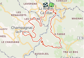
Trail Walking of 12.5 km to be discovered at New Aquitaine, Corrèze, La Roche-Canillac. This trail is proposed by grageot.

Description

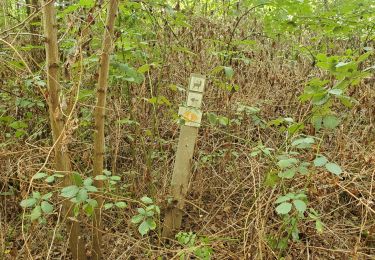
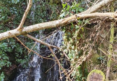
Sept 2020. Belle ballade dans les gorges du Doustre. C'est un ancien parcours tracé dans le sens des aiguilles d'une montre   mais le balisage jaune a quasiment disparu. Pas de difficulté topo les chemins forestiers sont très praticables bien que certains ne soient pas dessinés sur la carte. Les ruines du moulin de la Grave méritent un arrêt.

Elevation profile

Positioning

Country:
France
Region :
New Aquitaine
Department/Province :
Corrèze
Municipality :
La Roche-Canillac
Location:
Unknown
Start:(UTM)
419172 ; 5005225 (31T) N.

Comments

Please log in to post a review or rate the element


Trails nearby

Trail Walking Gros-Chastang - Observatoires des cerfs - Photo
Walking
viam19

Walking

Easy
Gros-Chastang, New Aquitaine, Corrèze, France
7.4 km | 8.5 km-effort
3h 11min
Yes
Trail Walking Saint-Martin-la-Méanne - St-Martin la Méanne_St- Martial-Entraygues - Photo
Walking
viam19

Walking

Difficult
Saint-Martin-la-Méanne, New Aquitaine, Corrèze, France
10.6 km | 16.4 km-effort
6h 18min
No
Trail Walking Gumond - t139496961_circuit du doustre et du plateau des etangs - Photo
Walking
Gpoujade

Walking

Difficult
Gumond, New Aquitaine, Corrèze, France
11.4 km | 15.3 km-effort
3h 28min
Yes
Trail Walking Champagnac-la-Prune - champagnac la prune  - Photo
Walking
miremi

Walking

Medium
Champagnac-la-Prune, New Aquitaine, Corrèze, France
8.3 km | 11 km-effort
3h 8min
No
Trail Walking Gros-Chastang - Gorges Dordogne de Gros Chantant via Couffinier et Brigoux - Photo
Walking
grageot

Walking

Easy
Gros-Chastang, New Aquitaine, Corrèze, France
11.2 km | 15.5 km-effort
2h 55min
Yes
Trail Walking Saint-Martin-la-Méanne - St Martin la Meanne - Argentat par les gorges - Photo
Walking
grageot

Walking

Medium
Saint-Martin-la-Méanne, New Aquitaine, Corrèze, France
19.7 km | 29 km-effort
6h 0min
No
Trail Horseback riding Saint-Paul - rando laborde - Photo
Horseback riding
Melanie19

Horseback riding

Easy
Saint-Paul, New Aquitaine, Corrèze, France
5.5 km | 6.6 km-effort
2h 10min
No
Trail Bicycle tourism Espagnac - reco rando 04-05-24 - Photo
Bicycle tourism
Romain CLÉMENT

Bicycle tourism

Medium
Espagnac, New Aquitaine, Corrèze, France
163 km | 216 km-effort
9h 6min
No
Trail Walking Gumond - la borde - Photo
Walking
chanac les mines

Walking

Very difficult
Gumond, New Aquitaine, Corrèze, France
14.7 km | 19.3 km-effort
3h 48min
Yes


Close
My subscriptions