![](/images/other/stat-length.png)
![Trail Walking Liège - A la découverte de Liège - Photo](https://media.geolcdn.com/t/1900/400/186ecb11-e0f7-4c7a-ab3a-aa244e620c94.jpg&format=pjpeg&maxdim=2)
A la découverte de Liège
mumu.larandonneuse
User GUIDE
![Length](/images/other/stat-length.png)
Length
16.5 km
![Max alt](https://static1.geolcdn.com/siteimages/upload/files/1508320355ic_sort_altitude_max_24dp.png)
Max alt
170 m
![Uphill gradient](https://static1.geolcdn.com/siteimages/upload/files/1508320355ic_sort_den_pos_24dp.png)
Uphill gradient
280 m
![Km-Effort](/images/other/stat-length.png)
Km-Effort
20 km
![Min alt](https://static1.geolcdn.com/siteimages/upload/files/1508320355ic_sort_altitude_min_24dp.png)
Min alt
49 m
![Downhill gradient](https://static1.geolcdn.com/siteimages/upload/files/1508320355ic_sort_den_neg_24dp.png)
Downhill gradient
281 m
![Boucle](https://static1.geolcdn.com/siteimages/upload/files/16400158638029165_repeat_loop_refresh_sync_direction_icon.png)
Boucle
Yes
Creation date :
2020-09-06 08:17:46.386
Updated on :
2020-09-07 18:15:05.82
![Walking](https://static1.geolcdn.com/sitytour/trail-icons/101.png)
4h00
Difficulty : Easy
![Nordic walking](https://static1.geolcdn.com/sitytour/trail-icons/102.png)
4h00
Difficulty : Easy
![Scan this QR Code to open this trail in the SityTrail application](https://capi.geolives.com/qq0zvz2zws4bq2lad0pu/sitytour/trails/2540236/qr.png?size=200)
FREE GPS app for hiking
About
Trail Walking of 16.5 km to be discovered at Wallonia, Liège, Liège. This trail is proposed by mumu.larandonneuse.
Description
Le long de l'Ourthe et de la Meuse, par les coteaux de la citadelle, traversée des parcs (Boverie, Jardin Botanique, Avroy).
Descriptif complet sur www.wandelgidszuidlimburg.com/routes-es-francais n° 1052.
D/A : parking du centre commercial de Belle Ile
Positioning
Country:
Belgium
Region :
Wallonia
Department/Province :
Liège
Municipality :
Liège
Location:
Angleur
Start:(Dec)
Start:(UTM)
683378 ; 5610466 (31U) N.
Comments
Trails nearby
![Trail Walking Chaudfontaine - RB-Lg-21_Chaudfontaine_via-racc-1-et-2 - Photo](https://media.geolcdn.com/t/375/260/ext.jpg?maxdim=2&url=https%3A%2F%2Fservices.sitytrail.com%2FGeolivesWS%2FDownloadMedia.ashx%3FTrailID%3D400756%26Media%3Db4e5d748-2e9a-46aa-887f-e41bafbe80d7.jpg)
![Walking Walking](https://static1.geolcdn.com/sitytour/trail-icons/101.png)
RB-Lg-21_Chaudfontaine_via-racc-1-et-2
Walking
Difficult
(9)
Chaudfontaine,
Wallonia,
Liège,
Belgium
![](/images/other/stat-length.png)
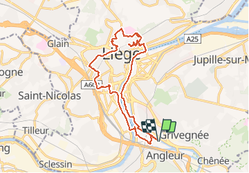
11.6 km | 16.5 km-effort
3h 45min
![](https://static1.geolcdn.com/siteimages/upload/files/16400158638029165_repeat_loop_refresh_sync_direction_icon.png)
Yes
![Trail Walking Chaudfontaine - RB-Lg-21_Chaudfontaine - Photo](https://media.geolcdn.com/t/375/260/ext.jpg?maxdim=2&url=https%3A%2F%2Fservices.sitytrail.com%2FGeolivesWS%2FDownloadMedia.ashx%3FTrailID%3D400753%26Media%3D0173f844-fd8a-4443-984d-43fa65695365.jpg)
![Walking Walking](https://static1.geolcdn.com/sitytour/trail-icons/101.png)
RB-Lg-21_Chaudfontaine
Walking
(14)
Chaudfontaine,
Wallonia,
Liège,
Belgium
![](/images/other/stat-length.png)
18 km | 26 km-effort
5h 56min
![](https://static1.geolcdn.com/siteimages/upload/files/16400158638029165_repeat_loop_refresh_sync_direction_icon.png)
Yes
![Trail Walking Chaudfontaine - Chaudfontaine, Natura 2000 - Des sites qui valent le détour, Lg7 - Photo](https://media.geolcdn.com/t/375/260/ext.jpg?maxdim=2&url=https%3A%2F%2Fservices.sitytrail.com%2FGeolivesWS%2FDownloadMedia.ashx%3FTrailID%3D188128%26Media%3Df5c5efa3-ad1d-47ec-bc6a-d75c5f96ada1.JPG)
![Walking Walking](https://static1.geolcdn.com/sitytour/trail-icons/101.png)
Chaudfontaine, Natura 2000 - Des sites qui valent le détour, Lg7
Walking
Difficult
(14)
Chaudfontaine,
Wallonia,
Liège,
Belgium
![](/images/other/stat-length.png)
5.3 km | 8.7 km-effort
1h 48min
![](https://static1.geolcdn.com/siteimages/upload/files/16400158638029165_repeat_loop_refresh_sync_direction_icon.png)
Yes
![Trail Walking Liège - Nuit du scoutisme - Liège - Photo](https://media.geolcdn.com/t/375/260/9ee5fcc5-2ed6-4f9c-9105-1fa3b4422f73.jpg&format=jpg&maxdim=2)
![Walking Walking](https://static1.geolcdn.com/sitytour/trail-icons/101.png)
Nuit du scoutisme - Liège
Walking
Easy
(12)
Liège,
Wallonia,
Liège,
Belgium
![](/images/other/stat-length.png)
4.2 km | 6 km-effort
1h 19min
![](https://static1.geolcdn.com/siteimages/upload/files/16400158638029165_repeat_loop_refresh_sync_direction_icon.png)
Yes
![Trail Walking Liège - coteaux de la citadelle liège - Photo](https://media.geolcdn.com/t/375/260/ext.jpg?maxdim=2&url=https%3A%2F%2Fservices.sitytrail.com%2FGeolivesWS%2FDownloadMedia.ashx%3FTrailID%3D114030%26Media%3D89e4d7f6-fadf-43e4-96ab-3cccd7baadb9.jpg)
![Walking Walking](https://static1.geolcdn.com/sitytour/trail-icons/101.png)
coteaux de la citadelle liège
Walking
Medium
(6)
Liège,
Wallonia,
Liège,
Belgium
![](/images/other/stat-length.png)
14.3 km | 19.8 km-effort
7h 4min
![](https://static1.geolcdn.com/siteimages/upload/files/16400158638029165_repeat_loop_refresh_sync_direction_icon.png)
Yes
![Trail Walking Liège - GG-Lg-10_Angleur - Nessonvaux - Photo](https://media.geolcdn.com/t/375/260/04d5e1fb-7fbe-4c80-8636-73a8d0ed7b0e.jpg&format=jpg&maxdim=2)
![Walking Walking](https://static1.geolcdn.com/sitytour/trail-icons/101.png)
GG-Lg-10_Angleur - Nessonvaux
Walking
Very difficult
(2)
Liège,
Wallonia,
Liège,
Belgium
![](/images/other/stat-length.png)
22 km | 32 km-effort
6h 27min
![](https://static1.geolcdn.com/siteimages/upload/files/16400158638029165_repeat_loop_refresh_sync_direction_icon.png)
No
![Trail Walking Chaudfontaine - RB-Lg-21_Chaudfontaine_via-racc-1 - Photo](https://media.geolcdn.com/t/375/260/ext.jpg?maxdim=2&url=https%3A%2F%2Fservices.sitytrail.com%2FGeolivesWS%2FDownloadMedia.ashx%3FTrailID%3D400755%26Media%3Db4e5d748-2e9a-46aa-887f-e41bafbe80d7.jpg)
![Walking Walking](https://static1.geolcdn.com/sitytour/trail-icons/101.png)
RB-Lg-21_Chaudfontaine_via-racc-1
Walking
Very difficult
(4)
Chaudfontaine,
Wallonia,
Liège,
Belgium
![](/images/other/stat-length.png)
14.9 km | 22 km-effort
5h 1min
![](https://static1.geolcdn.com/siteimages/upload/files/16400158638029165_repeat_loop_refresh_sync_direction_icon.png)
Yes
![Trail Walking Liège - liege st lambert versant gauche entre ville et nature - Photo](https://media.geolcdn.com/t/375/260/88c52680-ebe2-4244-8d59-4bcee560958c.jpg&format=jpg&maxdim=2)
![Walking Walking](https://static1.geolcdn.com/sitytour/trail-icons/101.png)
liege st lambert versant gauche entre ville et nature
Walking
Medium
(1)
Liège,
Wallonia,
Liège,
Belgium
![](/images/other/stat-length.png)
10.5 km | 14 km-effort
2h 31min
![](https://static1.geolcdn.com/siteimages/upload/files/16400158638029165_repeat_loop_refresh_sync_direction_icon.png)
Yes
![Trail Walking Chaudfontaine - La découverte de Sauheid et rocher du bout du monde - Photo](https://media.geolcdn.com/t/375/260/13dd1432-7408-4af2-9183-0d845172c158.jpg&format=jpg&maxdim=2)
![Walking Walking](https://static1.geolcdn.com/sitytour/trail-icons/101.png)
La découverte de Sauheid et rocher du bout du monde
Walking
Medium
(1)
Chaudfontaine,
Wallonia,
Liège,
Belgium
![](/images/other/stat-length.png)
7.8 km | 10.2 km-effort
2h 18min
![](https://static1.geolcdn.com/siteimages/upload/files/16400158638029165_repeat_loop_refresh_sync_direction_icon.png)
Yes