![](/images/other/stat-length.png)
![Trail Walking Schangnau - Les gorges de l'Emme et les vallons du Siemmenthal - Photo](https://media.geolcdn.com/t/1900/400/ext.pjpeg?maxdim=2&url=https%3A%2F%2Fstatic1.geolcdn.com%2Fsiteimages%2Fupload%2Ffiles%2F1553511878bg_sport_marche.png)
Les gorges de l'Emme et les vallons du Siemmenthal
duamerg
User
![Length](/images/other/stat-length.png)
![Max alt](https://static1.geolcdn.com/siteimages/upload/files/1508320355ic_sort_altitude_max_24dp.png)
![Uphill gradient](https://static1.geolcdn.com/siteimages/upload/files/1508320355ic_sort_den_pos_24dp.png)
![Km-Effort](/images/other/stat-length.png)
![Min alt](https://static1.geolcdn.com/siteimages/upload/files/1508320355ic_sort_altitude_min_24dp.png)
![Downhill gradient](https://static1.geolcdn.com/siteimages/upload/files/1508320355ic_sort_den_neg_24dp.png)
![Boucle](https://static1.geolcdn.com/siteimages/upload/files/16400158638029165_repeat_loop_refresh_sync_direction_icon.png)
![Walking](https://static1.geolcdn.com/sitytour/trail-icons/101.png)
5h00
Difficulty : Medium
![Scan this QR Code to open this trail in the SityTrail application](https://capi.geolives.com/qq0zvz2zws4bq2lad0pu/sitytour/trails/25374/qr.png?size=200)
FREE GPS app for hiking
About
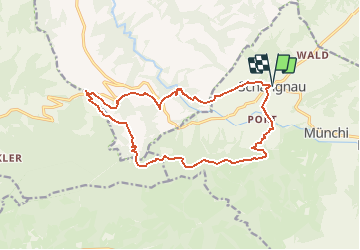
Trail Walking of 16 km to be discovered at Bern, Emmental administrative district, Schangnau. This trail is proposed by duamerg.
Description
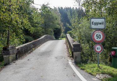
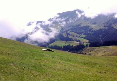
De Schangnau on atteint le le Räbloch (gorges impressionantes de l'Emme) en 45 minutes. Après une forte montée ombragée et sécurisée, l'on atteint la zone protégée du marais de Flüegfäll.
Traverser la route, puis montée au Schallenberg en 1 heure.
Pour le retour, suivre les indications Schangnau par Turner, notre point le plus haut à 1305 mètres.
Après une descente de 200 mètres, il faudra à peu près remonter à 1300m. pour descendre à travers champs jusqu'à Oberi Gemmi.
Dommage que les dernières 45 minutes soient sur du goudron. Il faut dire que l'Emme ne facilite pas les passages possibles!
Possibilité de se restaurer à schangnau et Schallenberg
Positioning
Comments
Trails nearby
![Trail On foot Eggiwil - Heidbüehl - Pfyffer - Photo](https://media.geolcdn.com/t/375/260/0774ec18-94b5-46d6-8206-8c39d06297c6.jpeg&format=jpg&maxdim=2)
![On foot On foot](https://static1.geolcdn.com/sitytour/trail-icons/100.png)
On foot
![](/images/other/stat-length.png)
![](https://static1.geolcdn.com/siteimages/upload/files/16400158638029165_repeat_loop_refresh_sync_direction_icon.png)
![Trail On foot Schangnau - Innereriz - Kemmeribodenbad - Photo](https://media.geolcdn.com/t/375/260/d5281026-cf82-4279-8509-5b0023b426ec.jpeg&format=jpg&maxdim=2)
![On foot On foot](https://static1.geolcdn.com/sitytour/trail-icons/100.png)
On foot
![](/images/other/stat-length.png)
![](https://static1.geolcdn.com/siteimages/upload/files/16400158638029165_repeat_loop_refresh_sync_direction_icon.png)
![Trail On foot Escholzmatt-Marbach - Marbach Talstaion - Marbachegg - Photo](https://media.geolcdn.com/t/375/260/b7f8ab67-e7fd-4b7e-907c-98092d819142.jpeg&format=jpg&maxdim=2)
![On foot On foot](https://static1.geolcdn.com/sitytour/trail-icons/100.png)
On foot
![](/images/other/stat-length.png)
![](https://static1.geolcdn.com/siteimages/upload/files/16400158638029165_repeat_loop_refresh_sync_direction_icon.png)
![Trail On foot Escholzmatt-Marbach - Marbach - Dorfrundweg - Photo](https://media.geolcdn.com/t/375/260/b7f8ab67-e7fd-4b7e-907c-98092d819142.jpeg&format=jpg&maxdim=2)
![On foot On foot](https://static1.geolcdn.com/sitytour/trail-icons/100.png)
On foot
![](/images/other/stat-length.png)
![](https://static1.geolcdn.com/siteimages/upload/files/16400158638029165_repeat_loop_refresh_sync_direction_icon.png)
![Trail On foot Escholzmatt-Marbach - Nesslenboden - Unt. Schübelsmoos - Hürnli - Photo](https://media.geolcdn.com/t/375/260/0f6409d3-b087-4c6d-be0e-bab5ae38458a.jpeg&format=jpg&maxdim=2)
![On foot On foot](https://static1.geolcdn.com/sitytour/trail-icons/100.png)
On foot
![](/images/other/stat-length.png)
![](https://static1.geolcdn.com/siteimages/upload/files/16400158638029165_repeat_loop_refresh_sync_direction_icon.png)
![Trail On foot Escholzmatt-Marbach - Marbachegg - Imbrig - Photo](https://media.geolcdn.com/t/375/260/0f6409d3-b087-4c6d-be0e-bab5ae38458a.jpeg&format=jpg&maxdim=2)
![On foot On foot](https://static1.geolcdn.com/sitytour/trail-icons/100.png)
On foot
![](/images/other/stat-length.png)
![](https://static1.geolcdn.com/siteimages/upload/files/16400158638029165_repeat_loop_refresh_sync_direction_icon.png)
![Trail Other activity Eriz - y10_kemmeriboden - Photo](https://media.geolcdn.com/t/375/260/ext.jpg?maxdim=2&url=https%3A%2F%2Fstatic1.geolcdn.com%2Fsiteimages%2Fupload%2Ffiles%2F1545311037marcheuse_200dpi.jpg)
![Other activity Other activity](https://static1.geolcdn.com/sitytour/trail-icons/900.png)
Other activity
![](/images/other/stat-length.png)
![](https://static1.geolcdn.com/siteimages/upload/files/16400158638029165_repeat_loop_refresh_sync_direction_icon.png)
![Trail Other activity Eriz - Vom Innereriz um die Sieben Hengste - Photo](https://media.geolcdn.com/t/375/260/ext.jpg?maxdim=2&url=https%3A%2F%2Fstatic1.geolcdn.com%2Fsiteimages%2Fupload%2Ffiles%2F1545311037marcheuse_200dpi.jpg)
![Other activity Other activity](https://static1.geolcdn.com/sitytour/trail-icons/900.png)
Other activity
![](/images/other/stat-length.png)
![](https://static1.geolcdn.com/siteimages/upload/files/16400158638029165_repeat_loop_refresh_sync_direction_icon.png)
![Trail Other activity Eriz - 7 Hengste - Photo](https://media.geolcdn.com/t/375/260/ext.jpg?maxdim=2&url=https%3A%2F%2Fstatic1.geolcdn.com%2Fsiteimages%2Fupload%2Ffiles%2F1545311037marcheuse_200dpi.jpg)
![Other activity Other activity](https://static1.geolcdn.com/sitytour/trail-icons/900.png)
Other activity
![](/images/other/stat-length.png)
![](https://static1.geolcdn.com/siteimages/upload/files/16400158638029165_repeat_loop_refresh_sync_direction_icon.png)