Trail Walking Hirtzbach - Hirtzbach - Photo
© OpenStreetMap contributors
Length
Length
10.7 km
Max alt
Max alt
405 m
Uphill gradient
Uphill gradient
219 m
Km-Effort
Km-Effort  
13.6 km
Min alt
Min alt
291 m
Downhill gradient
Downhill gradient
219 m
Boucle
Boucle
Yes
Creation date :
2014-12-10 00:00:00.0
Updated on :
2014-12-10 00:00:00.0

(0 Reviews)

Walking
Walking
2h55
Difficulty : Easy

Scan this QR Code to open this trail in the SityTrail application

FREE GPS app for hiking

Logo SityTrail SityTrail

IGN / Geographical institutes

Download SityTrail from the App Store Download SityTrail from Google Play

Logo SityTrail SityTrail World

The world is yours!

Download SityTrail from the App Store Download SityTrail from Google Play Download SityTrail on Huawei AppGallery

About

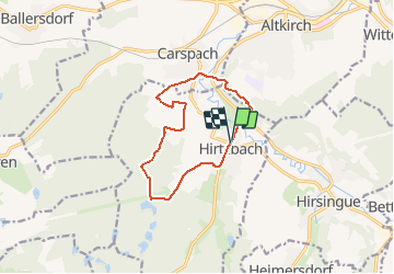
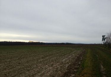
Trail Walking of 10.7 km to be discovered at Grand Est, Haut-Rhin, Hirtzbach. This trail is proposed by regisbodilis.

Description

Au départ au restaurant Ottié à Hirtzbach, suivre la balise " anneau bleu " : l'itinéraire longe la rivière au milieu du village. Magnifique. Par les champs, il mène ensuite aux étangs en très légère montée, puis à la chapelle saint Glucker avant de redescendre sur Carspach pour traverser l'Ill puis la route Altkirch -Ferrette avant de grimper sur l'Illberg sur balise " anneau vert "

Suivre cette balise à l'orée de l'Illberg puis piquer à droite pour redescendre sur Hirtzbach et le point de départ.

Elevation profile

Positioning

Country:
France
Region :
Grand Est
Department/Province :
Haut-Rhin
Municipality :
Hirtzbach
Location:
Unknown
Start:(UTM)
366413 ; 5273234 (32T) N.

Trails nearby

Trail Walking Altkirch - Rando Les Copains d'abord.. 04/03/2022 - Photo
Walking
boubou68

Walking

Medium
Altkirch, Grand Est, Haut-Rhin, France
21 km | 27 km-effort
4h 36min
Yes
Trail Walking Wittersdorf - rdpr wittersdorf matin 220208 - Photo
Walking
GUIDE
stempfel52

Walking

Medium
Wittersdorf, Grand Est, Haut-Rhin, France
8.8 km | 11.5 km-effort
3h 6min
Yes
Trail Walking Carspach - Carspach (21/02/2019) - Photo
Walking
Richard68500

Walking

Easy
Carspach, Grand Est, Haut-Rhin, France
13.2 km | 17.7 km-effort
3h 8min
Yes
Trail Walking Walheim - Walheim-Illfuhrt (1-3-2018) - Photo
Walking
Richard68500

Walking

Easy
Walheim, Grand Est, Haut-Rhin, France
13.6 km | 18.2 km-effort
3h 32min
Yes
Trail Mountain bike Hirsingue - La Schwalmala - 42 km - Photo
Mountain bike
philsutter

Mountain bike

Easy
(1)
Hirsingue, Grand Est, Haut-Rhin, France
41 km | 50 km-effort
3h 13min
Yes
Trail Running Walheim - noel - Photo
Running
flip6868

Running

Easy
Walheim, Grand Est, Haut-Rhin, France
5.3 km | 6.8 km-effort
55min
Yes
Trail Running Walheim - noel - Photo
Running
flip6868

Running

Easy
Walheim, Grand Est, Haut-Rhin, France
5.3 km | 6.8 km-effort
55min
Yes
Trail Mountain bike Walheim - 2010-10-31 - 10h56m09 - Photo
Mountain bike
sergeh68

Mountain bike

Very easy
Walheim, Grand Est, Haut-Rhin, France
34 km | 42 km-effort
Unknown
Yes
Trail Walking Hirtzbach - 68 Hirtzbach - Hirsingue - Photo
Walking
E.BURCK

Walking

Easy
Hirtzbach, Grand Est, Haut-Rhin, France
11.6 km | 14.2 km-effort
3h 13min
No


Close
My subscriptions