Trail Walking Obermorschwiller - Obermorschwiller - Photo
© OpenStreetMap contributors
Length
Length
9.6 km
Max alt
Max alt
362 m
Uphill gradient
Uphill gradient
163 m
Km-Effort
Km-Effort  
11.8 km
Min alt
Min alt
276 m
Downhill gradient
Downhill gradient
162 m
Boucle
Boucle
Yes
Creation date :
2014-12-10 00:00:00.0
Updated on :
2014-12-10 00:00:00.0

(0 Reviews)

Walking
Walking
2h33
Difficulty : Easy

Scan this QR Code to open this trail in the SityTrail application

FREE GPS app for hiking

Logo SityTrail SityTrail

IGN / Geographical institutes

Download SityTrail from the App Store Download SityTrail from Google Play

Logo SityTrail SityTrail World

The world is yours!

Download SityTrail from the App Store Download SityTrail from Google Play Download SityTrail on Huawei AppGallery

About

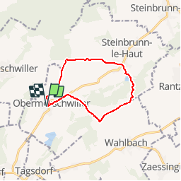
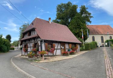
Trail Walking of 9.6 km to be discovered at Grand Est, Haut-Rhin, Obermorschwiller. This trail is proposed by regisbodilis.

Description

A Obermorschwiller, place de l'église, repérer la balise " disque rouge " et la suivre en direction de Zillisheim : première rue à gauche après l'église, puis chemin à droite. Au croisement avec le GR 532 (Rectangle bleu), poursuivre tout droit sur disque rouge jusqu'au croisement avec le sentier balisé " triangle rouge " au pied du Lilienberg. Prendre le triangle rouge à droite pour arriver à Steinbrunn le Haut.

Suivre la balise " triangle rouge " jusqu'à l'intersection avec le GR 532 " Rectangle jaune ". Prendre le GR en direction de Heilhof et Wahlbach. A Heilhof, prendre à droite le chemin balisé " triangle bleu " jusqu'à l'intersection avec le GR 531 " rectangle bleu " en direction d'Obermorschwiller. Arrivé à la route, rejoindre Obermorschwiller par celle-ci.

Elevation profile

Positioning

Country:
France
Region :
Grand Est
Department/Province :
Haut-Rhin
Municipality :
Obermorschwiller
Location:
Unknown
Start:(UTM)
372991 ; 5278060 (32T) N.

Trails nearby

Trail Walking Wittersdorf - rdpr wittersdorf matin 220208 - Photo
Walking
GUIDE
stempfel52

Walking

Medium
Wittersdorf, Grand Est, Haut-Rhin, France
8.8 km | 11.5 km-effort
3h 6min
Yes
Trail Walking Illfurth - Illfurth Luemschwillrr Obermorschwiller - Photo
Walking
selevrich

Walking

Easy
Illfurth, Grand Est, Haut-Rhin, France
28 km | 34 km-effort
3h 28min
No
Trail Walking Walheim - Walheim-Illfuhrt (1-3-2018) - Photo
Walking
Richard68500

Walking

Easy
Walheim, Grand Est, Haut-Rhin, France
13.6 km | 18.2 km-effort
3h 32min
Yes
Trail Running Walheim - noel - Photo
Running
flip6868

Running

Easy
Walheim, Grand Est, Haut-Rhin, France
5.3 km | 6.8 km-effort
55min
Yes
Trail Running Walheim - noel - Photo
Running
flip6868

Running

Easy
Walheim, Grand Est, Haut-Rhin, France
5.3 km | 6.8 km-effort
55min
Yes
Trail Mountain bike Walheim - 2010-10-31 - 10h56m09 - Photo
Mountain bike
sergeh68

Mountain bike

Very easy
Walheim, Grand Est, Haut-Rhin, France
34 km | 42 km-effort
Unknown
Yes
Trail Walking Obermorschwiller - 2022 08 15 - Photo
Walking
jmbilger

Walking

Easy
Obermorschwiller, Grand Est, Haut-Rhin, France
4.4 km | 5.8 km-effort
1h 12min
No
Trail Walking Hausgauen - rdpr hausgauen apm 220208 - Photo
Walking
GUIDE
stempfel52

Walking

Medium
Hausgauen, Grand Est, Haut-Rhin, France
8.2 km | 10.2 km-effort
2h 26min
Yes
Trail Walking Walheim - 2010-11-06 - 16h29m50 - Photo
Walking
sergeh68

Walking

Very easy
Walheim, Grand Est, Haut-Rhin, France
11.3 km | 14.3 km-effort
Unknown
No


Close
My subscriptions