![](/images/other/stat-length.png)
![Trail Walking Pralognan-la-Vanoise - Le lac de la patinoire en partant de Pralognan - Photo](https://media.geolcdn.com/t/1900/400/ext.pjpeg?maxdim=2&url=https%3A%2F%2Fstatic1.geolcdn.com%2Fsiteimages%2Fupload%2Ffiles%2F1553511878bg_sport_marche.png)
Le lac de la patinoire en partant de Pralognan
franquen
User
![Length](/images/other/stat-length.png)
Length
13.6 km
![Max alt](https://static1.geolcdn.com/siteimages/upload/files/1508320355ic_sort_altitude_max_24dp.png)
Max alt
2590 m
![Uphill gradient](https://static1.geolcdn.com/siteimages/upload/files/1508320355ic_sort_den_pos_24dp.png)
Uphill gradient
1482 m
![Km-Effort](/images/other/stat-length.png)
Km-Effort
33 km
![Min alt](https://static1.geolcdn.com/siteimages/upload/files/1508320355ic_sort_altitude_min_24dp.png)
Min alt
1408 m
![Downhill gradient](https://static1.geolcdn.com/siteimages/upload/files/1508320355ic_sort_den_neg_24dp.png)
Downhill gradient
1478 m
![Boucle](https://static1.geolcdn.com/siteimages/upload/files/16400158638029165_repeat_loop_refresh_sync_direction_icon.png)
Boucle
Yes
Creation date :
2020-08-27 06:58:46.879
Updated on :
2020-08-27 15:14:33.088
![Walking](https://static1.geolcdn.com/sitytour/trail-icons/101.png)
5h16
Difficulty : Easy
![Scan this QR Code to open this trail in the SityTrail application](https://capi.geolives.com/qq0zvz2zws4bq2lad0pu/sitytour/trails/2529355/qr.png?size=200)
FREE GPS app for hiking
About
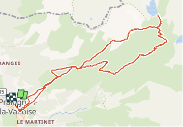
Trail Walking of 13.6 km to be discovered at Auvergne-Rhône-Alpes, Savoy, Pralognan-la-Vanoise. This trail is proposed by franquen.
Description
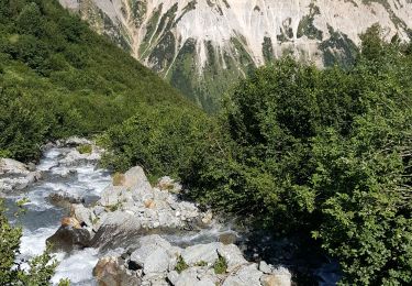
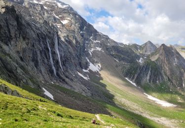
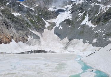
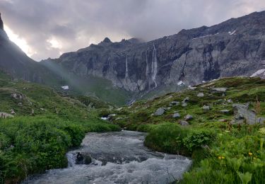
Très belle rando dans le parc de la Vanoise . le glacier de la grande Casse est majestueux.
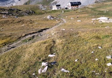
Départ et arrivée par le téléphérique du Bochor , il faut donc enlever 600m aux dénivelés cumulés.
Positioning
Country:
France
Region :
Auvergne-Rhône-Alpes
Department/Province :
Savoy
Municipality :
Pralognan-la-Vanoise
Location:
Unknown
Start:(Dec)
Start:(UTM)
321541 ; 5027925 (32T) N.
Comments
Trails nearby
![Trail Walking Pralognan-la-Vanoise - Pralognan - Les Prioux Lac de Chalet Clou - Photo](https://media.geolcdn.com/t/375/260/aef0b6ed-57e6-4d04-a75d-d2ffe6e61cd4.jpg&format=jpg&maxdim=2)
![Walking Walking](https://static1.geolcdn.com/sitytour/trail-icons/101.png)
Pralognan - Les Prioux Lac de Chalet Clou
Walking
Easy
(3)
Pralognan-la-Vanoise,
Auvergne-Rhône-Alpes,
Savoy,
France
![](/images/other/stat-length.png)
11 km | 19.3 km-effort
4h 41min
![](https://static1.geolcdn.com/siteimages/upload/files/16400158638029165_repeat_loop_refresh_sync_direction_icon.png)
Yes
![Trail Walking Pralognan-la-Vanoise - Pralognan - la crête du mont Charvet - Photo](https://media.geolcdn.com/t/375/260/54cee105-6456-408f-be19-9af4b98c1ac1.jpg&format=jpg&maxdim=2)
![Walking Walking](https://static1.geolcdn.com/sitytour/trail-icons/101.png)
Pralognan - la crête du mont Charvet
Walking
Medium
(1)
Pralognan-la-Vanoise,
Auvergne-Rhône-Alpes,
Savoy,
France
![](/images/other/stat-length.png)
11.4 km | 24 km-effort
5h 1min
![](https://static1.geolcdn.com/siteimages/upload/files/16400158638029165_repeat_loop_refresh_sync_direction_icon.png)
No
![Trail Walking Val-Cenis - traversée Valette f faure - Photo](https://media.geolcdn.com/t/375/260/1679692e-b77c-47af-aee2-08c69ff92bec.jpg&format=jpg&maxdim=2)
![Walking Walking](https://static1.geolcdn.com/sitytour/trail-icons/101.png)
traversée Valette f faure
Walking
Difficult
Val-Cenis,
Auvergne-Rhône-Alpes,
Savoy,
France
![](/images/other/stat-length.png)
8.7 km | 13.8 km-effort
8h 24min
![](https://static1.geolcdn.com/siteimages/upload/files/16400158638029165_repeat_loop_refresh_sync_direction_icon.png)
No
![Trail Walking Pralognan-la-Vanoise - pointe de Leschaux - Photo](https://media.geolcdn.com/t/375/260/c0179711-7974-4489-9ffb-171084fcf8a1.jpg&format=jpg&maxdim=2)
![Walking Walking](https://static1.geolcdn.com/sitytour/trail-icons/101.png)
pointe de Leschaux
Walking
Difficult
Pralognan-la-Vanoise,
Auvergne-Rhône-Alpes,
Savoy,
France
![](/images/other/stat-length.png)
12 km | 28 km-effort
5h 43min
![](https://static1.geolcdn.com/siteimages/upload/files/16400158638029165_repeat_loop_refresh_sync_direction_icon.png)
Yes
![Trail Walking Planay - la cascade de la Vuzelle - Photo](https://media.geolcdn.com/t/375/260/04c5b92c-2692-443b-b1c5-903e48f44ec5.jpg&format=jpg&maxdim=2)
![Walking Walking](https://static1.geolcdn.com/sitytour/trail-icons/101.png)
la cascade de la Vuzelle
Walking
Medium
Planay,
Auvergne-Rhône-Alpes,
Savoy,
France
![](/images/other/stat-length.png)
4.3 km | 10.4 km-effort
2h 21min
![](https://static1.geolcdn.com/siteimages/upload/files/16400158638029165_repeat_loop_refresh_sync_direction_icon.png)
Yes
![Trail Walking Pralognan-la-Vanoise - traversée des Fontanettes aux Prioux par le col du Grand marchet - Photo](https://media.geolcdn.com/t/375/260/24a33514-db38-4400-a38f-98ffcbd53fe7.jpg&format=jpg&maxdim=2)
![Walking Walking](https://static1.geolcdn.com/sitytour/trail-icons/101.png)
traversée des Fontanettes aux Prioux par le col du Grand marchet
Walking
Difficult
Pralognan-la-Vanoise,
Auvergne-Rhône-Alpes,
Savoy,
France
![](/images/other/stat-length.png)
13.7 km | 30 km-effort
6h 51min
![](https://static1.geolcdn.com/siteimages/upload/files/16400158638029165_repeat_loop_refresh_sync_direction_icon.png)
No
![Trail Walking Pralognan-la-Vanoise - le lac de la patinoire - Photo](https://media.geolcdn.com/t/375/260/88bae2e9-35f9-4ca5-a526-616594e07db8.jpg&format=jpg&maxdim=2)
![Walking Walking](https://static1.geolcdn.com/sitytour/trail-icons/101.png)
le lac de la patinoire
Walking
Difficult
Pralognan-la-Vanoise,
Auvergne-Rhône-Alpes,
Savoy,
France
![](/images/other/stat-length.png)
11.3 km | 22 km-effort
5h 40min
![](https://static1.geolcdn.com/siteimages/upload/files/16400158638029165_repeat_loop_refresh_sync_direction_icon.png)
Yes
![Trail Walking Pralognan-la-Vanoise - col de napremont - Photo](https://media.geolcdn.com/t/375/260/6fea95cc-6da2-44f1-9ef9-b36a9d856ac2.jpg&format=jpg&maxdim=2)
![Walking Walking](https://static1.geolcdn.com/sitytour/trail-icons/101.png)
col de napremont
Walking
Easy
Pralognan-la-Vanoise,
Auvergne-Rhône-Alpes,
Savoy,
France
![](/images/other/stat-length.png)
9.4 km | 19.4 km-effort
4h 24min
![](https://static1.geolcdn.com/siteimages/upload/files/16400158638029165_repeat_loop_refresh_sync_direction_icon.png)
Yes
![Trail Walking Pralognan-la-Vanoise - 2022-06-28 Marche TGV Refuge Valette Pralognan - Photo](https://media.geolcdn.com/t/375/260/64cb2300-ba57-4fac-bb37-92f95e3da956.jpg&format=jpg&maxdim=2)
![Walking Walking](https://static1.geolcdn.com/sitytour/trail-icons/101.png)
2022-06-28 Marche TGV Refuge Valette Pralognan
Walking
Easy
Pralognan-la-Vanoise,
Auvergne-Rhône-Alpes,
Savoy,
France
![](/images/other/stat-length.png)
8.4 km | 16 km-effort
4h 20min
![](https://static1.geolcdn.com/siteimages/upload/files/16400158638029165_repeat_loop_refresh_sync_direction_icon.png)
No