Trail Walking Plouha - Gwin Zegal Le Palus Boucle - Photo

Gwin Zegal Le Palus Boucle

© OpenStreetMap contributors
Length
Length
12.8 km
Max alt
Max alt
108 m
Uphill gradient
Uphill gradient
217 m
Km-Effort
Km-Effort  
15.7 km
Min alt
Min alt
1 m
Downhill gradient
Downhill gradient
217 m
Boucle
Boucle
Yes
Creation date :
2020-08-24 07:44:17.215
Updated on :
2020-08-24 13:57:16.303

(0 Reviews)

Walking
Walking
3h02
Difficulty : Easy

Scan this QR Code to open this trail in the SityTrail application

FREE GPS app for hiking

Logo SityTrail SityTrail

IGN / Geographical institutes

Download SityTrail from the App Store Download SityTrail from Google Play

Logo SityTrail SityTrail World

The world is yours!

Download SityTrail from the App Store Download SityTrail from Google Play Download SityTrail on Huawei AppGallery

About

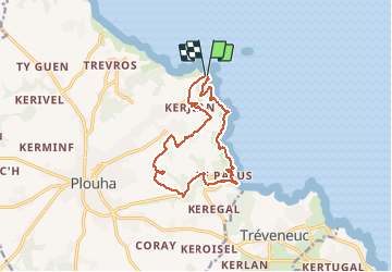
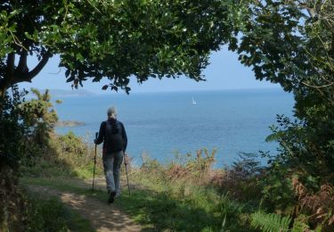
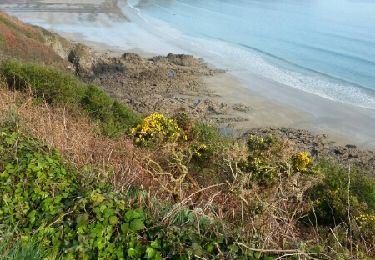
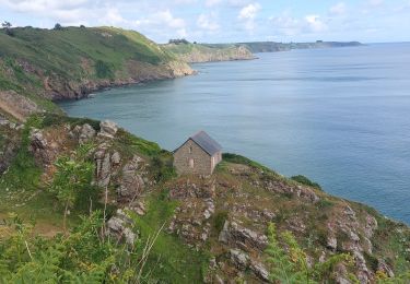
Trail Walking of 12.8 km to be discovered at Brittany, Côtes-d'Armor, Plouha. This trail is proposed by Randosdeguy.

Description

Randonnée en boucle.
Après Le Palus possibilité d'agrandir la boucle via Keregal

Elevation profile

Positioning

Country:
France
Region :
Brittany
Department/Province :
Côtes-d'Armor
Municipality :
Plouha
Location:
Unknown
Start:(UTM)
507926 ; 5393875 (30U) N.

Trails nearby

Trail Walking Tréveneuc - Tréveneuc Chapelle Saint-Marc - GR34 Plage de la Banche - 24.8km 420m 5h35 (40mn) - 2024 07 03 - Photo
Walking
GUIDE
Orcal37

Walking

Difficult
Tréveneuc, Brittany, Côtes-d'Armor, France
25 km | 30 km-effort
5h 35min
Yes
Trail Walking Plouha - Plouha Plage Bonaparte - GR34 Chapelle Saint-Marc - 22.9km 465m 5h20 (35mn) - 2024 07 02 - Photo
Walking
GUIDE
Orcal37

Walking

Difficult
Plouha, Brittany, Côtes-d'Armor, France
23 km | 29 km-effort
5h 20min
Yes
Trail Walking Plouha - GR_34_CG_20_Plouha_Plouezec_20240528 - Photo
Walking
patrickdanilo

Walking

Medium
Plouha, Brittany, Côtes-d'Armor, France
12.2 km | 16.5 km-effort
3h 26min
No
Trail Walking Plouha - Falaises de Plouha 9.7.23 - Photo
Walking
GUIDE
fredetpascale

Walking

Easy
Plouha, Brittany, Côtes-d'Armor, France
14.8 km | 20 km-effort
2h 50min
No
Trail Walking Plouha - plouha plage Bonaparte 5km - Photo
Walking
Vasseur Jean Marc

Walking

Very difficult
Plouha, Brittany, Côtes-d'Armor, France
24 km | 28 km-effort
3h 6min
No
Trail Walking Plouha - Falaises de Plouha - Photo
Walking
TOULAUDIN

Walking

Medium
(1)
Plouha, Brittany, Côtes-d'Armor, France
16.2 km | 21 km-effort
5h 44min
Yes
Trail Walking Plouha - A 13 De la Plage Bonaparte - Photo
Walking
vindju

Walking

Very easy
Plouha, Brittany, Côtes-d'Armor, France
15.4 km | 19.7 km-effort
4h 21min
Yes
Trail Walking Saint-Quay-Portrieux - GR 34 étape 18 - Photo
Walking
lagardienne

Walking

Easy
Saint-Quay-Portrieux, Brittany, Côtes-d'Armor, France
31 km | 41 km-effort
8h 33min
No
Trail Walking Tréveneuc - GR_34_CF_19_Treveneuc_Plouha_20240527 - Photo
Walking
patrickdanilo

Walking

Medium
Tréveneuc, Brittany, Côtes-d'Armor, France
10.1 km | 13.7 km-effort
3h 7min
No


Close
My subscriptions