![](/images/other/stat-length.png)
![Trail On foot Rosnay - 2020-08-24_10h41m50_SityTrail - 2519690 - les-vignes-et-la-vallexe-de-lxyon---nx15 - Photo](https://media.geolcdn.com/t/1900/400/ext.pjpeg?maxdim=2&url=https%3A%2F%2Fstatic1.geolcdn.com%2Fsiteimages%2Fupload%2Ffiles%2F1545311037marcheuse_200dpi.jpg)
2020-08-24_10h41m50_SityTrail - 2519690 - les-vignes-et-la-vallexe-de-lxyon---nx15
Gregory Herlaud
User
![Length](/images/other/stat-length.png)
![Max alt](https://static1.geolcdn.com/siteimages/upload/files/1508320355ic_sort_altitude_max_24dp.png)
![Uphill gradient](https://static1.geolcdn.com/siteimages/upload/files/1508320355ic_sort_den_pos_24dp.png)
![Km-Effort](/images/other/stat-length.png)
![Min alt](https://static1.geolcdn.com/siteimages/upload/files/1508320355ic_sort_altitude_min_24dp.png)
![Downhill gradient](https://static1.geolcdn.com/siteimages/upload/files/1508320355ic_sort_den_neg_24dp.png)
![Boucle](https://static1.geolcdn.com/siteimages/upload/files/16400158638029165_repeat_loop_refresh_sync_direction_icon.png)
![On foot](https://static1.geolcdn.com/sitytour/trail-icons/100.png)
3h20
Difficulty : Easy
![Scan this QR Code to open this trail in the SityTrail application](https://capi.geolives.com/qq0zvz2zws4bq2lad0pu/sitytour/trails/2525963/qr.png?size=200)
FREE GPS app for hiking
About
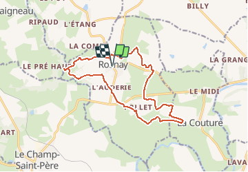
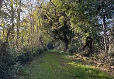
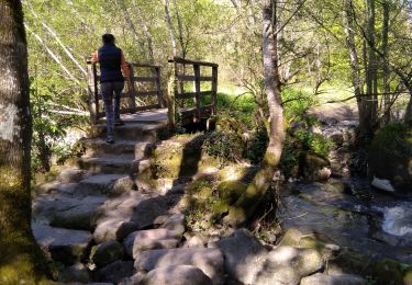
Trail On foot of 15.6 km to be discovered at Pays de la Loire, Vendée, Rosnay. This trail is proposed by Gregory Herlaud.
Description
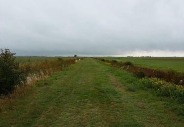
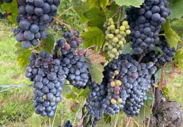
Ce sentier vous permettra de découvrir l'une des spécialités du Pays Mareuillais : le vin. Tout au long du parcours, vous pourrez déguster des vins* AOC (Appellation d'Origine Contrôlée) de nos viticulteurs à travers un paysage magnifique aux couleurs changeantes selon les saisons. Dès le XIIème siècle, le vignoble de la région de Mareuil est cité pour le valeur de ses crus. Actuellement, il s'étend sur 320 ha dont 240 ha à Rosnay. Les vins des Fiefs Vendéens sont des vins légers et aromatiques à boire jeunes. Au départ de l'église de Rosnay, vous traverserez la campagne pour rejoindre les marais avant de découvrir le site de Pierres Folles. Ces menhirs datant de 3000 ans avant Jésus-Christ et pesant 11 et 15 tonnes, proviendraient de la vallée de l'Yon, située à plus de 2 km. Vous rejoindrez ensuite la vallée de l'Yon puis la Chaussée de Chavagne en empruntant l'un des deux chemins qui vont sont proposés. Cette rivière termine son voyage à Rosnay, formant une vallée très encaissée au pied des coteaux, avant de se jeter dans le Lay. *l'abus d'alcool est dangereux pour la santé. A consommer avec modération.
Positioning
Comments
Trails nearby
![Trail Walking Le Champ-Saint-Père - (Compostelle) du Champ Saint Père à Triaize - Photo](https://media.geolcdn.com/t/375/260/ext.jpg?maxdim=2&url=https%3A%2F%2Fservices.sitytrail.com%2FGeolivesWS%2FDownloadMedia.ashx%3FTrailID%3D333957%26Media%3D1953e10c-0c53-497b-afa0-fa5c0d5bdf53.jpg)
![Walking Walking](https://static1.geolcdn.com/sitytour/trail-icons/101.png)
Walking
![](/images/other/stat-length.png)
![](https://static1.geolcdn.com/siteimages/upload/files/16400158638029165_repeat_loop_refresh_sync_direction_icon.png)
![Trail Walking Rives-de-l'Yon - caille les orneaux - Photo](https://media.geolcdn.com/t/375/260/f4e8f30c-7059-4efc-827f-9cf894c1224d.jpg&format=jpg&maxdim=2)
![Walking Walking](https://static1.geolcdn.com/sitytour/trail-icons/101.png)
Walking
![](/images/other/stat-length.png)
![](https://static1.geolcdn.com/siteimages/upload/files/16400158638029165_repeat_loop_refresh_sync_direction_icon.png)
![Trail Walking Le Tablier - la vallée de l'Yon 9 - Photo](https://media.geolcdn.com/t/375/260/ext.jpg?maxdim=2&url=https%3A%2F%2Fstatic1.geolcdn.com%2Fsiteimages%2Fupload%2Ffiles%2F1553511878bg_sport_marche.png)
![Walking Walking](https://static1.geolcdn.com/sitytour/trail-icons/101.png)
Walking
![](/images/other/stat-length.png)
![](https://static1.geolcdn.com/siteimages/upload/files/16400158638029165_repeat_loop_refresh_sync_direction_icon.png)
![Trail Walking Rosnay - Les Vignes et la Vallée de l'Yon - N°15 - Photo](https://media.geolcdn.com/t/375/260/aa89ada1-4ce5-41ff-b125-e448f15654ec.jpg&format=jpg&maxdim=2)
![Walking Walking](https://static1.geolcdn.com/sitytour/trail-icons/101.png)
Walking
![](/images/other/stat-length.png)
![](https://static1.geolcdn.com/siteimages/upload/files/16400158638029165_repeat_loop_refresh_sync_direction_icon.png)
![Trail Walking Rosnay - R5 - Rosnay vignes - Photo](https://media.geolcdn.com/t/375/260/ext.jpg?maxdim=2&url=https%3A%2F%2Fstatic1.geolcdn.com%2Fsiteimages%2Fupload%2Ffiles%2F1553511878bg_sport_marche.png)
![Walking Walking](https://static1.geolcdn.com/sitytour/trail-icons/101.png)
Walking
![](/images/other/stat-length.png)
![](https://static1.geolcdn.com/siteimages/upload/files/16400158638029165_repeat_loop_refresh_sync_direction_icon.png)
![Trail Walking Rives-de-l'Yon - Chaillé sous les Orrmeaux - Photo](https://media.geolcdn.com/t/375/260/ext.jpg?maxdim=2&url=https%3A%2F%2Fstatic1.geolcdn.com%2Fsiteimages%2Fupload%2Ffiles%2F1553511878bg_sport_marche.png)
![Walking Walking](https://static1.geolcdn.com/sitytour/trail-icons/101.png)
Walking
![](/images/other/stat-length.png)
![](https://static1.geolcdn.com/siteimages/upload/files/16400158638029165_repeat_loop_refresh_sync_direction_icon.png)
![Trail On foot Le Champ-Saint-Père - SityTrail - Test champ st père sitytrai + - Photo](https://media.geolcdn.com/t/375/260/ext.jpg?maxdim=2&url=https%3A%2F%2Fstatic1.geolcdn.com%2Fsiteimages%2Fupload%2Ffiles%2F1545311037marcheuse_200dpi.jpg)
![On foot On foot](https://static1.geolcdn.com/sitytour/trail-icons/100.png)
On foot
![](/images/other/stat-length.png)
![](https://static1.geolcdn.com/siteimages/upload/files/16400158638029165_repeat_loop_refresh_sync_direction_icon.png)
![Trail Walking Le Champ-Saint-Père - Test champ st père sitytrai + - Photo](https://media.geolcdn.com/t/375/260/b797ba84-1c80-4a49-a180-71a69cec6f80.jpg&format=jpg&maxdim=2)
![Walking Walking](https://static1.geolcdn.com/sitytour/trail-icons/101.png)
Walking
![](/images/other/stat-length.png)
![](https://static1.geolcdn.com/siteimages/upload/files/16400158638029165_repeat_loop_refresh_sync_direction_icon.png)
![Trail Walking Le Tablier - le petit piquet - Photo](https://media.geolcdn.com/t/375/260/592ee705-dc08-4233-9012-e5c19068b97c.jpg&format=jpg&maxdim=2)
![Walking Walking](https://static1.geolcdn.com/sitytour/trail-icons/101.png)
Walking
![](/images/other/stat-length.png)
![](https://static1.geolcdn.com/siteimages/upload/files/16400158638029165_repeat_loop_refresh_sync_direction_icon.png)