![](/images/other/stat-length.png)
![Trail Walking Susville - Sénépy sans le Sénépy depuis les Merlins - Photo](https://media.geolcdn.com/t/1900/400/ext.pjpeg?maxdim=2&url=https%3A%2F%2Fstatic1.geolcdn.com%2Fsiteimages%2Fupload%2Ffiles%2F1553511878bg_sport_marche.png)
Sénépy sans le Sénépy depuis les Merlins
cmarit
User
![Length](/images/other/stat-length.png)
![Max alt](https://static1.geolcdn.com/siteimages/upload/files/1508320355ic_sort_altitude_max_24dp.png)
![Uphill gradient](https://static1.geolcdn.com/siteimages/upload/files/1508320355ic_sort_den_pos_24dp.png)
![Km-Effort](/images/other/stat-length.png)
![Min alt](https://static1.geolcdn.com/siteimages/upload/files/1508320355ic_sort_altitude_min_24dp.png)
![Downhill gradient](https://static1.geolcdn.com/siteimages/upload/files/1508320355ic_sort_den_neg_24dp.png)
![Boucle](https://static1.geolcdn.com/siteimages/upload/files/16400158638029165_repeat_loop_refresh_sync_direction_icon.png)
![Walking](https://static1.geolcdn.com/sitytour/trail-icons/101.png)
4h37
Difficulty : Easy
![Scan this QR Code to open this trail in the SityTrail application](https://capi.geolives.com/qq0zvz2zws4bq2lad0pu/sitytour/trails/2525098/qr.png?size=200)
FREE GPS app for hiking
About
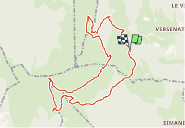
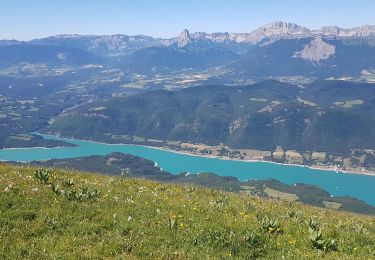
Trail Walking of 12.3 km to be discovered at Auvergne-Rhône-Alpes, Isère, Susville. This trail is proposed by cmarit.
Description
Nous avions projeté d'aller au Sénépy depuis les Merlins.
Arrivés au col du Sénépy, le fort vent et le brouillard sur le mont nous ont incité à prendre vers le bas!...
nous avons emprunté le parcours marqué en pointillés sur la carte. Sur le terrain, quelques sentes de vaches ou rien, mais le cheminement reste évident avec le relief.
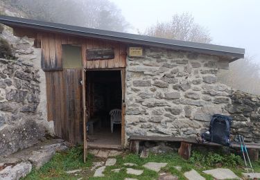
Nous avons pique-niqué à l'altitude 1330m sur le chemin du retour, car très bien protégé du vent.
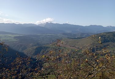
Comme il était tôt, nous sommes remontés sur la tête de Chame-rousse: le nom me plaisait.
Le chemin aussi fut agréable, et pas vilain du tout.
Ensuite nous avons rejoint la crête (1576m) pour redescendre et rejoindre le col de brame-farine puis les Merlins.
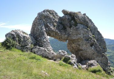
C'est le paradis des vaches ce coin là ! et ce fut une belle découverte hors des sentiers battus pour nous!
nous n'avons pas regretté le sommet du Sénépy que nous connaissons bien.
Positioning
Comments
Trails nearby
![Trail Road bike La Mure - La Mure les 4 lacs - Photo](https://media.geolcdn.com/t/375/260/ext.jpg?maxdim=2&url=https%3A%2F%2Fstatic1.geolcdn.com%2Fsiteimages%2Fupload%2Ffiles%2F1524743154velo.jpg)
![Road bike Road bike](https://static1.geolcdn.com/sitytour/trail-icons/201.png)
Road bike
![](/images/other/stat-length.png)
![](https://static1.geolcdn.com/siteimages/upload/files/16400158638029165_repeat_loop_refresh_sync_direction_icon.png)
![Walking Walking](https://static1.geolcdn.com/sitytour/trail-icons/101.png)
Walking
![](/images/other/stat-length.png)
![](https://static1.geolcdn.com/siteimages/upload/files/16400158638029165_repeat_loop_refresh_sync_direction_icon.png)
![Trail Walking La Motte-d'Aveillans - petite balade - Photo](https://media.geolcdn.com/t/375/260/c8ab192f-feb7-4747-af86-e7381ac953ed.jpg&format=jpg&maxdim=2)
![Walking Walking](https://static1.geolcdn.com/sitytour/trail-icons/101.png)
Walking
![](/images/other/stat-length.png)
![](https://static1.geolcdn.com/siteimages/upload/files/16400158638029165_repeat_loop_refresh_sync_direction_icon.png)
![Trail Walking Mayres-Savel - Passerelles Hymalayene Mayres + 250 - Photo](https://media.geolcdn.com/t/375/260/e79ec6b2-c62a-43e0-95ca-91baa034bf5d.jpg&format=jpg&maxdim=2)
![Walking Walking](https://static1.geolcdn.com/sitytour/trail-icons/101.png)
Walking
![](/images/other/stat-length.png)
![](https://static1.geolcdn.com/siteimages/upload/files/16400158638029165_repeat_loop_refresh_sync_direction_icon.png)
![Trail Walking Susville - Susville les Merlins boucle par le col du Sénépiy - Photo](https://media.geolcdn.com/t/375/260/e34bcbf0-51cf-49b5-a532-234a88d268fc.jpg&format=jpg&maxdim=2)
![Walking Walking](https://static1.geolcdn.com/sitytour/trail-icons/101.png)
Walking
![](/images/other/stat-length.png)
![](https://static1.geolcdn.com/siteimages/upload/files/16400158638029165_repeat_loop_refresh_sync_direction_icon.png)
![Trail Walking Mayres-Savel - Randonnée des passerelles - Photo](https://media.geolcdn.com/t/375/260/f81885ad-9d99-466e-990d-175fbd3a925e.jpg&format=jpg&maxdim=2)
![Walking Walking](https://static1.geolcdn.com/sitytour/trail-icons/101.png)
Walking
![](/images/other/stat-length.png)
![](https://static1.geolcdn.com/siteimages/upload/files/16400158638029165_repeat_loop_refresh_sync_direction_icon.png)
![Trail Walking La Motte-Saint-Martin - Sinepi - Photo](https://media.geolcdn.com/t/375/260/ext.jpg?maxdim=2&url=https%3A%2F%2Fstatic1.geolcdn.com%2Fsiteimages%2Fupload%2Ffiles%2F1553511878bg_sport_marche.png)
![Walking Walking](https://static1.geolcdn.com/sitytour/trail-icons/101.png)
Walking
![](/images/other/stat-length.png)
![](https://static1.geolcdn.com/siteimages/upload/files/16400158638029165_repeat_loop_refresh_sync_direction_icon.png)
![Trail Mountain bike La Motte-d'Aveillans - Le Sénépy depuis Les Signaraux - Photo](https://media.geolcdn.com/t/375/260/48b7fa7e-1a2a-4b01-b381-61d2b963f1f0.jpg&format=jpg&maxdim=2)
![Mountain bike Mountain bike](https://static1.geolcdn.com/sitytour/trail-icons/202.png)
Mountain bike
![](/images/other/stat-length.png)
![](https://static1.geolcdn.com/siteimages/upload/files/16400158638029165_repeat_loop_refresh_sync_direction_icon.png)
![Trail Walking La Motte-d'Aveillans - Col du Sénépy et Pierre Plantée depuis les Signaraux - Photo](https://media.geolcdn.com/t/375/260/cfea585a-9c0d-41ae-ace9-cab390a4faa0.jpg&format=jpg&maxdim=2)
![Walking Walking](https://static1.geolcdn.com/sitytour/trail-icons/101.png)
Walking
![](/images/other/stat-length.png)
![](https://static1.geolcdn.com/siteimages/upload/files/16400158638029165_repeat_loop_refresh_sync_direction_icon.png)