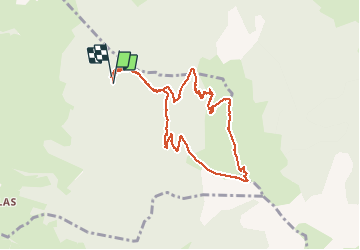
![](/images/other/stat-length.png)
![Trail Walking Mens - Le châtel du parking du baret - Photo](https://media.geolcdn.com/t/1900/400/2a1530ed-ec4f-4ed8-be69-3d3ace898c66.jpg&format=pjpeg&maxdim=2)
Le châtel du parking du baret
perrierf
User
![Length](/images/other/stat-length.png)
![Max alt](https://static1.geolcdn.com/siteimages/upload/files/1508320355ic_sort_altitude_max_24dp.png)
![Uphill gradient](https://static1.geolcdn.com/siteimages/upload/files/1508320355ic_sort_den_pos_24dp.png)
![Km-Effort](/images/other/stat-length.png)
![Min alt](https://static1.geolcdn.com/siteimages/upload/files/1508320355ic_sort_altitude_min_24dp.png)
![Downhill gradient](https://static1.geolcdn.com/siteimages/upload/files/1508320355ic_sort_den_neg_24dp.png)
![Boucle](https://static1.geolcdn.com/siteimages/upload/files/16400158638029165_repeat_loop_refresh_sync_direction_icon.png)
![Walking](https://static1.geolcdn.com/sitytour/trail-icons/101.png)
4h02
Difficulty : Medium
![Scan this QR Code to open this trail in the SityTrail application](https://capi.geolives.com/qq0zvz2zws4bq2lad0pu/sitytour/trails/2524404/qr.png?size=200)
FREE GPS app for hiking
About
Trail Walking of 8.9 km to be discovered at Auvergne-Rhône-Alpes, Isère, Mens. This trail is proposed by perrierf.
Description
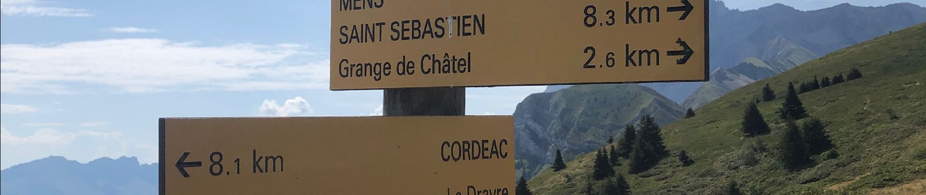
À partir du parking du baret à 15 ‘ de men’s en voiture.
Boucle et sommet du chatel à faire en famille.
Le dépliant de rando du trieves et les panneaux proposent la boucle en 3h30 mais nous l’avons fait en 4h tranquille.
Rando faite avec enfant de 7 ans .
Dénivellation : 620 / -
Attention le passage au col de la breche ( main courante, risque de chute de pierres
Positioning
Comments
Trails nearby
![Trail Walking Châtel-en-Trièves - Arête de Rattier depuis le col de la brêche - Photo](https://media.geolcdn.com/t/375/260/645aac14-c825-4b01-9c22-da781fdfea33.jpg&format=jpg&maxdim=2)
![Walking Walking](https://static1.geolcdn.com/sitytour/trail-icons/101.png)
Walking
![](/images/other/stat-length.png)
![](https://static1.geolcdn.com/siteimages/upload/files/16400158638029165_repeat_loop_refresh_sync_direction_icon.png)
![Trail Walking Mens - Bonnet Calvin reco - Photo](https://media.geolcdn.com/t/375/260/71237d58-2b29-4521-9351-2dded8929675.jpg&format=jpg&maxdim=2)
![Walking Walking](https://static1.geolcdn.com/sitytour/trail-icons/101.png)
Walking
![](/images/other/stat-length.png)
![](https://static1.geolcdn.com/siteimages/upload/files/16400158638029165_repeat_loop_refresh_sync_direction_icon.png)
![Trail Walking Saint-Baudille-et-Pipet - Bonnet de Calvin - Photo](https://media.geolcdn.com/t/375/260/b711d778-2624-48ca-9a09-33141db7aca2.jpg&format=jpg&maxdim=2)
![Walking Walking](https://static1.geolcdn.com/sitytour/trail-icons/101.png)
Walking
![](/images/other/stat-length.png)
![](https://static1.geolcdn.com/siteimages/upload/files/16400158638029165_repeat_loop_refresh_sync_direction_icon.png)
![Trail Walking Saint-Baudille-et-Pipet - Des Lames d'Arçon au Col de l'Aiguille - Photo](https://media.geolcdn.com/t/375/260/6a7d919f-0a46-4fb6-a03a-1cd4dec1d339.jpg&format=jpg&maxdim=2)
![Walking Walking](https://static1.geolcdn.com/sitytour/trail-icons/101.png)
Walking
![](/images/other/stat-length.png)
![](https://static1.geolcdn.com/siteimages/upload/files/16400158638029165_repeat_loop_refresh_sync_direction_icon.png)
![Trail Walking Mens - bonnet de Calvin - Photo](https://media.geolcdn.com/t/375/260/809ecc75-03b4-4bae-9bda-776611be3043.jpg&format=jpg&maxdim=2)
![Walking Walking](https://static1.geolcdn.com/sitytour/trail-icons/101.png)
Walking
![](/images/other/stat-length.png)
![](https://static1.geolcdn.com/siteimages/upload/files/16400158638029165_repeat_loop_refresh_sync_direction_icon.png)
![Trail Walking Mens - Esclops Trièves Tour de Mens - Photo](https://media.geolcdn.com/t/375/260/009e9f5f-8365-4132-9701-b10e3311f406.jpg&format=jpg&maxdim=2)
![Walking Walking](https://static1.geolcdn.com/sitytour/trail-icons/101.png)
Walking
![](/images/other/stat-length.png)
![](https://static1.geolcdn.com/siteimages/upload/files/16400158638029165_repeat_loop_refresh_sync_direction_icon.png)
![Trail Walking Saint-Baudille-et-Pipet - Esclops Trièves Col de l'Aiguille - Photo](https://media.geolcdn.com/t/375/260/c1c5675d-bfe6-4e05-80f5-bbfac132efec.jpg&format=jpg&maxdim=2)
![Walking Walking](https://static1.geolcdn.com/sitytour/trail-icons/101.png)
Walking
![](/images/other/stat-length.png)
![](https://static1.geolcdn.com/siteimages/upload/files/16400158638029165_repeat_loop_refresh_sync_direction_icon.png)
![Trail Walking Saint-Baudille-et-Pipet - Col de la l'Aiguille - Photo](https://media.geolcdn.com/t/375/260/2743f076-6474-4350-bcdf-a04402ad0013.jpg&format=jpg&maxdim=2)
![Walking Walking](https://static1.geolcdn.com/sitytour/trail-icons/101.png)
Walking
![](/images/other/stat-length.png)
![](https://static1.geolcdn.com/siteimages/upload/files/16400158638029165_repeat_loop_refresh_sync_direction_icon.png)
![Trail Electric bike Saint-Baudille-et-Pipet - Sainte Baudille de Pipet - St Pancrasse - Photo](https://media.geolcdn.com/t/375/260/98775b0d-8be1-4414-b804-8cc2ea33e09e.jpg&format=jpg&maxdim=2)
![Electric bike Electric bike](https://static1.geolcdn.com/sitytour/trail-icons/205.png)
Electric bike
![](/images/other/stat-length.png)
![](https://static1.geolcdn.com/siteimages/upload/files/16400158638029165_repeat_loop_refresh_sync_direction_icon.png)